Novomyrhorod elevation
Novomyrhorod (Kirovohrad), Ukraine elevation is 140 meters and Novomyrhorod elevation in feet is 459 ft above sea level [src 1]. Novomyrhorod is a seat of a second-order administrative division (feature code) with elevation that is 17 meters (56 ft) smaller than average city elevation in Ukraine.
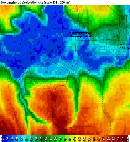
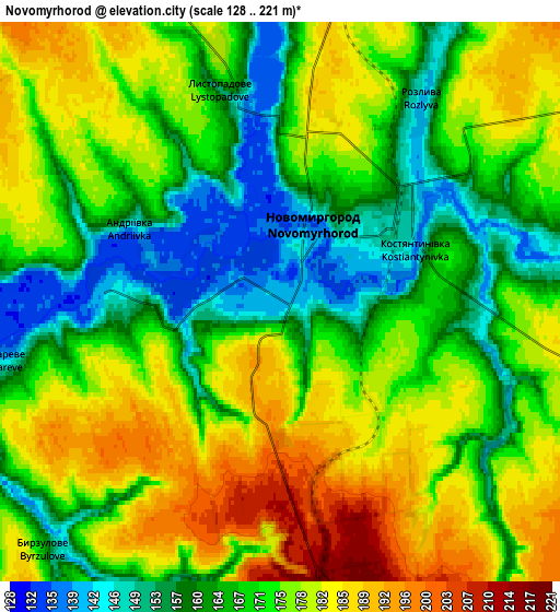
Below is the Elevation map of Novomyrhorod, which displays elevation range with different colors. Scale of the first map is from 131 to 200 m (430 to 656 ft) with average elevation of 159.5 meters (=523 ft) [note 1]
These maps also provides idea of topography and contour of this city, they are displayed at different zoom levels. More info about maps, scale and edge coordinates you can find below images.
| \ | Map #1 | Map #2 | Topo.Map |
| Scale [m] | 131..200 m | 128..221 m | × |
| Scale [ft] | 430..656 ft | 420..725 ft | × |
| Average | 159.5 m = 523 ft | 171.7 m = 563 ft | × |
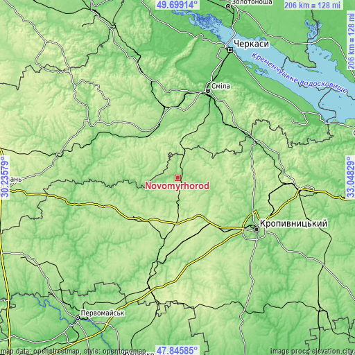
| Width | 6.44 km = 4 mi | 12.88 km = 8 mi | 206.1 km = 128.1 mi |
| Height | 6.44 km = 4 mi | 12.88 km = 8 mi | 206.1 km = 128.1 mi |
| ↑Max Latitude | 48.809999° | 48.838931° | 49.69914° |
| Latitude at center | 48.78105° | 48.78105° | 48.78105° |
| ↓Min Latitude | 48.752084° | 48.723102° | 47.84585° |
| ← Min Longitude | 31.598095° | 31.554149° | 30.23579° |
| Longitude center | 31.64204° | 31.64204° | 31.64204° |
| →Max Longitude | 31.685985° | 31.729931° | 33.04829° |
Nearby cities:
Cities around Novomyrhorod sort by population:
• Smila elevation 101 m
52.2 km,  20°
20°
• Vatutine 141 m
49.7 km,  301°
301°
• Shpola 150 m
30.9 km,  324°
324°
• Novoukrayinka 156 m
51.2 km,  189°
189°
• Kamianka 127 m
43.8 km,  50°
50°
• Mala Vyska 185 m
15.3 km,  181°
181°
• Oleksandrivka 127 m
47.9 km,  64°
64°
• Zlynka 177 m
33.8 km, 192°
• Lebedyn 197 m
21.9 km,  337°
337°
• Kapitanivka 193 m
16.1 km, 19°
• Yurkivka 128 m
47.9 km, 302°
• Tsvitkove 175 m
42 km,  349°
349°
Multilingual:
 En español:
Novomyrhorod elevación 140 m.
 En France:
Novomyrhorod élévation 140 m.
 Auf Deutsch:
Nowomyrhorod höhe über dem Meeresspiegel ist 140 m.

Sources and notes:
- [note 1] Map square and city borders are not equal. Map elevation data is calculated only from area inside that square.
- [src 1] Elevation data from geonames database provided with same terms of usage.
- [src 2] The elevation map of Novomyrhorod is generated using elevation data from NASA's 3 arcsec (90m) resolution SRTM data.
- [src 3] Base (background) map © OpenStreetMap contributors tiles are generated by Geofabrik and OpenTopoMap.
Copyright & License:
This Novomyrhorod Elevation Map is licensed under CC BY-SA. You may reuse any part from this page, if you give a proper credit by linking to this URL:
 More info on terms of use page.