Zlynka elevation
Zlynka (Kirovohrad), Ukraine elevation is 177 meters and Zlynka elevation in feet is 581 ft above sea level [src 1]. Zlynka is a populated place (feature code) with elevation that is 20 meters (66 ft) bigger than average city elevation in Ukraine.
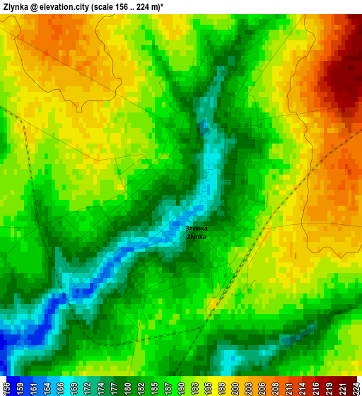
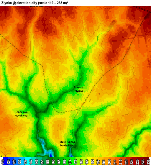
Below is the Elevation map of Zlynka, which displays elevation range with different colors. Scale of the first map is from 156 to 224 m (512 to 735 ft) with average elevation of 189 meters (=620 ft) [note 1]
These maps also provides idea of topography and contour of this city, they are displayed at different zoom levels. More info about maps, scale and edge coordinates you can find below images.
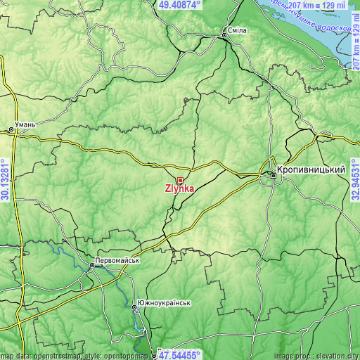
| \ | Map #1 | Map #2 | Topo.Map |
| Scale [m] | 156..224 m | 119..238 m | × |
| Scale [ft] | 512..735 ft | 390..781 ft | × |
| Average | 189 m = 620 ft | 196.3 m = 644 ft | × |
| Width | 6.48 km = 4 mi | 12.95 km = 8 mi | 207.3 km = 128.8 mi |
| Height | 6.48 km = 4 mi | 12.95 km = 8 mi | 207.3 km = 128.8 mi |
| ↑Max Latitude | 48.514329° | 48.543432° | 49.40874° |
| Latitude at center | 48.48521° | 48.48521° | 48.48521° |
| ↓Min Latitude | 48.456074° | 48.426921° | 47.54455° |
| ← Min Longitude | 31.495115° | 31.451169° | 30.13281° |
| Longitude center | 31.53906° | 31.53906° | 31.53906° |
| →Max Longitude | 31.583005° | 31.626951° | 32.94531° |
Nearby cities:
Cities around Zlynka sort by population:
• Kropyvnytskyi elevation 114 m
53.2 km,  86°
86°
• Novoukrayinka 156 m
17.7 km,  182°
182°
• Novomyrhorod 140 m
33.8 km,  12°
12°
• Mala Vyska 185 m
19 km,  22°
22°
• Pomichna 204 m
28.5 km,  198°
198°
• Rivne 151 m
30.9 km,  148°
148°
• Lebedyn 197 m
53.1 km,  359°
359°
• Lysa Hora 104 m
47.2 km,  222°
222°
• Lypnyazhka 131 m
34.4 km,  262°
262°
• Tyshkivka 174 m
44 km,  271°
271°
• Kapitanivka 193 m
49.8 km, 15°
• Dobrovelychkivka 186 m
28.6 km,  247°
247°
Multilingual:
 En español:
Zlynka elevación 177 m.
 En France:
Zlynka élévation 177 m.


Sources and notes:
- [note 1] Map square and city borders are not equal. Map elevation data is calculated only from area inside that square.
- [src 1] Elevation data from geonames database provided with same terms of usage.
- [src 2] The elevation map of Zlynka is generated using elevation data from NASA's 3 arcsec (90m) resolution SRTM data.
- [src 3] Base (background) map © OpenStreetMap contributors tiles are generated by Geofabrik and OpenTopoMap.
Copyright & License:
This Zlynka Elevation Map is licensed under CC BY-SA. You may reuse any part from this page, if you give a proper credit by linking to this URL:
 More info on terms of use page.