Lysa Hora elevation
Lysa Hora (Mykolaiv), Ukraine elevation is 104 meters and Lysa Hora elevation in feet is 341 ft above sea level [src 1]. Lysa Hora is a populated place (feature code) with elevation that is 53 meters (174 ft) smaller than average city elevation in Ukraine.
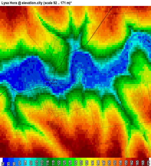
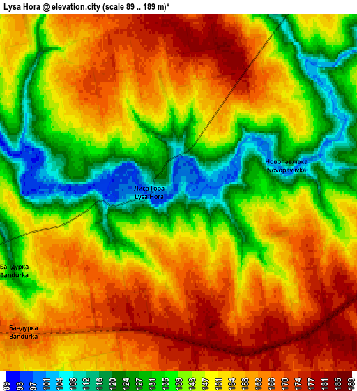
Below is the Elevation map of Lysa Hora, which displays elevation range with different colors. Scale of the first map is from 92 to 171 m (302 to 561 ft) with average elevation of 133.5 meters (=438 ft) [note 1]
These maps also provides idea of topography and contour of this city, they are displayed at different zoom levels. More info about maps, scale and edge coordinates you can find below images.
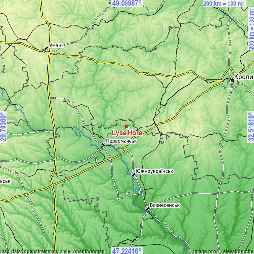
| \ | Map #1 | Map #2 | Topo.Map |
| Scale [m] | 92..171 m | 89..189 m | × |
| Scale [ft] | 302..561 ft | 292..620 ft | × |
| Average | 133.5 m = 438 ft | 148.4 m = 487 ft | × |
| Width | 6.52 km = 4.1 mi | 13.03 km = 8.1 mi | 208.6 km = 129.6 mi |
| Height | 6.52 km = 4.1 mi | 13.03 km = 8.1 mi | 208.5 km = 129.6 mi |
| ↑Max Latitude | 48.199889° | 48.229172° | 49.09987° |
| Latitude at center | 48.17059° | 48.17059° | 48.17059° |
| ↓Min Latitude | 48.141274° | 48.111941° | 47.22416° |
| ← Min Longitude | 31.065995° | 31.022049° | 29.70369° |
| Longitude center | 31.10994° | 31.10994° | 31.10994° |
| →Max Longitude | 31.153885° | 31.197831° | 32.51619° |
Nearby cities:
Cities around Lysa Hora sort by population:
• Pervomays’k elevation 76 m
23.8 km,  233°
233°
• Novoukrayinka 156 m
35.5 km,  60°
60°
• Pomichna 204 m
24 km,  70°
70°
• Arbuzynka 124 m
32.9 km,  151°
151°
• Pobugskoye 121 m
38.4 km,  269°
269°
• Lypnyazhka 131 m
30.8 km,  355°
355°
• Tyshkivka 174 m
38.3 km,  341°
341°
• Kostyantynivka 34 m
38.3 km,  177°
177°
• Pidhorodna 170 m
17.8 km,  246°
246°
• Myhiya 72 m
18.9 km,  218°
218°
• Dobrovelychkivka 186 m
24.7 km,  12°
12°
• Vil’shanka 104 m
18.8 km,  292°
292°
Multilingual:
 En español:
Lysa Hora elevación 104 m.
 En France:
Lysa Hora élévation 104 m.
 Auf Deutsch:
Lysa Hora höhe über dem Meeresspiegel ist 104 m.

Sources and notes:
- [note 1] Map square and city borders are not equal. Map elevation data is calculated only from area inside that square.
- [src 1] Elevation data from geonames database provided with same terms of usage.
- [src 2] The elevation map of Lysa Hora is generated using elevation data from NASA's 3 arcsec (90m) resolution SRTM data.
- [src 3] Base (background) map © OpenStreetMap contributors tiles are generated by Geofabrik and OpenTopoMap.
Copyright & License:
This Lysa Hora Elevation Map is licensed under CC BY-SA. You may reuse any part from this page, if you give a proper credit by linking to this URL:
 More info on terms of use page.