Mirovka elevation
Mirovka (Kyiv), Ukraine elevation is 168 meters and Mirovka elevation in feet is 551 ft above sea level [src 1]. Mirovka is a populated place (feature code) with elevation that is 11 meters (36 ft) bigger than average city elevation in Ukraine.
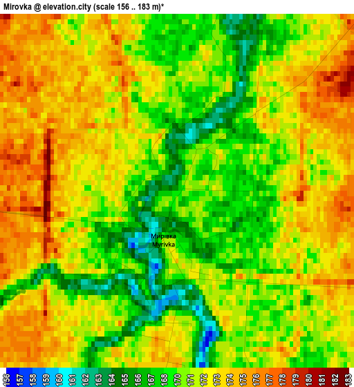
Below is the Elevation map of Mirovka, which displays elevation range with different colors. Scale of the first map is from 156 to 183 m (512 to 600 ft) with average elevation of 171.1 meters (=561 ft) [note 1]
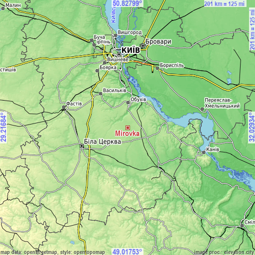
These maps also provides idea of topography and contour of this city, they are displayed at different zoom levels. More info about maps, scale and edge coordinates you can find below images.
| \ | Map #1 | Topo.Map |
| Scale [m] | 156..183 m | × |
| Scale [ft] | 512..600 ft | × |
| Average | 171.1 m = 561 ft | × |
| Width | 6.29 km = 3.9 mi | 201.3 km = 125.1 mi |
| Height | 6.29 km = 3.9 mi | 201.3 km = 125.1 mi |
| ↑Max Latitude | 49.95954° | 50.82799° |
| Latitude at center | 49.93126° | 49.93126° |
| ↓Min Latitude | 49.902964° | 49.01753° |
| ← Min Longitude | 30.579145° | 29.21684° |
| Longitude center | 30.62309° | 30.62309° |
| →Max Longitude | 30.667035° | 32.02934° |
Nearby cities:
Cities around Mirovka sort by population:
• Bila Tserkva elevation 178 m
39 km,  249°
249°
• Vasylkiv 164 m
36 km,  322°
322°
• Obukhiv 136 m
19.5 km,  359°
359°
• Ukrainka 98 m
25.1 km,  20°
20°
• Kaharlyk 159 m
16.6 km,  117°
117°
• Uzyn 179 m
18.9 km,  231°
231°
• Rzhyshchiv 90 m
30.6 km,  82°
82°
• Voronkov 99 m
37.9 km,  31°
31°
• Trypillia 132 m
23.6 km, 28°
• Karapyshi 146 m
34.3 km,  159°
159°
• Stayki 184 m
25.9 km,  50°
50°
• Rokytne 155 m
29.2 km,  201°
201°
Multilingual:
 En español:
Mirovka elevación 168 m.
 En France:
Mirovka élévation 168 m.


Sources and notes:
- [note 1] Map square and city borders are not equal. Map elevation data is calculated only from area inside that square.
- [src 1] Elevation data from geonames database provided with same terms of usage.
- [src 2] The elevation map of Mirovka is generated using elevation data from NASA's 3 arcsec (90m) resolution SRTM data.
- [src 3] Base (background) map © OpenStreetMap contributors tiles are generated by Geofabrik and OpenTopoMap.
Copyright & License:
This Mirovka Elevation Map is licensed under CC BY-SA. You may reuse any part from this page, if you give a proper credit by linking to this URL:
 More info on terms of use page.