Voronkov elevation
Voronkov (Kyiv), Ukraine elevation is 99 meters and Voronkov elevation in feet is 325 ft above sea level [src 1]. Voronkov is a populated place (feature code) with elevation that is 58 meters (190 ft) smaller than average city elevation in Ukraine.
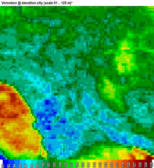
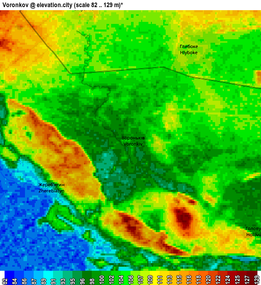
Below is the Elevation map of Voronkov, which displays elevation range with different colors. Scale of the first map is from 91 to 125 m (299 to 410 ft) with average elevation of 102.5 meters (=336 ft) [note 1]
These maps also provides idea of topography and contour of this city, they are displayed at different zoom levels. More info about maps, scale and edge coordinates you can find below images.
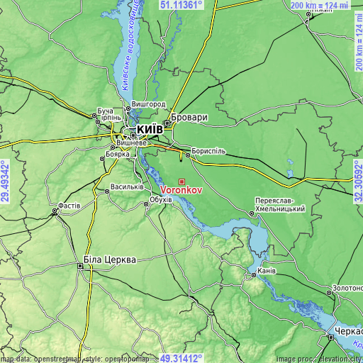
| \ | Map #1 | Map #2 | Topo.Map |
| Scale [m] | 91..125 m | 82..129 m | × |
| Scale [ft] | 299..410 ft | 269..423 ft | × |
| Average | 102.5 m = 336 ft | 103.3 m = 339 ft | × |
| Width | 6.25 km = 3.9 mi | 12.51 km = 7.8 mi | 200.1 km = 124.3 mi |
| Height | 6.25 km = 3.9 mi | 12.51 km = 7.8 mi | 200.1 km = 124.3 mi |
| ↑Max Latitude | 50.250458° | 50.27855° | 51.11361° |
| Latitude at center | 50.22235° | 50.22235° | 50.22235° |
| ↓Min Latitude | 50.194225° | 50.166084° | 49.31412° |
| ← Min Longitude | 30.855725° | 30.811779° | 29.49342° |
| Longitude center | 30.89967° | 30.89967° | 30.89967° |
| →Max Longitude | 30.943615° | 30.987561° | 32.30592° |
Nearby cities:
Cities around Voronkov sort by population:
• Boryspil’ elevation 113 m
15 km,  15°
15°
• Obukhiv 136 m
23.8 km,  237°
237°
• Ukrainka 98 m
14 km,  231°
231°
• Rzhyshchiv 90 m
30.1 km,  159°
159°
• Trebukhiv 114 m
29.1 km,  0°
0°
• Hnidyn 93 m
17.9 km,  311°
311°
• Knyazhichi 111 m
28 km,  342°
342°
• Khotiv 128 m
32.9 km,  291°
291°
• Trypillia 132 m
14.3 km,  215°
215°
• Stayki 184 m
16 km,  178°
178°
• Prolisky 129 m
20.6 km, 335°
• Kirove 103 m
22.6 km,  43°
43°
Multilingual:
 En español:
Voronkov elevación 99 m.
 En France:
Voronkov élévation 99 m.


Sources and notes:
- [note 1] Map square and city borders are not equal. Map elevation data is calculated only from area inside that square.
- [src 1] Elevation data from geonames database provided with same terms of usage.
- [src 2] The elevation map of Voronkov is generated using elevation data from NASA's 3 arcsec (90m) resolution SRTM data.
- [src 3] Base (background) map © OpenStreetMap contributors tiles are generated by Geofabrik and OpenTopoMap.
Copyright & License:
This Voronkov Elevation Map is licensed under CC BY-SA. You may reuse any part from this page, if you give a proper credit by linking to this URL:
 More info on terms of use page.