Obukhiv elevation
Obukhiv (Kyiv, Obukhiv Raion), Ukraine elevation is 136 meters and Obukhiv elevation in feet is 446 ft above sea level [src 1]. Obukhiv is a seat of a second-order administrative division (feature code) with elevation that is 21 meters (69 ft) smaller than average city elevation in Ukraine.
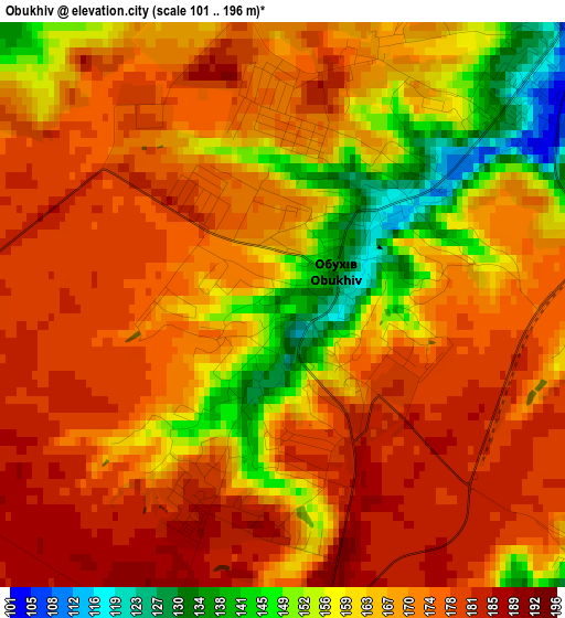
Below is the Elevation map of Obukhiv, which displays elevation range with different colors. Scale of the first map is from 101 to 196 m (331 to 643 ft) with average elevation of 168.4 meters (=552 ft) [note 1]
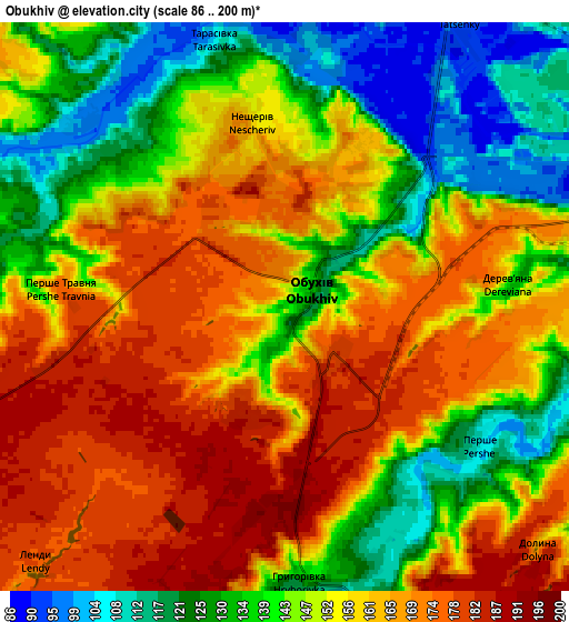
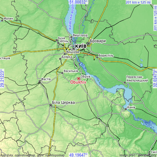
These maps also provides idea of topography and contour of this city, they are displayed at different zoom levels. More info about maps, scale and edge coordinates you can find below images.
| \ | Map #1 | Map #2 | Topo.Map |
| Scale [m] | 101..196 m | 86..200 m | × |
| Scale [ft] | 331..643 ft | 282..656 ft | × |
| Average | 168.4 m = 552 ft | 152 m = 499 ft | × |
| Width | 6.27 km = 3.9 mi | 12.54 km = 7.8 mi | 200.6 km = 124.6 mi |
| Height | 6.27 km = 3.9 mi | 12.54 km = 7.8 mi | 200.6 km = 124.6 mi |
| ↑Max Latitude | 50.135066° | 50.163226° | 51.00032° |
| Latitude at center | 50.10689° | 50.10689° | 50.10689° |
| ↓Min Latitude | 50.078697° | 50.050488° | 49.19647° |
| ← Min Longitude | 30.574535° | 30.530589° | 29.21223° |
| Longitude center | 30.61848° | 30.61848° | 30.61848° |
| →Max Longitude | 30.662425° | 30.706371° | 32.02473° |
Nearby cities:
Cities around Obukhiv sort by population:
• Vasylkiv elevation 164 m
23.5 km,  292°
292°
• Boyarka 181 m
32.9 km,  315°
315°
• Ukrainka 98 m
10 km,  66°
66°
• Kaharlyk 159 m
31.1 km,  151°
151°
• Hlevakha 188 m
27.9 km,  311°
311°
• Chabany 188 m
29.5 km,  331°
331°
• Hnidyn 93 m
25.5 km,  14°
14°
• Khotiv 128 m
27.1 km,  336°
336°
• Voronkov 99 m
23.8 km,  57°
57°
• Trypillia 132 m
11.7 km,  83°
83°
• Stayki 184 m
20.6 km,  98°
98°
• Mirovka 168 m
19.5 km,  179°
179°
Multilingual:
 En español:
Obukhiv elevación 136 m.
 En France:
Oboukhiv élévation 136 m.


Sources and notes:
- [note 1] Map square and city borders are not equal. Map elevation data is calculated only from area inside that square.
- [src 1] Elevation data from geonames database provided with same terms of usage.
- [src 2] The elevation map of Obukhiv is generated using elevation data from NASA's 3 arcsec (90m) resolution SRTM data.
- [src 3] Base (background) map © OpenStreetMap contributors tiles are generated by Geofabrik and OpenTopoMap.
Copyright & License:
This Obukhiv Elevation Map is licensed under CC BY-SA. You may reuse any part from this page, if you give a proper credit by linking to this URL:
 More info on terms of use page.