Murafa elevation
Murafa (Vinnyts'ka), Ukraine elevation is 233 meters and Murafa elevation in feet is 764 ft above sea level [src 1]. Murafa is a populated place (feature code) with elevation that is 76 meters (249 ft) bigger than average city elevation in Ukraine.
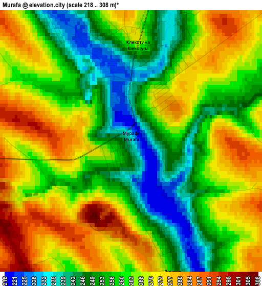
Below is the Elevation map of Murafa, which displays elevation range with different colors. Scale of the first map is from 218 to 308 m (715 to 1010 ft) with average elevation of 262.6 meters (=862 ft) [note 1]
These maps also provides idea of topography and contour of this city, they are displayed at different zoom levels. More info about maps, scale and edge coordinates you can find below images.
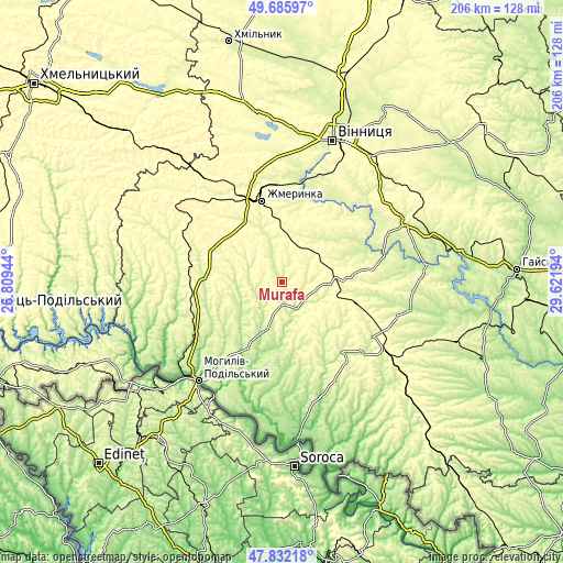
| \ | Map #1 | Topo.Map |
| Scale [m] | 218..308 m | × |
| Scale [ft] | 715..1010 ft | × |
| Average | 262.6 m = 862 ft | × |
| Width | 6.44 km = 4 mi | 206.1 km = 128.1 mi |
| Height | 6.44 km = 4 mi | 206.1 km = 128.1 mi |
| ↑Max Latitude | 48.796587° | 49.68597° |
| Latitude at center | 48.76763° | 48.76763° |
| ↓Min Latitude | 48.738657° | 47.83218° |
| ← Min Longitude | 28.171745° | 26.80944° |
| Longitude center | 28.21569° | 28.21569° |
| →Max Longitude | 28.259635° | 29.62194° |
Nearby cities:
Cities around Murafa sort by population:
• Zhmerynka elevation 318 m
30.9 km,  345°
345°
• Mohyliv-Podilskyi 68 m
47.1 km,  220°
220°
• Vapnyarka 313 m
46.6 km,  123°
123°
• Sharhorod 271 m
10.4 km,  262°
262°
• Sutysky 250 m
33.9 km,  25°
25°
• Brailiv 260 m
38.2 km,  355°
355°
• Vendychany 234 m
35.5 km,  240°
240°
• Klembivka 151 m
44.3 km,  161°
161°
• Chernivtsi 196 m
26.1 km,  196°
196°
• Kopayhorod 267 m
32.3 km,  288°
288°
• Tyvriv 279 m
34.8 km,  37°
37°
• Tomashpil’ 240 m
33.4 km,  138°
138°
Multilingual:
 En español:
Murafa elevación 233 m.
 En France:
Murafa élévation 233 m.


Sources and notes:
- [note 1] Map square and city borders are not equal. Map elevation data is calculated only from area inside that square.
- [src 1] Elevation data from geonames database provided with same terms of usage.
- [src 2] The elevation map of Murafa is generated using elevation data from NASA's 3 arcsec (90m) resolution SRTM data.
- [src 3] Base (background) map © OpenStreetMap contributors tiles are generated by Geofabrik and OpenTopoMap.
Copyright & License:
This Murafa Elevation Map is licensed under CC BY-SA. You may reuse any part from this page, if you give a proper credit by linking to this URL:
 More info on terms of use page.