Brailiv elevation
Brailiv (Vinnyts'ka), Ukraine elevation is 260 meters and Brailiv elevation in feet is 853 ft above sea level [src 1]. Brailiv is a populated place (feature code) with elevation that is 103 meters (338 ft) bigger than average city elevation in Ukraine.
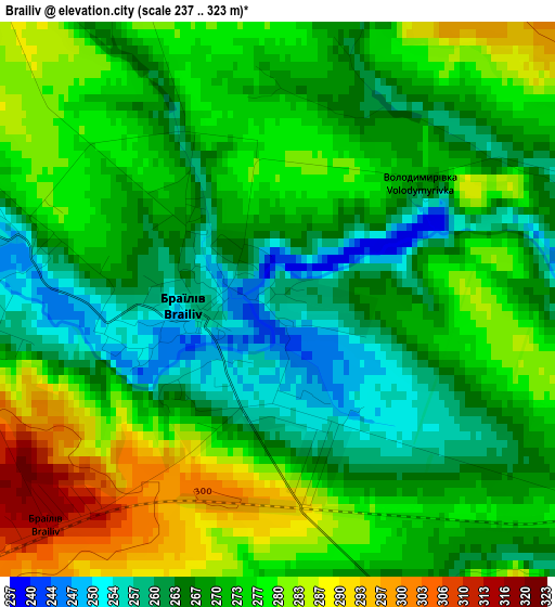
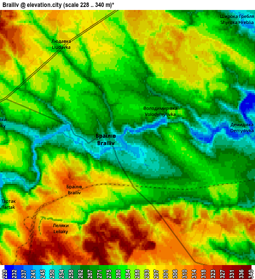
Below is the Elevation map of Brailiv, which displays elevation range with different colors. Scale of the first map is from 237 to 323 m (778 to 1060 ft) with average elevation of 272.1 meters (=893 ft) [note 1]
These maps also provides idea of topography and contour of this city, they are displayed at different zoom levels. More info about maps, scale and edge coordinates you can find below images.
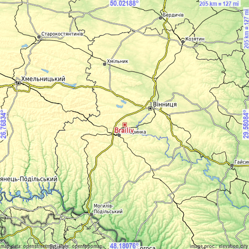
| \ | Map #1 | Map #2 | Topo.Map |
| Scale [m] | 237..323 m | 228..340 m | × |
| Scale [ft] | 778..1060 ft | 748..1115 ft | × |
| Average | 272.1 m = 893 ft | 284.5 m = 933 ft | × |
| Width | 6.4 km = 4 mi | 12.79 km = 7.9 mi | 204.7 km = 127.2 mi |
| Height | 6.4 km = 4 mi | 12.79 km = 7.9 mi | 204.7 km = 127.2 mi |
| ↑Max Latitude | 49.138619° | 49.167361° | 50.02188° |
| Latitude at center | 49.10986° | 49.10986° | 49.10986° |
| ↓Min Latitude | 49.081085° | 49.052292° | 48.18076° |
| ← Min Longitude | 28.130645° | 28.086699° | 26.76834° |
| Longitude center | 28.17459° | 28.17459° | 28.17459° |
| →Max Longitude | 28.218535° | 28.262481° | 29.58084° |
Nearby cities:
Cities around Brailiv sort by population:
• Vinnytsia elevation 235 m
26.1 km,  58°
58°
• Zhmerynka 318 m
9.3 km,  209°
209°
• Bar 282 m
36 km,  264°
264°
• Sharhorod 271 m
40 km,  190°
190°
• Lityn 268 m
24.9 km,  344°
344°
• Voronovytsya 287 m
36.8 km,  90°
90°
• Sutysky 250 m
19.2 km,  112°
112°
• Pavlivka 261 m
42.3 km,  29°
29°
• Sobolivka 246 m
42.8 km,  53°
53°
• Murafa 233 m
38.2 km,  175°
175°
• Kopayhorod 267 m
39.2 km,  224°
224°
• Tyvriv 279 m
26.6 km, 113°
Multilingual:
 En español:
Brailiv elevación 260 m.
 En France:
Brailiv élévation 260 m.


Sources and notes:
- [note 1] Map square and city borders are not equal. Map elevation data is calculated only from area inside that square.
- [src 1] Elevation data from geonames database provided with same terms of usage.
- [src 2] The elevation map of Brailiv is generated using elevation data from NASA's 3 arcsec (90m) resolution SRTM data.
- [src 3] Base (background) map © OpenStreetMap contributors tiles are generated by Geofabrik and OpenTopoMap.
Copyright & License:
This Brailiv Elevation Map is licensed under CC BY-SA. You may reuse any part from this page, if you give a proper credit by linking to this URL:
 More info on terms of use page.