Sutysky elevation
Sutysky (Vinnyts'ka), Ukraine elevation is 250 meters and Sutysky elevation in feet is 820 ft above sea level [src 1]. Sutysky is a populated place (feature code) with elevation that is 93 meters (305 ft) bigger than average city elevation in Ukraine.
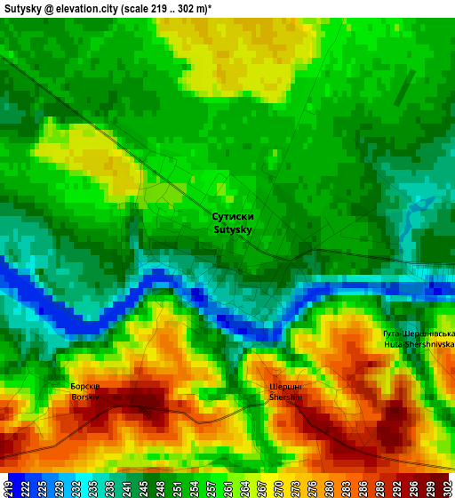
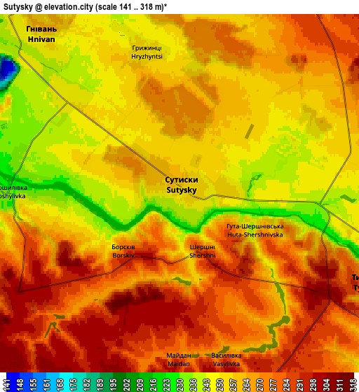
Below is the Elevation map of Sutysky, which displays elevation range with different colors. Scale of the first map is from 219 to 302 m (719 to 991 ft) with average elevation of 257.6 meters (=845 ft) [note 1]
These maps also provides idea of topography and contour of this city, they are displayed at different zoom levels. More info about maps, scale and edge coordinates you can find below images.
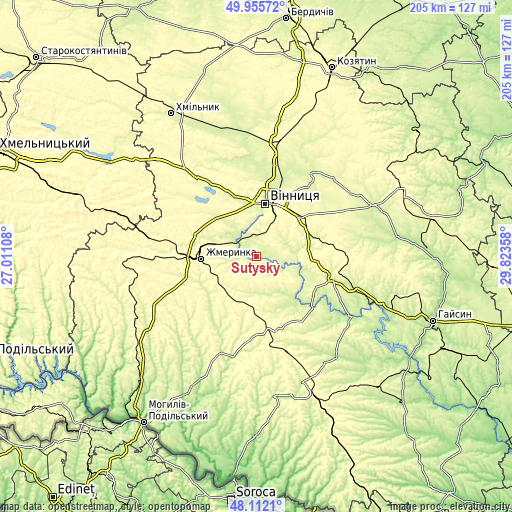
| \ | Map #1 | Map #2 | Topo.Map |
| Scale [m] | 219..302 m | 141..318 m | × |
| Scale [ft] | 719..991 ft | 463..1043 ft | × |
| Average | 257.6 m = 845 ft | 264 m = 866 ft | × |
| Width | 6.41 km = 4 mi | 12.81 km = 8 mi | 205 km = 127.4 mi |
| Height | 6.41 km = 4 mi | 12.81 km = 8 mi | 205 km = 127.4 mi |
| ↑Max Latitude | 49.071248° | 49.100029° | 49.95572° |
| Latitude at center | 49.04245° | 49.04245° | 49.04245° |
| ↓Min Latitude | 49.013636° | 48.984804° | 48.1121° |
| ← Min Longitude | 28.373385° | 28.329439° | 27.01108° |
| Longitude center | 28.41733° | 28.41733° | 28.41733° |
| →Max Longitude | 28.461275° | 28.505221° | 29.82358° |
Nearby cities:
Cities around Sutysky sort by population:
• Vinnytsia elevation 235 m
21.7 km,  12°
12°
• Zhmerynka 318 m
22.3 km,  268°
268°
• Nemyriv 272 m
31.7 km,  104°
104°
• Sharhorod 271 m
40.5 km,  218°
218°
• Lityn 268 m
39.8 km,  322°
322°
• Turbiv 252 m
40.5 km,  33°
33°
• Voronovytsya 287 m
20.6 km,  68°
68°
• Brailiv 260 m
19.2 km,  292°
292°
• Sobolivka 246 m
36.8 km, 27°
• Murafa 233 m
33.9 km,  205°
205°
• Nova Pryluka 264 m
42.3 km, 29°
• Tyvriv 279 m
7.4 km,  115°
115°
Multilingual:
 En español:
Sutysky elevación 250 m.
 En France:
Sutysky élévation 250 m.


Sources and notes:
- [note 1] Map square and city borders are not equal. Map elevation data is calculated only from area inside that square.
- [src 1] Elevation data from geonames database provided with same terms of usage.
- [src 2] The elevation map of Sutysky is generated using elevation data from NASA's 3 arcsec (90m) resolution SRTM data.
- [src 3] Base (background) map © OpenStreetMap contributors tiles are generated by Geofabrik and OpenTopoMap.
Copyright & License:
This Sutysky Elevation Map is licensed under CC BY-SA. You may reuse any part from this page, if you give a proper credit by linking to this URL:
 More info on terms of use page.