Sharhorod elevation
Sharhorod (Vinnyts'ka), Ukraine elevation is 271 meters and Sharhorod elevation in feet is 889 ft above sea level [src 1]. Sharhorod is a seat of a second-order administrative division (feature code) with elevation that is 114 meters (374 ft) bigger than average city elevation in Ukraine.
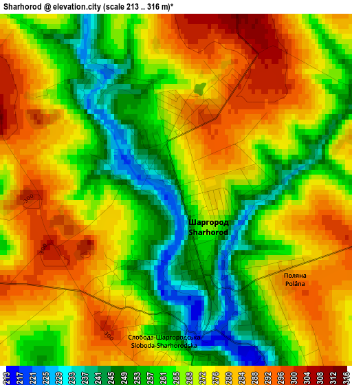
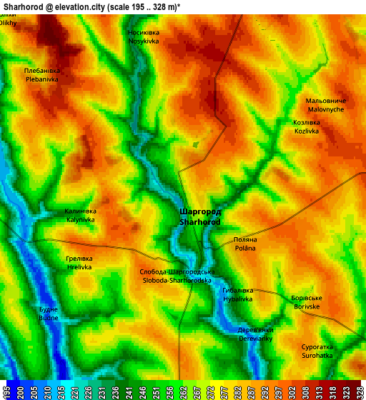
Below is the Elevation map of Sharhorod, which displays elevation range with different colors. Scale of the first map is from 213 to 316 m (699 to 1037 ft) with average elevation of 270.1 meters (=886 ft) [note 1]
These maps also provides idea of topography and contour of this city, they are displayed at different zoom levels. More info about maps, scale and edge coordinates you can find below images.
| \ | Map #1 | Map #2 | Topo.Map |
| Scale [m] | 213..316 m | 195..328 m | × |
| Scale [ft] | 699..1037 ft | 640..1076 ft | × |
| Average | 270.1 m = 886 ft | 271.6 m = 891 ft | × |
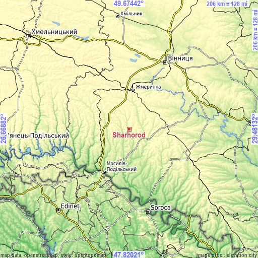
| Width | 6.44 km = 4 mi | 12.89 km = 8 mi | 206.2 km = 128.1 mi |
| Height | 6.44 km = 4 mi | 12.89 km = 8 mi | 206.2 km = 128.1 mi |
| ↑Max Latitude | 48.784833° | 48.81378° | 49.67442° |
| Latitude at center | 48.75587° | 48.75587° | 48.75587° |
| ↓Min Latitude | 48.72689° | 48.697893° | 47.82021° |
| ← Min Longitude | 28.031125° | 27.987179° | 26.66882° |
| Longitude center | 28.07507° | 28.07507° | 28.07507° |
| →Max Longitude | 28.119015° | 28.162961° | 29.48132° |
Nearby cities:
Cities around Sharhorod sort by population:
• Zhmerynka elevation 318 m
31.4 km,  4°
4°
• Mohyliv-Podilskyi 68 m
40 km,  210°
210°
• Sutysky 250 m
40.5 km,  38°
38°
• Murovani Kurylivtsi 172 m
40.9 km,  264°
264°
• Brailiv 260 m
40 km,  10°
10°
• Vendychany 234 m
26.2 km,  232°
232°
• Chernivtsi 196 m
23.9 km,  173°
173°
• Serebriya 77 m
42.4 km,  218°
218°
• Murafa 233 m
10.4 km,  82°
82°
• Kopayhorod 267 m
23.4 km,  299°
299°
• Tyvriv 279 m
42.8 km,  47°
47°
• Tomashpil’ 240 m
40.2 km,  126°
126°
Multilingual:
 En español:
Sharhorod elevación 271 m.
 En France:
Sharhorod élévation 271 m.
 Auf Deutsch:
Sharhorod höhe über dem Meeresspiegel ist 271 m.

Sources and notes:
- [note 1] Map square and city borders are not equal. Map elevation data is calculated only from area inside that square.
- [src 1] Elevation data from geonames database provided with same terms of usage.
- [src 2] The elevation map of Sharhorod is generated using elevation data from NASA's 3 arcsec (90m) resolution SRTM data.
- [src 3] Base (background) map © OpenStreetMap contributors tiles are generated by Geofabrik and OpenTopoMap.
Copyright & License:
This Sharhorod Elevation Map is licensed under CC BY-SA. You may reuse any part from this page, if you give a proper credit by linking to this URL:
 More info on terms of use page.