Vapnyarka elevation
Vapnyarka (Vinnyts'ka), Ukraine elevation is 313 meters and Vapnyarka elevation in feet is 1027 ft above sea level [src 1]. Vapnyarka is a populated place (feature code) with elevation that is 156 meters (512 ft) bigger than average city elevation in Ukraine.
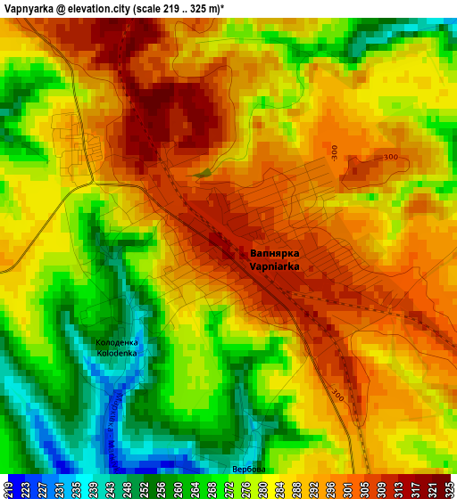
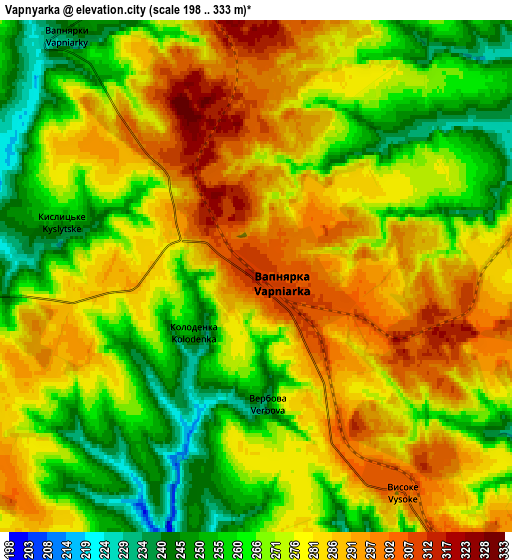
Below is the Elevation map of Vapnyarka, which displays elevation range with different colors. Scale of the first map is from 219 to 325 m (719 to 1066 ft) with average elevation of 283.1 meters (=929 ft) [note 1]
These maps also provides idea of topography and contour of this city, they are displayed at different zoom levels. More info about maps, scale and edge coordinates you can find below images.
| \ | Map #1 | Map #2 | Topo.Map |
| Scale [m] | 219..325 m | 198..333 m | × |
| Scale [ft] | 719..1066 ft | 650..1093 ft | × |
| Average | 283.1 m = 929 ft | 274.7 m = 901 ft | × |
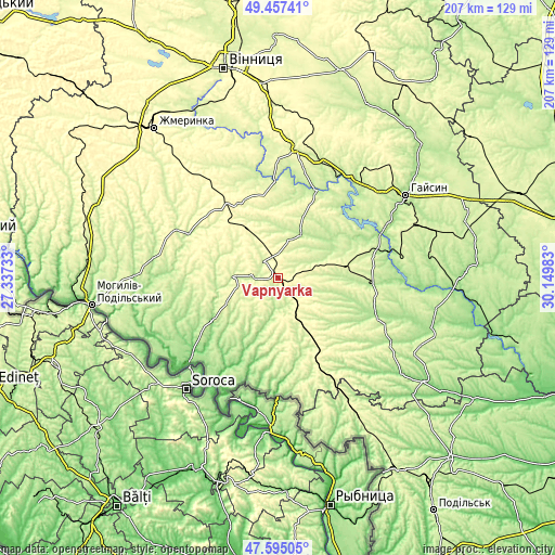
| Width | 6.47 km = 4 mi | 12.94 km = 8 mi | 207.1 km = 128.7 mi |
| Height | 6.47 km = 4 mi | 12.94 km = 8 mi | 207.1 km = 128.7 mi |
| ↑Max Latitude | 48.563881° | 48.592955° | 49.45741° |
| Latitude at center | 48.53479° | 48.53479° | 48.53479° |
| ↓Min Latitude | 48.505683° | 48.476558° | 47.59505° |
| ← Min Longitude | 28.699635° | 28.655689° | 27.33733° |
| Longitude center | 28.74358° | 28.74358° | 28.74358° |
| →Max Longitude | 28.787525° | 28.831471° | 30.14983° |
Nearby cities:
Cities around Vapnyarka sort by population:
• Ladyzhyn elevation 205 m
39.9 km,  65°
65°
• Tulchyn 231 m
17.3 km,  25°
25°
• Kryzhopil’ 299 m
19.2 km,  151°
151°
• Bratslav 215 m
35.1 km,  24°
24°
• Klembivka 151 m
29.3 km,  236°
236°
• Obodivka 185 m
39.9 km,  111°
111°
• Chernivtsi 196 m
46.3 km,  271°
271°
• Tsybulevka 199 m
31.2 km,  121°
121°
• Torkanivka 207 m
37.9 km,  128°
128°
• Pishchanka 228 m
37.9 km,  163°
163°
• Trostyanets’ 196 m
36.3 km,  94°
94°
• Tomashpil’ 240 m
16.7 km, 272°
Multilingual:
 En español:
Vapnyarka elevación 313 m.
 En France:
Vapnyarka élévation 313 m.
 Auf Deutsch:
Vapnyarka höhe über dem Meeresspiegel ist 313 m.

Sources and notes:
- [note 1] Map square and city borders are not equal. Map elevation data is calculated only from area inside that square.
- [src 1] Elevation data from geonames database provided with same terms of usage.
- [src 2] The elevation map of Vapnyarka is generated using elevation data from NASA's 3 arcsec (90m) resolution SRTM data.
- [src 3] Base (background) map © OpenStreetMap contributors tiles are generated by Geofabrik and OpenTopoMap.
Copyright & License:
This Vapnyarka Elevation Map is licensed under CC BY-SA. You may reuse any part from this page, if you give a proper credit by linking to this URL:
 More info on terms of use page.