Kryzhopil’ elevation
Kryzhopil’ (Vinnyts'ka), Ukraine elevation is 299 meters and Kryzhopil’ elevation in feet is 981 ft above sea level [src 1]. Kryzhopil’ is a seat of a second-order administrative division (feature code) with elevation that is 142 meters (466 ft) bigger than average city elevation in Ukraine.
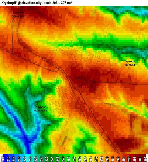
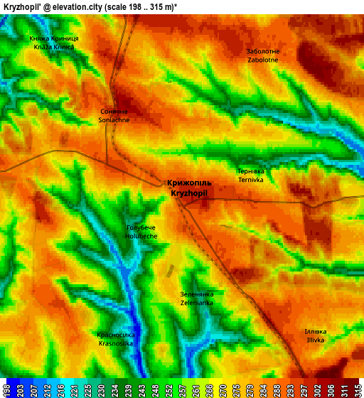
Below is the Elevation map of Kryzhopil’, which displays elevation range with different colors. Scale of the first map is from 206 to 307 m (676 to 1007 ft) with average elevation of 270.2 meters (=886 ft) [note 1]
These maps also provides idea of topography and contour of this city, they are displayed at different zoom levels. More info about maps, scale and edge coordinates you can find below images.
| \ | Map #1 | Map #2 | Topo.Map |
| Scale [m] | 206..307 m | 198..315 m | × |
| Scale [ft] | 676..1007 ft | 650..1033 ft | × |
| Average | 270.2 m = 886 ft | 268.8 m = 882 ft | × |
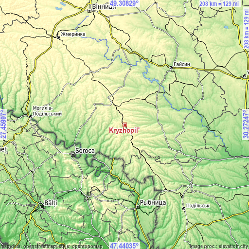
| Width | 6.49 km = 4 mi | 12.98 km = 8.1 mi | 207.7 km = 129.1 mi |
| Height | 6.49 km = 4 mi | 12.98 km = 8.1 mi | 207.7 km = 129.1 mi |
| ↑Max Latitude | 48.412068° | 48.441229° | 49.30829° |
| Latitude at center | 48.38289° | 48.38289° | 48.38289° |
| ↓Min Latitude | 48.353695° | 48.324484° | 47.44035° |
| ← Min Longitude | 28.822275° | 28.778329° | 27.45997° |
| Longitude center | 28.86622° | 28.86622° | 28.86622° |
| →Max Longitude | 28.910165° | 28.954111° | 30.27247° |
Nearby cities:
Cities around Kryzhopil’ sort by population:
• Tulchyn elevation 231 m
32.5 km,  357°
357°
• Kodyma 289 m
36.9 km,  148°
148°
• Vapnyarka 313 m
19.2 km,  331°
331°
• Chechelnyk 168 m
41.5 km,  116°
116°
• Zagnitkiv 222 m
37.2 km,  177°
177°
• Klembivka 151 m
33.6 km,  271°
271°
• Obodivka 185 m
28.3 km,  84°
84°
• Tsybulevka 199 m
17.5 km,  88°
88°
• Torkanivka 207 m
21.8 km,  107°
107°
• Tomashpil’ 240 m
31.3 km,  304°
304°
• Trostyanets’ 196 m
30.6 km,  62°
62°
• Pishchanka 228 m
19.6 km, 175°
Multilingual:
 En español:
Kryzhopil’ elevación 299 m.
 En France:
Kryzhopil’ élévation 299 m.
 Auf Deutsch:
Kryzhopil’ höhe über dem Meeresspiegel ist 299 m.

Sources and notes:
- [note 1] Map square and city borders are not equal. Map elevation data is calculated only from area inside that square.
- [src 1] Elevation data from geonames database provided with same terms of usage.
- [src 2] The elevation map of Kryzhopil’ is generated using elevation data from NASA's 3 arcsec (90m) resolution SRTM data.
- [src 3] Base (background) map © OpenStreetMap contributors tiles are generated by Geofabrik and OpenTopoMap.
Copyright & License:
This Kryzhopil’ Elevation Map is licensed under CC BY-SA. You may reuse any part from this page, if you give a proper credit by linking to this URL:
 More info on terms of use page.