Yampil’ elevation
Yampil’ (Vinnyts'ka), Ukraine elevation is 58 meters and Yampil’ elevation in feet is 190 ft above sea level [src 1]. Yampil’ is a seat of a second-order administrative division (feature code) with elevation that is 99 meters (325 ft) smaller than average city elevation in Ukraine.
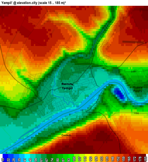
Below is the Elevation map of Yampil’, which displays elevation range with different colors. Scale of the first map is from 15 to 185 m (49 to 607 ft) with average elevation of 112.8 meters (=370 ft) [note 1]
These maps also provides idea of topography and contour of this city, they are displayed at different zoom levels. More info about maps, scale and edge coordinates you can find below images.
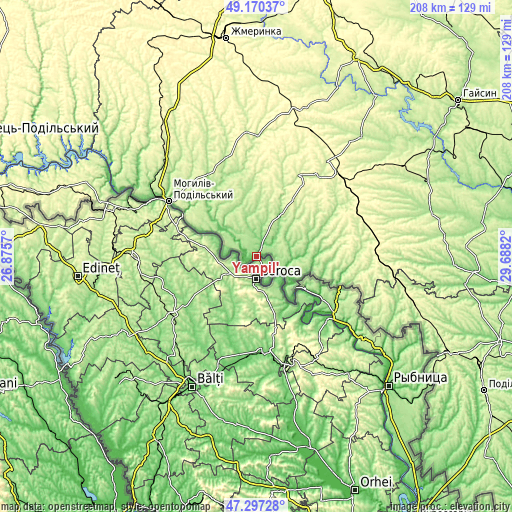
| \ | Map #1 | Topo.Map |
| Scale [m] | 15..185 m | × |
| Scale [ft] | 49..607 ft | × |
| Average | 112.8 m = 370 ft | × |
| Width | 6.51 km = 4 mi | 208.3 km = 129.4 mi |
| Height | 6.51 km = 4 mi | 208.3 km = 129.4 mi |
| ↑Max Latitude | 48.271658° | 49.17037° |
| Latitude at center | 48.2424° | 48.2424° |
| ↓Min Latitude | 48.213125° | 47.29728° |
| ← Min Longitude | 28.238005° | 26.8757° |
| Longitude center | 28.28195° | 28.28195° |
| →Max Longitude | 28.325895° | 29.6882° |
Nearby cities:
Cities around Yampil’ sort by population:
• Mohyliv-Podilskyi elevation 68 m
42.3 km,  302°
302°
• Kryzhopil’ 299 m
45.9 km,  70°
70°
• Vapnyarka 313 m
47.1 km,  46°
46°
• Sharhorod 271 m
59.1 km,  345°
345°
• Vendychany 234 m
54.7 km,  318°
318°
• Zagnitkiv 222 m
50.1 km,  115°
115°
• Klembivka 151 m
19 km,  30°
30°
• Chernivtsi 196 m
35.6 km,  339°
339°
• Serebriya 77 m
47.9 km, 299°
• Murafa 233 m
58.6 km,  355°
355°
• Pishchanka 228 m
44.9 km,  94°
94°
• Tomashpil’ 240 m
37.6 km, 27°
Multilingual:
 En español:
Yampil’ elevación 58 m.
 En France:
Yampil’ élévation 58 m.


Sources and notes:
- [note 1] Map square and city borders are not equal. Map elevation data is calculated only from area inside that square.
- [src 1] Elevation data from geonames database provided with same terms of usage.
- [src 2] The elevation map of Yampil’ is generated using elevation data from NASA's 3 arcsec (90m) resolution SRTM data.
- [src 3] Base (background) map © OpenStreetMap contributors tiles are generated by Geofabrik and OpenTopoMap.
Copyright & License:
This Yampil’ Elevation Map is licensed under CC BY-SA. You may reuse any part from this page, if you give a proper credit by linking to this URL:
 More info on terms of use page.