Boztepe elevation
Boztepe (Kırşehir), Turkey elevation is 1181 meters and Boztepe elevation in feet is 3875 ft above sea level [src 1]. Boztepe is a seat of a second-order administrative division (feature code) with elevation that is 458 meters (1503 ft) bigger than average city elevation in Turkey.
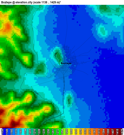
Below is the Elevation map of Boztepe, which displays elevation range with different colors. Scale of the first map is from 1138 to 1429 m (3734 to 4688 ft) with average elevation of 1195.6 meters (=3923 ft) [note 1]
These maps also provides idea of topography and contour of this city, they are displayed at different zoom levels. More info about maps, scale and edge coordinates you can find below images.
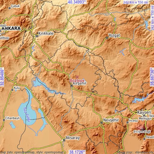
| \ | Map #1 | Topo.Map |
| Scale [m] | 1138..1429 m | × |
| Scale [ft] | 3734..4688 ft | × |
| Average | 1195.6 m = 3923 ft | × |
| Width | 7.57 km = 4.7 mi | 242.1 km = 150.4 mi |
| Height | 7.57 km = 4.7 mi | 242.1 km = 150.4 mi |
| ↑Max Latitude | 39.303733° | 40.34993° |
| Latitude at center | 39.26972° | 39.26972° |
| ↓Min Latitude | 39.23569° | 38.1726° |
| ← Min Longitude | 34.217165° | 32.85486° |
| Longitude center | 34.26111° | 34.26111° |
| →Max Longitude | 34.305055° | 35.66736° |
Nearby cities:
Cities around Boztepe sort by population:
• Kırşehir elevation 997 m
16.1 km,  211°
211°
• Yerköy 770 m
44.6 km,  23°
23°
• Kaman 1126 m
47.2 km,  281°
281°
• Mucur 1084 m
25.4 km,  155°
155°
• Hacıbektaş 1284 m
44.6 km,  145°
145°
• Evren 895 m
47.8 km,  235°
235°
• Akçakent 1395 m
41.7 km,  340°
340°
• Karahasanlı 1019 m
39.7 km,  85°
85°
• Çiçekdağı 957 m
39.6 km, 18°
• Kösefakılı 1355 m
37.6 km, 343°
• Akpınar 1148 m
32.4 km,  308°
308°
• Göllü 1282 m
20.3 km,  9°
9°
Multilingual:
 En español:
Boztepe elevación 1181 m.
 En France:
Boztepe élévation 1181 m.
 Auf Deutsch:
Boztepe höhe über dem Meeresspiegel ist 1181 m.

Sources and notes:
- [note 1] Map square and city borders are not equal. Map elevation data is calculated only from area inside that square.
- [src 1] Elevation data from geonames database provided with same terms of usage.
- [src 2] The elevation map of Boztepe is generated using elevation data from NASA's 3 arcsec (90m) resolution SRTM data.
- [src 3] Base (background) map © OpenStreetMap contributors tiles are generated by Geofabrik and OpenTopoMap.
Copyright & License:
This Boztepe Elevation Map is licensed under CC BY-SA. You may reuse any part from this page, if you give a proper credit by linking to this URL:
 More info on terms of use page.