Hacıbektaş elevation
Hacıbektaş (Nevşehir), Turkey elevation is 1284 meters and Hacıbektaş elevation in feet is 4213 ft above sea level [src 1]. Hacıbektaş is a seat of a second-order administrative division (feature code) with elevation that is 561 meters (1841 ft) bigger than average city elevation in Turkey.
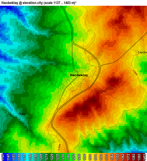
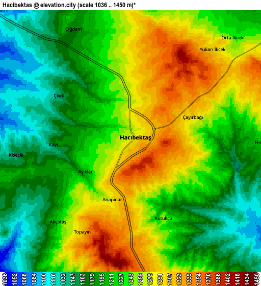
Below is the Elevation map of Hacıbektaş, which displays elevation range with different colors. Scale of the first map is from 1137 to 1403 m (3730 to 4603 ft) with average elevation of 1273.6 meters (=4178 ft) [note 1]
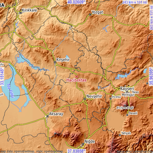
These maps also provides idea of topography and contour of this city, they are displayed at different zoom levels. More info about maps, scale and edge coordinates you can find below images.
| \ | Map #1 | Map #2 | Topo.Map |
| Scale [m] | 1137..1403 m | 1036..1450 m | × |
| Scale [ft] | 3730..4603 ft | 3399..4757 ft | × |
| Average | 1273.6 m = 4178 ft | 1229 m = 4032 ft | × |
| Width | 7.6 km = 4.7 mi | 15.2 km = 9.4 mi | 243.2 km = 151.1 mi |
| Height | 7.6 km = 4.7 mi | 15.2 km = 9.4 mi | 243.2 km = 151.1 mi |
| ↑Max Latitude | 38.974942° | 39.009098° | 40.02609° |
| Latitude at center | 38.94077° | 38.94077° | 38.94077° |
| ↓Min Latitude | 38.906581° | 38.872376° | 37.83858° |
| ← Min Longitude | 34.513755° | 34.469809° | 33.15145° |
| Longitude center | 34.5577° | 34.5577° | 34.5577° |
| →Max Longitude | 34.601645° | 34.645591° | 35.96395° |
Nearby cities:
Cities around Hacıbektaş sort by population:
• Kırşehir elevation 997 m
40.9 km,  303°
303°
• Nevşehir 1213 m
37.6 km,  159°
159°
• Mucur 1084 m
20.2 km,  311°
311°
• Avanos 927 m
35.5 km,  135°
135°
• Gülşehir 913 m
22.4 km, 164°
• Acıgöl 1246 m
43.6 km,  185°
185°
• Göreme 1114 m
40.9 km, 143°
• Karahasanlı 1019 m
42 km,  19°
19°
• Kozaklı 1042 m
40.2 km,  39°
39°
• Özonak 1187 m
28.4 km,  120°
120°
• Topaklı 1206 m
24.3 km,  72°
72°
• Salanda 1018 m
13 km, 189°
Multilingual:
 En español:
Hacıbektaş elevación 1284 m.
 En France:
Hacıbektaş élévation 1284 m.
 Auf Deutsch:
Hacıbektaş höhe über dem Meeresspiegel ist 1284 m.

Sources and notes:
- [note 1] Map square and city borders are not equal. Map elevation data is calculated only from area inside that square.
- [src 1] Elevation data from geonames database provided with same terms of usage.
- [src 2] The elevation map of Hacıbektaş is generated using elevation data from NASA's 3 arcsec (90m) resolution SRTM data.
- [src 3] Base (background) map © OpenStreetMap contributors tiles are generated by Geofabrik and OpenTopoMap.
Copyright & License:
This Hacıbektaş Elevation Map is licensed under CC BY-SA. You may reuse any part from this page, if you give a proper credit by linking to this URL:
 More info on terms of use page.