Mucur elevation
Mucur (Kırşehir), Turkey elevation is 1084 meters and Mucur elevation in feet is 3556 ft above sea level [src 1]. Mucur is a seat of a second-order administrative division (feature code) with elevation that is 361 meters (1184 ft) bigger than average city elevation in Turkey.
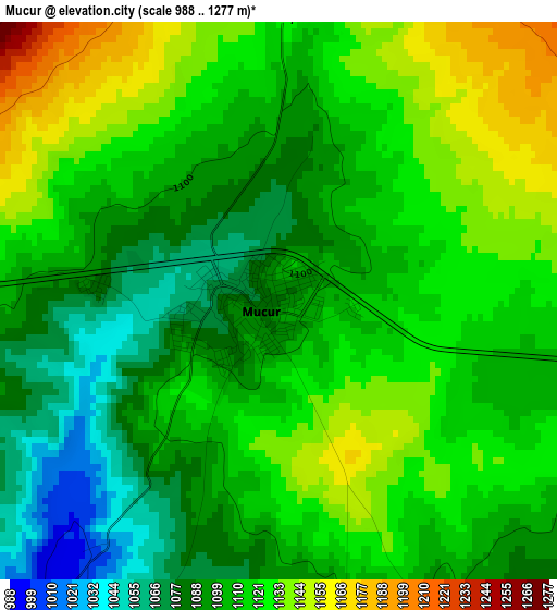
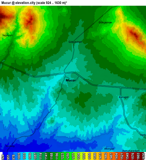
Below is the Elevation map of Mucur, which displays elevation range with different colors. Scale of the first map is from 988 to 1277 m (3241 to 4190 ft) with average elevation of 1110.9 meters (=3645 ft) [note 1]
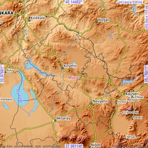
These maps also provides idea of topography and contour of this city, they are displayed at different zoom levels. More info about maps, scale and edge coordinates you can find below images.
| \ | Map #1 | Map #2 | Topo.Map |
| Scale [m] | 988..1277 m | 924..1630 m | × |
| Scale [ft] | 3241..4190 ft | 3031..5348 ft | × |
| Average | 1110.9 m = 3645 ft | 1134.7 m = 3723 ft | × |
| Width | 7.59 km = 4.7 mi | 15.18 km = 9.4 mi | 242.8 km = 150.9 mi |
| Height | 7.59 km = 4.7 mi | 15.18 km = 9.4 mi | 242.8 km = 150.9 mi |
| ↑Max Latitude | 39.095584° | 39.129681° | 40.14492° |
| Latitude at center | 39.06147° | 39.06147° | 39.06147° |
| ↓Min Latitude | 39.02734° | 38.993193° | 37.96114° |
| ← Min Longitude | 34.338915° | 34.294969° | 32.97661° |
| Longitude center | 34.38286° | 34.38286° | 34.38286° |
| →Max Longitude | 34.426805° | 34.470751° | 35.78911° |
Nearby cities:
Cities around Mucur sort by population:
• Kırşehir elevation 997 m
21.1 km,  296°
296°
• Ortaköy 1226 m
46.8 km,  219°
219°
• Gülşehir 913 m
40.9 km,  149°
149°
• Hacıbektaş 1284 m
20.2 km,  131°
131°
• Ağaçören 1232 m
45.3 km,  242°
242°
• Balcı 1160 m
44.6 km,  213°
213°
• Kozaklı 1042 m
44.1 km,  66°
66°
• Göllü 1282 m
43.8 km,  350°
350°
• Karahasanlı 1019 m
39.2 km,  48°
48°
• Topaklı 1206 m
38.8 km,  99°
99°
• Salanda 1018 m
29.2 km, 153°
• Boztepe 1181 m
25.4 km,  335°
335°
Multilingual:
 En español:
Mucur elevación 1084 m.
 En France:
Mucur élévation 1084 m.


Sources and notes:
- [note 1] Map square and city borders are not equal. Map elevation data is calculated only from area inside that square.
- [src 1] Elevation data from geonames database provided with same terms of usage.
- [src 2] The elevation map of Mucur is generated using elevation data from NASA's 3 arcsec (90m) resolution SRTM data.
- [src 3] Base (background) map © OpenStreetMap contributors tiles are generated by Geofabrik and OpenTopoMap.
Copyright & License:
This Mucur Elevation Map is licensed under CC BY-SA. You may reuse any part from this page, if you give a proper credit by linking to this URL:
 More info on terms of use page.