Yerköy elevation
Yerköy (Yozgat), Turkey elevation is 770 meters and Yerköy elevation in feet is 2526 ft above sea level [src 1]. Yerköy is a seat of a second-order administrative division (feature code) with elevation that is 47 meters (154 ft) bigger than average city elevation in Turkey.
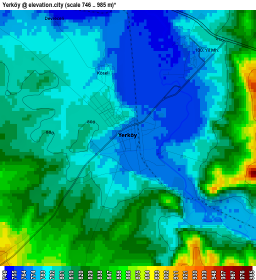
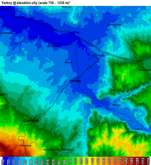
Below is the Elevation map of Yerköy, which displays elevation range with different colors. Scale of the first map is from 746 to 985 m (2448 to 3232 ft) with average elevation of 802.8 meters (=2634 ft) [note 1]
These maps also provides idea of topography and contour of this city, they are displayed at different zoom levels. More info about maps, scale and edge coordinates you can find below images.
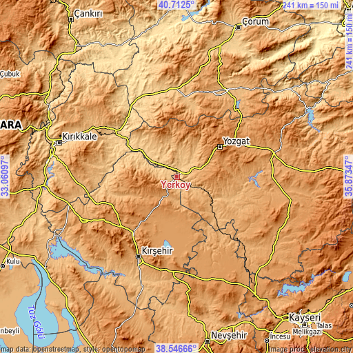
| \ | Map #1 | Map #2 | Topo.Map |
| Scale [m] | 746..985 m | 730..1335 m | × |
| Scale [ft] | 2448..3232 ft | 2395..4380 ft | × |
| Average | 802.8 m = 2634 ft | 864.5 m = 2836 ft | × |
| Width | 7.53 km = 4.7 mi | 15.05 km = 9.4 mi | 240.8 km = 149.6 mi |
| Height | 7.53 km = 4.7 mi | 15.05 km = 9.4 mi | 240.8 km = 149.6 mi |
| ↑Max Latitude | 39.671894° | 39.705711° | 40.7125° |
| Latitude at center | 39.63806° | 39.63806° | 39.63806° |
| ↓Min Latitude | 39.60421° | 39.570343° | 38.54666° |
| ← Min Longitude | 34.423275° | 34.379329° | 33.06097° |
| Longitude center | 34.46722° | 34.46722° | 34.46722° |
| →Max Longitude | 34.511165° | 34.555111° | 35.87347° |
Nearby cities:
Cities around Yerköy sort by population:
• Yozgat elevation 1290 m
35.2 km,  54°
54°
• Şefaatlı 925 m
28.9 km,  120°
120°
• Boztepe 1181 m
44.6 km,  203°
203°
• Boğazkale 1013 m
44.4 km,  15°
15°
• Karahasanlı 1019 m
43.8 km,  150°
150°
• Osmanpaşa 1049 m
42.6 km,  91°
91°
• Salmanlı 1020 m
34.5 km,  328°
328°
• Akçakent 1395 m
31.8 km,  266°
266°
• Kösefakılı 1355 m
28.8 km,  260°
260°
• Göllü 1282 m
25.4 km,  214°
214°
• Musabeyli 956 m
25.4 km,  31°
31°
• Çiçekdağı 957 m
6.1 km,  235°
235°
Multilingual:
 En español:
Yerköy elevación 770 m.
 En France:
Yerköy élévation 770 m.


Sources and notes:
- [note 1] Map square and city borders are not equal. Map elevation data is calculated only from area inside that square.
- [src 1] Elevation data from geonames database provided with same terms of usage.
- [src 2] The elevation map of Yerköy is generated using elevation data from NASA's 3 arcsec (90m) resolution SRTM data.
- [src 3] Base (background) map © OpenStreetMap contributors tiles are generated by Geofabrik and OpenTopoMap.
Copyright & License:
This Yerköy Elevation Map is licensed under CC BY-SA. You may reuse any part from this page, if you give a proper credit by linking to this URL:
 More info on terms of use page.