Keçiborlu elevation
Keçiborlu (Isparta), Turkey elevation is 994 meters and Keçiborlu elevation in feet is 3261 ft above sea level [src 1]. Keçiborlu is a seat of a second-order administrative division (feature code) with elevation that is 271 meters (889 ft) bigger than average city elevation in Turkey.
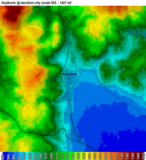
Below is the Elevation map of Keçiborlu, which displays elevation range with different colors. Scale of the first map is from 925 to 1427 m (3035 to 4682 ft) with average elevation of 1099.3 meters (=3607 ft) [note 1]
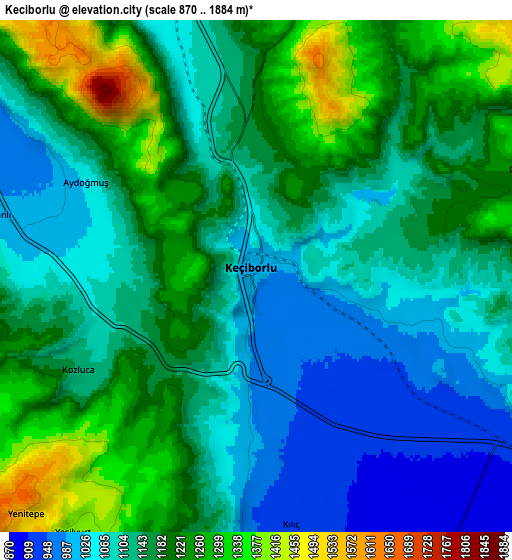
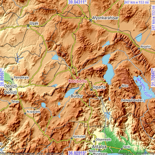
These maps also provides idea of topography and contour of this city, they are displayed at different zoom levels. More info about maps, scale and edge coordinates you can find below images.
| \ | Map #1 | Map #2 | Topo.Map |
| Scale [m] | 925..1427 m | 870..1884 m | × |
| Scale [ft] | 3035..4682 ft | 2854..6181 ft | × |
| Average | 1099.3 m = 3607 ft | 1147 m = 3763 ft | × |
| Width | 7.71 km = 4.8 mi | 15.41 km = 9.6 mi | 246.6 km = 153.2 mi |
| Height | 7.71 km = 4.8 mi | 15.41 km = 9.6 mi | 246.6 km = 153.2 mi |
| ↑Max Latitude | 37.977148° | 38.01178° | 39.04311° |
| Latitude at center | 37.9425° | 37.9425° | 37.9425° |
| ↓Min Latitude | 37.907835° | 37.873154° | 36.82515° |
| ← Min Longitude | 30.258275° | 30.214329° | 28.89597° |
| Longitude center | 30.30222° | 30.30222° | 30.30222° |
| →Max Longitude | 30.346165° | 30.390111° | 31.70847° |
Nearby cities:
Cities around Keçiborlu sort by population:
• Isparta elevation 1069 m
29.6 km,  132°
132°
• Burdur 956 m
24.7 km,  182°
182°
• Dinar 863 m
18.1 km,  318°
318°
• Senirkent 1024 m
28.1 km,  50°
50°
• Gönen 1040 m
18.4 km,  85°
85°
• Atabey 1039 m
29.5 km, 88°
• Uluborlu 1050 m
19.9 km,  40°
40°
• Başmakçı 858 m
26 km,  258°
258°
• Evciler 907 m
38 km,  286°
286°
• Kızılören 1111 m
37.5 km,  339°
339°
• Haydarlı 1174 m
36 km,  11°
11°
• Dombay 1038 m
24.9 km, 340°
Multilingual:
 En español:
Keçiborlu elevación 994 m.
 En France:
Keçiborlu élévation 994 m.
 Auf Deutsch:
Keçiborlu höhe über dem Meeresspiegel ist 994 m.

Sources and notes:
- [note 1] Map square and city borders are not equal. Map elevation data is calculated only from area inside that square.
- [src 1] Elevation data from geonames database provided with same terms of usage.
- [src 2] The elevation map of Keçiborlu is generated using elevation data from NASA's 3 arcsec (90m) resolution SRTM data.
- [src 3] Base (background) map © OpenStreetMap contributors tiles are generated by Geofabrik and OpenTopoMap.
Copyright & License:
This Keçiborlu Elevation Map is licensed under CC BY-SA. You may reuse any part from this page, if you give a proper credit by linking to this URL:
 More info on terms of use page.