Başmakçı elevation
Başmakçı (Afyonkarahisar), Turkey elevation is 858 meters and Başmakçı elevation in feet is 2815 ft above sea level [src 1]. Başmakçı is a seat of a second-order administrative division (feature code) with elevation that is 135 meters (443 ft) bigger than average city elevation in Turkey.
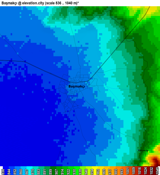
Below is the Elevation map of Başmakçı, which displays elevation range with different colors. Scale of the first map is from 836 to 1040 m (2743 to 3412 ft) with average elevation of 866.8 meters (=2844 ft) [note 1]
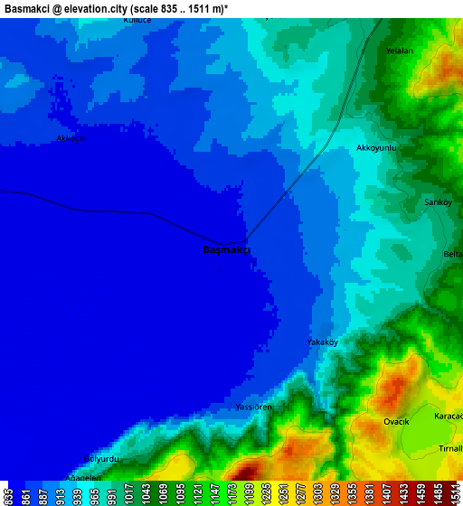
These maps also provides idea of topography and contour of this city, they are displayed at different zoom levels. More info about maps, scale and edge coordinates you can find below images.
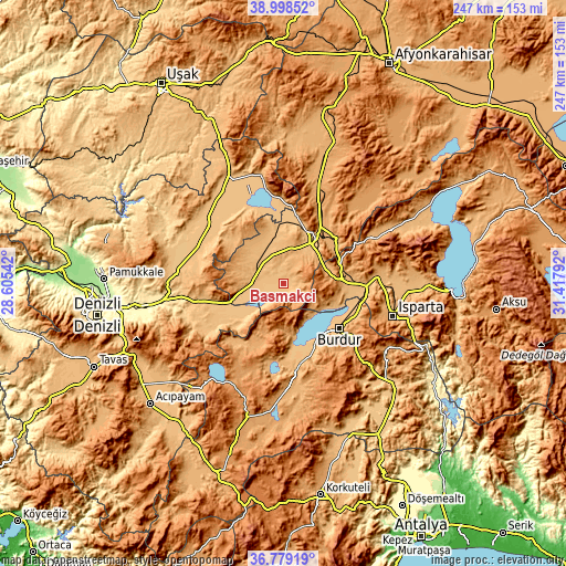
| \ | Map #1 | Map #2 | Topo.Map |
| Scale [m] | 836..1040 m | 835..1511 m | × |
| Scale [ft] | 2743..3412 ft | 2740..4957 ft | × |
| Average | 866.8 m = 2844 ft | 948.1 m = 3111 ft | × |
| Width | 7.71 km = 4.8 mi | 15.42 km = 9.6 mi | 246.8 km = 153.4 mi |
| Height | 7.71 km = 4.8 mi | 15.42 km = 9.6 mi | 246.8 km = 153.4 mi |
| ↑Max Latitude | 37.93189° | 37.966543° | 38.99852° |
| Latitude at center | 37.89722° | 37.89722° | 37.89722° |
| ↓Min Latitude | 37.862534° | 37.827832° | 36.77919° |
| ← Min Longitude | 29.967725° | 29.923779° | 28.60542° |
| Longitude center | 30.01167° | 30.01167° | 30.01167° |
| →Max Longitude | 30.055615° | 30.099561° | 31.41792° |
Nearby cities:
Cities around Başmakçı sort by population:
• Burdur elevation 956 m
31.4 km,  128°
128°
• Dinar 863 m
23 km,  35°
35°
• Keçiborlu 994 m
26 km,  78°
78°
• Baklan 968 m
36.4 km,  284°
284°
• Dazkırı 882 m
13.5 km, 280°
• Evciler 907 m
19.4 km,  325°
325°
• Bozkurt 861 m
36.2 km,  257°
257°
• Kızılören 1111 m
42 km,  16°
16°
• Homa 916 m
38.1 km,  356°
356°
• İshaklı 823 m
33.6 km,  0°
0°
• Dombay 1038 m
33.4 km,  31°
31°
• Çardak 878 m
31.1 km, 255°
Multilingual:
 En español:
Başmakçı elevación 858 m.
 En France:
Başmakçı élévation 858 m.
 Auf Deutsch:
Başmakçı höhe über dem Meeresspiegel ist 858 m.

Sources and notes:
- [note 1] Map square and city borders are not equal. Map elevation data is calculated only from area inside that square.
- [src 1] Elevation data from geonames database provided with same terms of usage.
- [src 2] The elevation map of Başmakçı is generated using elevation data from NASA's 3 arcsec (90m) resolution SRTM data.
- [src 3] Base (background) map © OpenStreetMap contributors tiles are generated by Geofabrik and OpenTopoMap.
Copyright & License:
This Başmakçı Elevation Map is licensed under CC BY-SA. You may reuse any part from this page, if you give a proper credit by linking to this URL:
 More info on terms of use page.