Gönen elevation
Gönen (Isparta), Turkey elevation is 1040 meters and Gönen elevation in feet is 3412 ft above sea level [src 1]. Gönen is a seat of a second-order administrative division (feature code) with elevation that is 317 meters (1040 ft) bigger than average city elevation in Turkey.
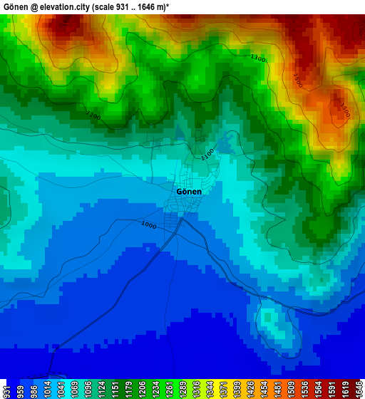
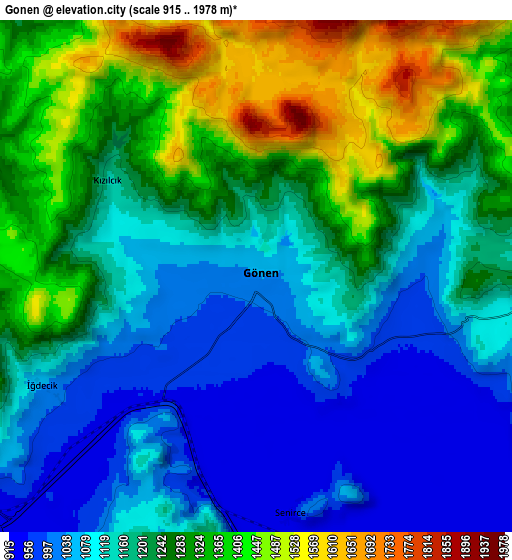
Below is the Elevation map of Gönen, which displays elevation range with different colors. Scale of the first map is from 931 to 1646 m (3054 to 5400 ft) with average elevation of 1124.5 meters (=3689 ft) [note 1]
These maps also provides idea of topography and contour of this city, they are displayed at different zoom levels. More info about maps, scale and edge coordinates you can find below images.
| \ | Map #1 | Map #2 | Topo.Map |
| Scale [m] | 931..1646 m | 915..1978 m | × |
| Scale [ft] | 3054..5400 ft | 3002..6490 ft | × |
| Average | 1124.5 m = 3689 ft | 1204.9 m = 3953 ft | × |
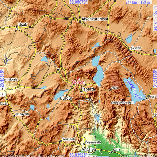
| Width | 7.71 km = 4.8 mi | 15.41 km = 9.6 mi | 246.6 km = 153.2 mi |
| Height | 7.71 km = 4.8 mi | 15.41 km = 9.6 mi | 246.6 km = 153.2 mi |
| ↑Max Latitude | 37.991032° | 38.025657° | 39.05679° |
| Latitude at center | 37.95639° | 37.95639° | 37.95639° |
| ↓Min Latitude | 37.921732° | 37.887057° | 36.83925° |
| ← Min Longitude | 30.467455° | 30.423509° | 29.10515° |
| Longitude center | 30.5114° | 30.5114° | 30.5114° |
| →Max Longitude | 30.555345° | 30.599291° | 31.91765° |
Nearby cities:
Cities around Gönen sort by population:
• Isparta elevation 1069 m
21.6 km,  170°
170°
• Burdur 956 m
32.6 km,  216°
216°
• Dinar 863 m
32.6 km,  291°
291°
• Eğirdir 925 m
31.1 km,  106°
106°
• Senirkent 1024 m
16.8 km,  11°
11°
• Atabey 1039 m
11.2 km,  93°
93°
• Uluborlu 1050 m
14.6 km,  338°
338°
• Keçiborlu 994 m
18.4 km,  265°
265°
• Ağlasun 1133 m
34.2 km,  176°
176°
• Anamas 2130 m
33 km,  129°
129°
• Dombay 1038 m
34.4 km,  309°
309°
• Barla 1108 m
24.7 km,  73°
73°
Multilingual:
 En español:
Gönen elevación 1040 m.
 En France:
Gönen élévation 1040 m.


Sources and notes:
- [note 1] Map square and city borders are not equal. Map elevation data is calculated only from area inside that square.
- [src 1] Elevation data from geonames database provided with same terms of usage.
- [src 2] The elevation map of Gönen is generated using elevation data from NASA's 3 arcsec (90m) resolution SRTM data.
- [src 3] Base (background) map © OpenStreetMap contributors tiles are generated by Geofabrik and OpenTopoMap.
Copyright & License:
This Gönen Elevation Map is licensed under CC BY-SA. You may reuse any part from this page, if you give a proper credit by linking to this URL:
 More info on terms of use page.