Uluborlu elevation
Uluborlu (Isparta), Turkey elevation is 1050 meters and Uluborlu elevation in feet is 3445 ft above sea level [src 1]. Uluborlu is a seat of a second-order administrative division (feature code) with elevation that is 327 meters (1073 ft) bigger than average city elevation in Turkey.
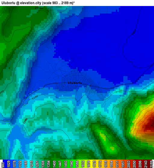
Below is the Elevation map of Uluborlu, which displays elevation range with different colors. Scale of the first map is from 983 to 2189 m (3225 to 7182 ft) with average elevation of 1194.3 meters (=3918 ft) [note 1]
These maps also provides idea of topography and contour of this city, they are displayed at different zoom levels. More info about maps, scale and edge coordinates you can find below images.
| \ | Map #1 | Map #2 | Topo.Map |
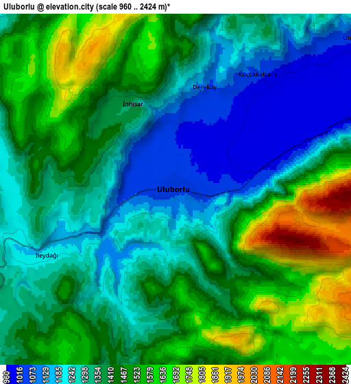
| Scale [m] | 983..2189 m | 960..2424 m | × |
| Scale [ft] | 3225..7182 ft | 3150..7953 ft | × |
| Average | 1194.3 m = 3918 ft | 1393.2 m = 4571 ft | × |
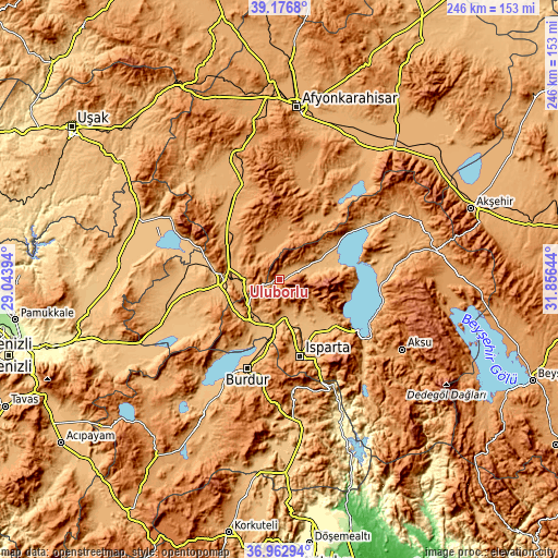
| Width | 7.69 km = 4.8 mi | 15.39 km = 9.6 mi | 246.2 km = 153 mi |
| Height | 7.69 km = 4.8 mi | 15.39 km = 9.6 mi | 246.2 km = 153 mi |
| ↑Max Latitude | 38.112834° | 38.147402° | 39.1768° |
| Latitude at center | 38.07825° | 38.07825° | 38.07825° |
| ↓Min Latitude | 38.043649° | 38.009032° | 36.96294° |
| ← Min Longitude | 30.406245° | 30.362299° | 29.04394° |
| Longitude center | 30.45019° | 30.45019° | 30.45019° |
| →Max Longitude | 30.494135° | 30.538081° | 31.85644° |
Nearby cities:
Cities around Uluborlu sort by population:
• Isparta elevation 1069 m
36 km,  165°
165°
• Dinar 863 m
25 km,  266°
266°
• Eğirdir 925 m
41.8 km,  122°
122°
• Senirkent 1024 m
9.1 km,  71°
71°
• Gönen 1040 m
14.6 km,  158°
158°
• Atabey 1039 m
21.8 km,  130°
130°
• Keçiborlu 994 m
19.9 km,  220°
220°
• Kızılören 1111 m
32.9 km,  307°
307°
• İshaklı 823 m
40.5 km,  289°
289°
• Barla 1108 m
29.9 km,  103°
103°
• Dombay 1038 m
22.7 km, 291°
• Haydarlı 1174 m
20.9 km,  344°
344°
Multilingual:
 En español:
Uluborlu elevación 1050 m.
 En France:
Uluborlu élévation 1050 m.
 Auf Deutsch:
Uluborlu höhe über dem Meeresspiegel ist 1050 m.

Sources and notes:
- [note 1] Map square and city borders are not equal. Map elevation data is calculated only from area inside that square.
- [src 1] Elevation data from geonames database provided with same terms of usage.
- [src 2] The elevation map of Uluborlu is generated using elevation data from NASA's 3 arcsec (90m) resolution SRTM data.
- [src 3] Base (background) map © OpenStreetMap contributors tiles are generated by Geofabrik and OpenTopoMap.
Copyright & License:
This Uluborlu Elevation Map is licensed under CC BY-SA. You may reuse any part from this page, if you give a proper credit by linking to this URL:
 More info on terms of use page.