Poyraz elevation
Poyraz (Elazığ), Turkey elevation is 1079 meters and Poyraz elevation in feet is 3540 ft above sea level [src 1]. Poyraz is a seat of a third-order administrative division (feature code) with elevation that is 356 meters (1168 ft) bigger than average city elevation in Turkey.
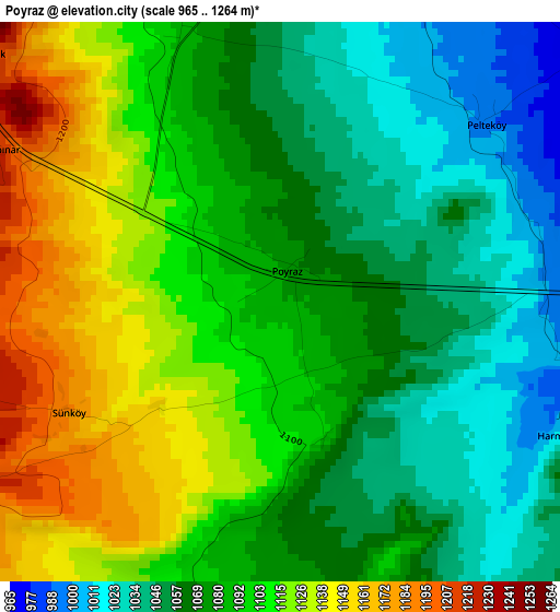
Below is the Elevation map of Poyraz, which displays elevation range with different colors. Scale of the first map is from 965 to 1264 m (3166 to 4147 ft) with average elevation of 1085.6 meters (=3562 ft) [note 1]
These maps also provides idea of topography and contour of this city, they are displayed at different zoom levels. More info about maps, scale and edge coordinates you can find below images.
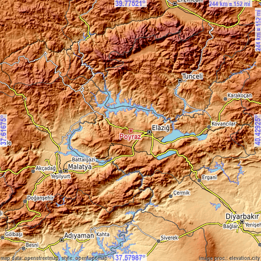
| \ | Map #1 | Topo.Map |
| Scale [m] | 965..1264 m | × |
| Scale [ft] | 3166..4147 ft | × |
| Average | 1085.6 m = 3562 ft | × |
| Width | 7.63 km = 4.7 mi | 244.1 km = 151.7 mi |
| Height | 7.63 km = 4.7 mi | 244.1 km = 151.7 mi |
| ↑Max Latitude | 38.720255° | 39.77521° |
| Latitude at center | 38.68596° | 38.68596° |
| ↓Min Latitude | 38.651649° | 37.57987° |
| ← Min Longitude | 38.979055° | 37.61675° |
| Longitude center | 39.023° | 39.023° |
| →Max Longitude | 39.066945° | 40.42925° |
Nearby cities:
Cities around Poyraz sort by population:
• Elazığ elevation 1062 m
17.4 km,  94°
94°
• Baskil 1206 m
22.2 km,  233°
233°
• Pertek 1058 m
32.8 km,  52°
52°
• Keban 746 m
27.7 km,  295°
295°
• Sivrice 1298 m
36.8 km,  137°
137°
• Kale 761 m
37.2 km,  216°
216°
• Akçapınar 874 m
29.9 km,  346°
346°
• Mollakendi 863 m
29.5 km,  114°
114°
• Gözeli 1560 m
29.2 km,  174°
174°
• Harput 1312 m
19.1 km,  84°
84°
• Hankendi 1160 m
13.4 km, 167°
• Hıdırbaba 1124 m
9.9 km,  336°
336°
Multilingual:
 En español:
Poyraz elevación 1079 m.
 En France:
Poyraz élévation 1079 m.


Sources and notes:
- [note 1] Map square and city borders are not equal. Map elevation data is calculated only from area inside that square.
- [src 1] Elevation data from geonames database provided with same terms of usage.
- [src 2] The elevation map of Poyraz is generated using elevation data from NASA's 3 arcsec (90m) resolution SRTM data.
- [src 3] Base (background) map © OpenStreetMap contributors tiles are generated by Geofabrik and OpenTopoMap.
Copyright & License:
This Poyraz Elevation Map is licensed under CC BY-SA. You may reuse any part from this page, if you give a proper credit by linking to this URL:
 More info on terms of use page.