Harput elevation
Harput (Elazığ), Turkey elevation is 1312 meters and Harput elevation in feet is 4304 ft above sea level [src 1]. Harput is a seat of a third-order administrative division (feature code) with elevation that is 589 meters (1932 ft) bigger than average city elevation in Turkey.
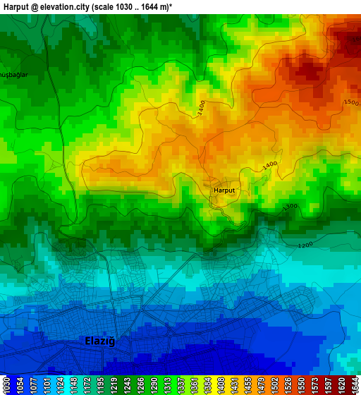
Below is the Elevation map of Harput, which displays elevation range with different colors. Scale of the first map is from 1030 to 1644 m (3379 to 5394 ft) with average elevation of 1261 meters (=4137 ft) [note 1]
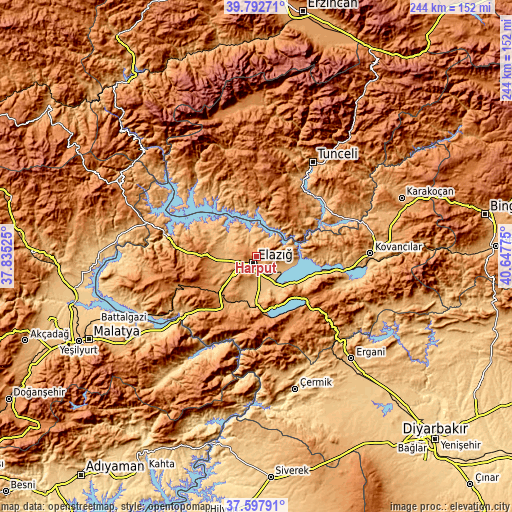
These maps also provides idea of topography and contour of this city, they are displayed at different zoom levels. More info about maps, scale and edge coordinates you can find below images.
| \ | Map #1 | Topo.Map |
| Scale [m] | 1030..1644 m | × |
| Scale [ft] | 3379..5394 ft | × |
| Average | 1261 m = 4137 ft | × |
| Width | 7.63 km = 4.7 mi | 244 km = 151.6 mi |
| Height | 7.63 km = 4.7 mi | 244 km = 151.6 mi |
| ↑Max Latitude | 38.738016° | 39.79271° |
| Latitude at center | 38.70373° | 38.70373° |
| ↓Min Latitude | 38.669427° | 37.59791° |
| ← Min Longitude | 39.197555° | 37.83525° |
| Longitude center | 39.2415° | 39.2415° |
| →Max Longitude | 39.285445° | 40.64775° |
Nearby cities:
Cities around Harput sort by population:
• Elazığ elevation 1062 m
3.6 km,  205°
205°
• Pertek 1058 m
19.3 km,  21°
21°
• Sivrice 1298 m
29.7 km,  168°
168°
• Çaybağı 869 m
34.9 km,  66°
66°
• Çaybağı 925 m
32.9 km,  91°
91°
• Dere 1170 m
31.5 km,  9°
9°
• İçme 954 m
28.7 km,  110°
110°
• Pınarlar 1282 m
27.6 km,  46°
46°
• Hıdırbaba 1124 m
24 km,  287°
287°
• Hankendi 1160 m
21.9 km,  226°
226°
• Poyraz 1079 m
19.1 km,  264°
264°
• Mollakendi 863 m
16.1 km,  150°
150°
Multilingual:
 En español:
Harput elevación 1312 m.
 En France:
Harput élévation 1312 m.


Sources and notes:
- [note 1] Map square and city borders are not equal. Map elevation data is calculated only from area inside that square.
- [src 1] Elevation data from geonames database provided with same terms of usage.
- [src 2] The elevation map of Harput is generated using elevation data from NASA's 3 arcsec (90m) resolution SRTM data.
- [src 3] Base (background) map © OpenStreetMap contributors tiles are generated by Geofabrik and OpenTopoMap.
Copyright & License:
This Harput Elevation Map is licensed under CC BY-SA. You may reuse any part from this page, if you give a proper credit by linking to this URL:
 More info on terms of use page.