Pertek elevation
Pertek (Tunceli), Turkey elevation is 1058 meters and Pertek elevation in feet is 3471 ft above sea level [src 1]. Pertek is a seat of a second-order administrative division (feature code) with elevation that is 335 meters (1099 ft) bigger than average city elevation in Turkey.
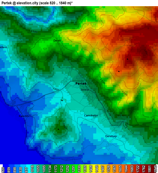
Below is the Elevation map of Pertek, which displays elevation range with different colors. Scale of the first map is from 820 to 1840 m (2690 to 6037 ft) with average elevation of 1165.6 meters (=3824 ft) [note 1]
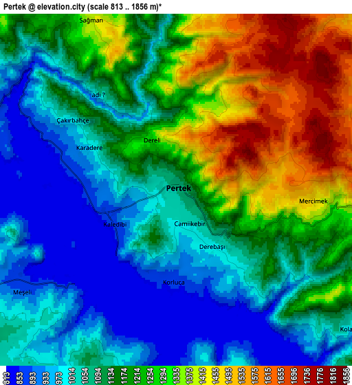
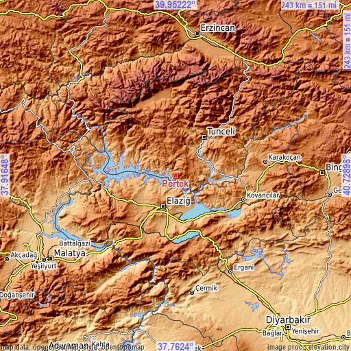
These maps also provides idea of topography and contour of this city, they are displayed at different zoom levels. More info about maps, scale and edge coordinates you can find below images.
| \ | Map #1 | Map #2 | Topo.Map |
| Scale [m] | 820..1840 m | 813..1856 m | × |
| Scale [ft] | 2690..6037 ft | 2667..6089 ft | × |
| Average | 1165.6 m = 3824 ft | 1160.4 m = 3807 ft | × |
| Width | 7.61 km = 4.7 mi | 15.22 km = 9.5 mi | 243.5 km = 151.3 mi |
| Height | 7.61 km = 4.7 mi | 15.22 km = 9.5 mi | 243.5 km = 151.3 mi |
| ↑Max Latitude | 38.899948° | 38.93414° | 39.95222° |
| Latitude at center | 38.86574° | 38.86574° | 38.86574° |
| ↓Min Latitude | 38.831515° | 38.797274° | 37.7624° |
| ← Min Longitude | 39.278785° | 39.234839° | 37.91648° |
| Longitude center | 39.32273° | 39.32273° | 39.32273° |
| →Max Longitude | 39.366675° | 39.410621° | 40.72898° |
Nearby cities:
Cities around Pertek sort by population:
• Elazığ elevation 1062 m
23 km,  202°
202°
• Hozat 1524 m
27.9 km,  339°
339°
• Mazgirt 1392 m
29.4 km,  54°
54°
• Çaybağı 925 m
32.1 km,  126°
126°
• Hıdırbaba 1124 m
31.9 km,  249°
249°
• Akpazar 879 m
30 km,  94°
94°
• Çaybağı 869 m
25.3 km,  99°
99°
• Çağlarca 1266 m
24.8 km,  320°
320°
• Çiçekli 1119 m
22.5 km,  21°
21°
• Harput 1312 m
19.3 km, 201°
• Dere 1170 m
13.2 km,  351°
351°
• Pınarlar 1282 m
13 km, 85°
Multilingual:
 En español:
Pertek elevación 1058 m.
 En France:
Pertek élévation 1058 m.


Sources and notes:
- [note 1] Map square and city borders are not equal. Map elevation data is calculated only from area inside that square.
- [src 1] Elevation data from geonames database provided with same terms of usage.
- [src 2] The elevation map of Pertek is generated using elevation data from NASA's 3 arcsec (90m) resolution SRTM data.
- [src 3] Base (background) map © OpenStreetMap contributors tiles are generated by Geofabrik and OpenTopoMap.
Copyright & License:
This Pertek Elevation Map is licensed under CC BY-SA. You may reuse any part from this page, if you give a proper credit by linking to this URL:
 More info on terms of use page.