Kale elevation
Kale (Malatya), Turkey elevation is 761 meters and Kale elevation in feet is 2497 ft above sea level [src 1]. Kale is a seat of a second-order administrative division (feature code) with elevation that is 38 meters (125 ft) bigger than average city elevation in Turkey.
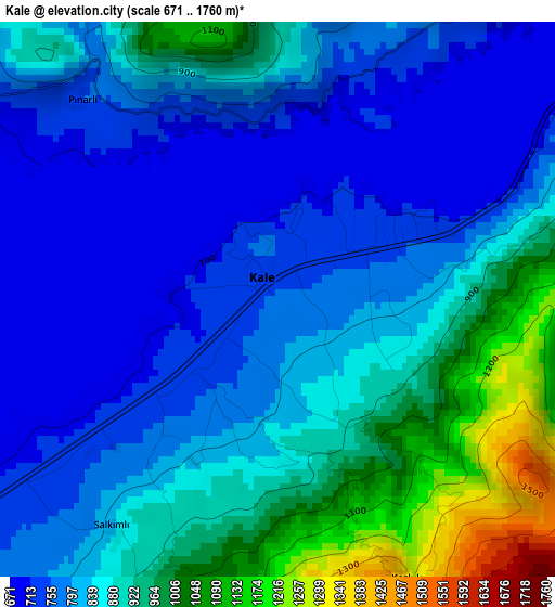
Below is the Elevation map of Kale, which displays elevation range with different colors. Scale of the first map is from 671 to 1760 m (2201 to 5774 ft) with average elevation of 847.1 meters (=2779 ft) [note 1]
These maps also provides idea of topography and contour of this city, they are displayed at different zoom levels. More info about maps, scale and edge coordinates you can find below images.
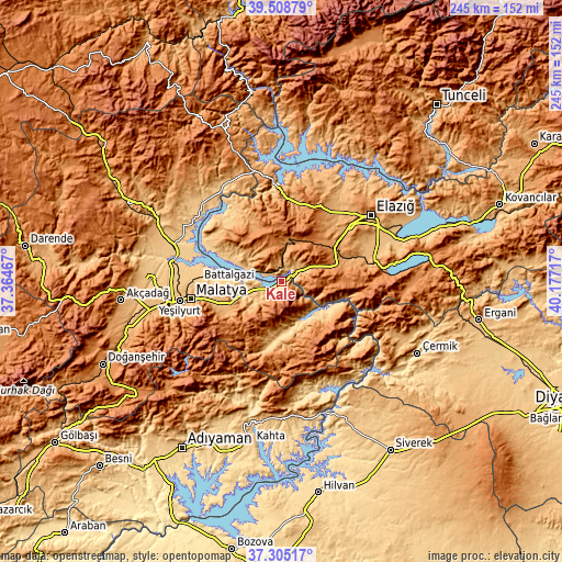
| \ | Map #1 | Topo.Map |
| Scale [m] | 671..1760 m | × |
| Scale [ft] | 2201..5774 ft | × |
| Average | 847.1 m = 2779 ft | × |
| Width | 7.66 km = 4.8 mi | 245 km = 152.2 mi |
| Height | 7.66 km = 4.8 mi | 245 km = 152.2 mi |
| ↑Max Latitude | 38.449804° | 39.50879° |
| Latitude at center | 38.41538° | 38.41538° |
| ↓Min Latitude | 38.380939° | 37.30517° |
| ← Min Longitude | 38.726975° | 37.36467° |
| Longitude center | 38.77092° | 38.77092° |
| →Max Longitude | 38.814865° | 40.17717° |
Nearby cities:
Cities around Kale sort by population:
• Malatya elevation 963 m
40.3 km,  259°
259°
• Baskil 1206 m
17.5 km,  13°
13°
• Doğanyol 930 m
25.9 km,  117°
117°
• Poyraz 1079 m
37.2 km,  36°
36°
• Battalgazi 784 m
35.9 km,  271°
271°
• Tepehan 1397 m
33.3 km,  186°
186°
• Aydınlar 1273 m
30.5 km,  318°
318°
• Hankendi 1160 m
30.2 km,  55°
55°
• Pütürge 1205 m
25.3 km,  161°
161°
• Gözeli 1560 m
25 km,  87°
87°
• Çolaklı 1118 m
23.7 km,  247°
247°
• Kuşsarayı 796 m
8.9 km,  296°
296°
Multilingual:
 En español:
Kale elevación 761 m.
 En France:
Kale élévation 761 m.


Sources and notes:
- [note 1] Map square and city borders are not equal. Map elevation data is calculated only from area inside that square.
- [src 1] Elevation data from geonames database provided with same terms of usage.
- [src 2] The elevation map of Kale is generated using elevation data from NASA's 3 arcsec (90m) resolution SRTM data.
- [src 3] Base (background) map © OpenStreetMap contributors tiles are generated by Geofabrik and OpenTopoMap.
Copyright & License:
This Kale Elevation Map is licensed under CC BY-SA. You may reuse any part from this page, if you give a proper credit by linking to this URL:
 More info on terms of use page.