Aydınlar elevation
Aydınlar (Elazığ), Turkey elevation is 1273 meters and Aydınlar elevation in feet is 4177 ft above sea level [src 1]. Aydınlar is a seat of a third-order administrative division (feature code) with elevation that is 550 meters (1804 ft) bigger than average city elevation in Turkey.
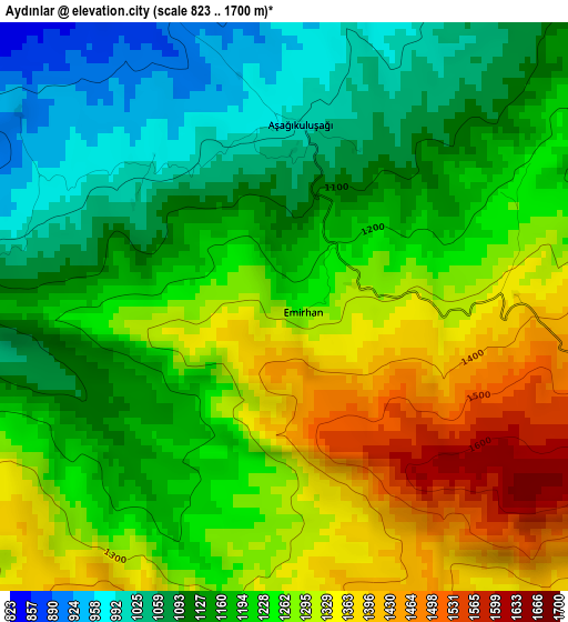
Below is the Elevation map of Aydınlar, which displays elevation range with different colors. Scale of the first map is from 823 to 1700 m (2700 to 5577 ft) with average elevation of 1218.1 meters (=3996 ft) [note 1]
These maps also provides idea of topography and contour of this city, they are displayed at different zoom levels. More info about maps, scale and edge coordinates you can find below images.
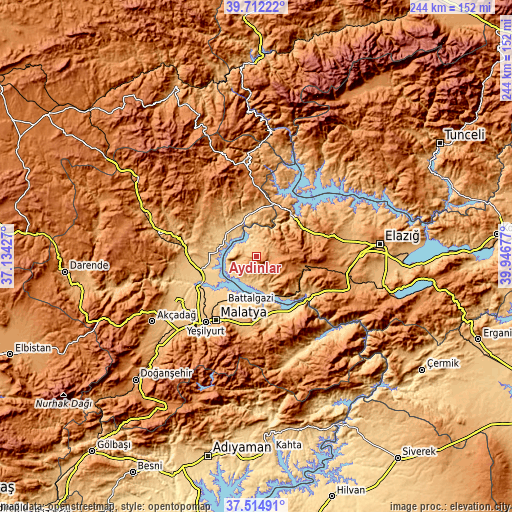
| \ | Map #1 | Topo.Map |
| Scale [m] | 823..1700 m | × |
| Scale [ft] | 2700..5577 ft | × |
| Average | 1218.1 m = 3996 ft | × |
| Width | 7.64 km = 4.7 mi | 244.3 km = 151.8 mi |
| Height | 7.64 km = 4.7 mi | 244.3 km = 151.8 mi |
| ↑Max Latitude | 38.656305° | 39.71222° |
| Latitude at center | 38.62198° | 38.62198° |
| ↓Min Latitude | 38.587638° | 37.51491° |
| ← Min Longitude | 38.496575° | 37.13427° |
| Longitude center | 38.54052° | 38.54052° |
| →Max Longitude | 38.584465° | 39.94677° |
Nearby cities:
Cities around Aydınlar sort by population:
• Malatya elevation 963 m
36 km,  212°
212°
• Baskil 1206 m
24.7 km,  103°
103°
• Keban 746 m
25.5 km,  41°
41°
• Yazıhan 826 m
32.1 km,  264°
264°
• Ağın 944 m
38.1 km,  22°
22°
• Arguvan 1186 m
29.4 km,  305°
305°
• Hıdırbaba 1124 m
41.2 km,  66°
66°
• Çolaklı 1118 m
32.1 km,  183°
183°
• Kale 761 m
30.5 km,  138°
138°
• Battalgazi 784 m
27.2 km,  215°
215°
• Taşdelen 1077 m
24.2 km,  352°
352°
• Kuşsarayı 796 m
22.5 km,  147°
147°
Multilingual:
 En español:
Aydınlar elevación 1273 m.
 En France:
Aydınlar élévation 1273 m.
 Auf Deutsch:
Aydınlar höhe über dem Meeresspiegel ist 1273 m.

Sources and notes:
- [note 1] Map square and city borders are not equal. Map elevation data is calculated only from area inside that square.
- [src 1] Elevation data from geonames database provided with same terms of usage.
- [src 2] The elevation map of Aydınlar is generated using elevation data from NASA's 3 arcsec (90m) resolution SRTM data.
- [src 3] Base (background) map © OpenStreetMap contributors tiles are generated by Geofabrik and OpenTopoMap.
Copyright & License:
This Aydınlar Elevation Map is licensed under CC BY-SA. You may reuse any part from this page, if you give a proper credit by linking to this URL:
 More info on terms of use page.