Yazıhan elevation
Yazıhan (Malatya), Turkey elevation is 826 meters and Yazıhan elevation in feet is 2710 ft above sea level [src 1]. Yazıhan is a seat of a second-order administrative division (feature code) with elevation that is 103 meters (338 ft) bigger than average city elevation in Turkey.
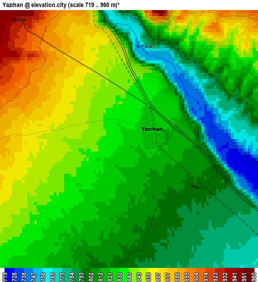
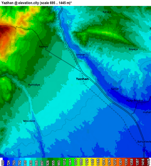
Below is the Elevation map of Yazıhan, which displays elevation range with different colors. Scale of the first map is from 719 to 960 m (2359 to 3150 ft) with average elevation of 826.6 meters (=2712 ft) [note 1]
These maps also provides idea of topography and contour of this city, they are displayed at different zoom levels. More info about maps, scale and edge coordinates you can find below images.
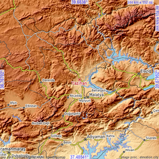
| \ | Map #1 | Map #2 | Topo.Map |
| Scale [m] | 719..960 m | 695..1445 m | × |
| Scale [ft] | 2359..3150 ft | 2280..4741 ft | × |
| Average | 826.6 m = 2712 ft | 857.7 m = 2814 ft | × |
| Width | 7.64 km = 4.7 mi | 15.28 km = 9.5 mi | 244.4 km = 151.9 mi |
| Height | 7.64 km = 4.7 mi | 15.28 km = 9.5 mi | 244.4 km = 151.9 mi |
| ↑Max Latitude | 38.627259° | 38.661582° | 39.6836° |
| Latitude at center | 38.59292° | 38.59292° | 38.59292° |
| ↓Min Latitude | 38.558564° | 38.524192° | 37.48541° |
| ← Min Longitude | 38.129325° | 38.085379° | 36.76702° |
| Longitude center | 38.17327° | 38.17327° | 38.17327° |
| →Max Longitude | 38.217215° | 38.261161° | 39.57952° |
Nearby cities:
Cities around Yazıhan sort by population:
• Malatya elevation 963 m
29.7 km,  155°
155°
• Akçadağ 1067 m
33.3 km,  212°
212°
• Hekimhan 1107 m
32.7 km,  319°
319°
• Yeşilyurt 989 m
33.6 km,  169°
169°
• Arguvan 1186 m
21.6 km,  21°
21°
• Kuşsarayı 796 m
46.7 km,  109°
109°
• Çolaklı 1118 m
41.7 km,  133°
133°
• Taşdelen 1077 m
39.6 km,  46°
46°
• Levent 1356 m
32.7 km,  238°
238°
• Aydınlar 1273 m
32.1 km,  84°
84°
• Kurşunlu 1531 m
28.8 km,  283°
283°
• Battalgazi 784 m
24.8 km,  139°
139°
Multilingual:
 En español:
Yazıhan elevación 826 m.
 En France:
Yazıhan élévation 826 m.


Sources and notes:
- [note 1] Map square and city borders are not equal. Map elevation data is calculated only from area inside that square.
- [src 1] Elevation data from geonames database provided with same terms of usage.
- [src 2] The elevation map of Yazıhan is generated using elevation data from NASA's 3 arcsec (90m) resolution SRTM data.
- [src 3] Base (background) map © OpenStreetMap contributors tiles are generated by Geofabrik and OpenTopoMap.
Copyright & License:
This Yazıhan Elevation Map is licensed under CC BY-SA. You may reuse any part from this page, if you give a proper credit by linking to this URL:
 More info on terms of use page.