Yeşilyurt elevation
Yeşilyurt (Malatya), Turkey elevation is 989 meters and Yeşilyurt elevation in feet is 3245 ft above sea level [src 1]. Yeşilyurt is a seat of a third-order administrative division (feature code) with elevation that is 266 meters (873 ft) bigger than average city elevation in Turkey.
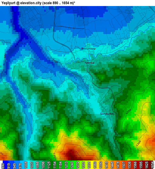
Below is the Elevation map of Yeşilyurt, which displays elevation range with different colors. Scale of the first map is from 890 to 1654 m (2920 to 5427 ft) with average elevation of 1091 meters (=3579 ft) [note 1]
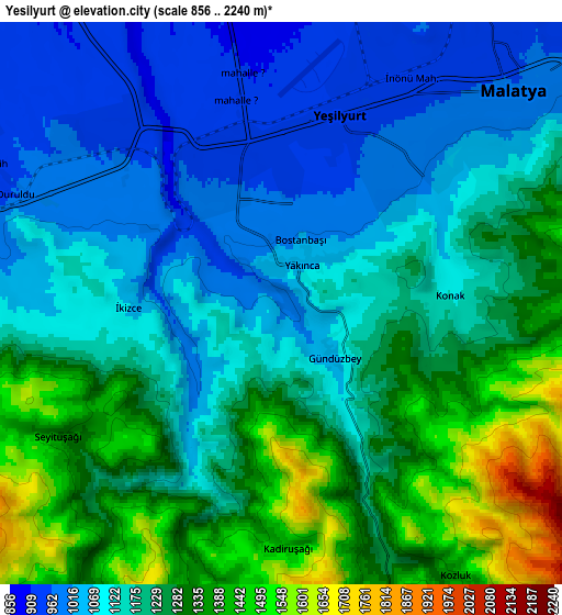
These maps also provides idea of topography and contour of this city, they are displayed at different zoom levels. More info about maps, scale and edge coordinates you can find below images.
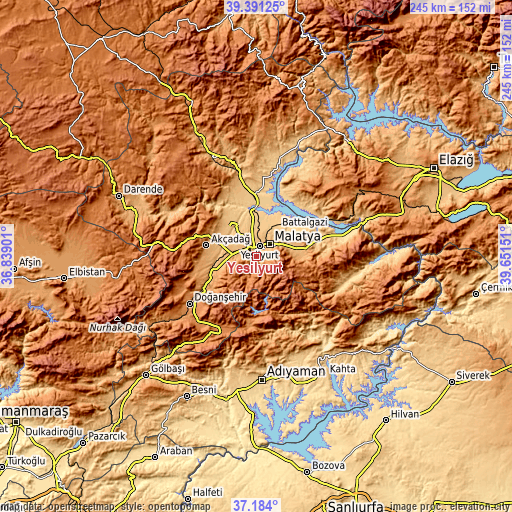
| \ | Map #1 | Map #2 | Topo.Map |
| Scale [m] | 890..1654 m | 856..2240 m | × |
| Scale [ft] | 2920..5427 ft | 2808..7349 ft | × |
| Average | 1091 m = 3579 ft | 1198.1 m = 3931 ft | × |
| Width | 7.67 km = 4.8 mi | 15.34 km = 9.5 mi | 245.4 km = 152.5 mi |
| Height | 7.67 km = 4.8 mi | 15.34 km = 9.5 mi | 245.4 km = 152.5 mi |
| ↑Max Latitude | 38.330501° | 38.364965° | 39.39125° |
| Latitude at center | 38.29602° | 38.29602° | 38.29602° |
| ↓Min Latitude | 38.261523° | 38.227009° | 37.184° |
| ← Min Longitude | 38.201315° | 38.157369° | 36.83901° |
| Longitude center | 38.24526° | 38.24526° | 38.24526° |
| →Max Longitude | 38.289205° | 38.333151° | 39.65151° |
Nearby cities:
Cities around Yeşilyurt sort by population:
• Malatya elevation 963 m
8.7 km,  45°
45°
• Doğanşehir 1248 m
40.2 km,  234°
234°
• Akçadağ 1067 m
24.5 km,  281°
281°
• Çelikhan 1394 m
30.1 km,  181°
181°
• Yazıhan 826 m
33.6 km,  349°
349°
• Kuşsarayı 796 m
41.6 km,  65°
65°
• Koçali 1136 m
41.5 km, 178°
• Sürgü 1318 m
40.6 km,  217°
217°
• Levent 1356 m
37.5 km,  294°
294°
• Yarpuzlu 1030 m
36.1 km,  138°
138°
• Çolaklı 1118 m
24.3 km,  80°
80°
• Battalgazi 784 m
17.2 km,  34°
34°
Multilingual:
 En español:
Yeşilyurt elevación 989 m.
 En France:
Yeşilyurt élévation 989 m.
 Auf Deutsch:
Yeşilyurt höhe über dem Meeresspiegel ist 989 m.

Sources and notes:
- [note 1] Map square and city borders are not equal. Map elevation data is calculated only from area inside that square.
- [src 1] Elevation data from geonames database provided with same terms of usage.
- [src 2] The elevation map of Yeşilyurt is generated using elevation data from NASA's 3 arcsec (90m) resolution SRTM data.
- [src 3] Base (background) map © OpenStreetMap contributors tiles are generated by Geofabrik and OpenTopoMap.
Copyright & License:
This Yeşilyurt Elevation Map is licensed under CC BY-SA. You may reuse any part from this page, if you give a proper credit by linking to this URL:
 More info on terms of use page.