Maktar elevation
Maktar (Silyānah, Mu‘tamadīyat Makthar), Tunisia elevation is 924 meters and Maktar elevation in feet is 3031 ft above sea level [src 1]. Maktar is a populated place (feature code) with elevation that is 775 meters (2543 ft) bigger than average city elevation in Tunisia.
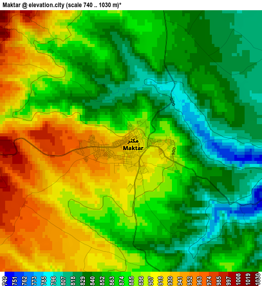
Below is the Elevation map of Maktar, which displays elevation range with different colors. Scale of the first map is from 740 to 1030 m (2428 to 3379 ft) with average elevation of 876.6 meters (=2876 ft) [note 1]
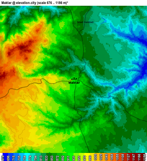
These maps also provides idea of topography and contour of this city, they are displayed at different zoom levels. More info about maps, scale and edge coordinates you can find below images.
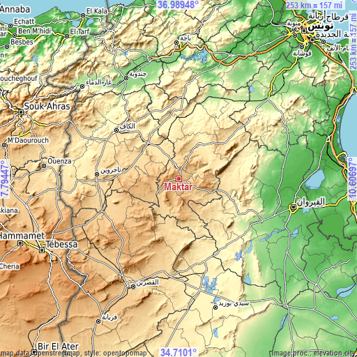
| \ | Map #1 | Map #2 | Topo.Map |
| Scale [m] | 740..1030 m | 676..1186 m | × |
| Scale [ft] | 2428..3379 ft | 2218..3891 ft | × |
| Average | 876.6 m = 2876 ft | 885.6 m = 2906 ft | × |
| Width | 7.92 km = 4.9 mi | 15.84 km = 9.8 mi | 253.4 km = 157.5 mi |
| Height | 7.92 km = 4.9 mi | 15.84 km = 9.8 mi | 253.4 km = 157.5 mi |
| ↑Max Latitude | 35.893588° | 35.929181° | 36.98948° |
| Latitude at center | 35.85798° | 35.85798° | 35.85798° |
| ↓Min Latitude | 35.822356° | 35.786715° | 34.7101° |
| ← Min Longitude | 9.156775° | 9.112829° | 7.79447° |
| Longitude center | 9.20072° | 9.20072° | 9.20072° |
| →Max Longitude | 9.244665° | 9.288611° | 10.60697° |
Nearby cities:
Cities around Maktar sort by population:
• El Kef elevation 627 m
56.8 km,  308°
308°
• Siliana 428 m
29.5 km,  31°
31°
• Tajerouine 660 m
58.5 km,  273°
273°
• Thala 962 m
57.5 km,  236°
236°
• As Sars 487 m
29.2 km,  326°
326°
• Gafour 268 m
52.6 km,  12°
12°
• Haffouz 284 m
49.7 km,  120°
120°
• Le Krib 481 m
52.6 km,  353°
353°
• Sbiba 637 m
36.8 km,  198°
198°
• El Ksour 712 m
28.8 km,  278°
278°
• Rohia 627 m
26.6 km,  210°
210°
• Kesra 999 m
15.6 km,  108°
108°
Multilingual:
 En español:
Maktar elevación 924 m.
 En France:
Maktar élévation 924 m.


Sources and notes:
- [note 1] Map square and city borders are not equal. Map elevation data is calculated only from area inside that square.
- [src 1] Elevation data from geonames database provided with same terms of usage.
- [src 2] The elevation map of Maktar is generated using elevation data from NASA's 3 arcsec (90m) resolution SRTM data.
- [src 3] Base (background) map © OpenStreetMap contributors tiles are generated by Geofabrik and OpenTopoMap.
Copyright & License:
This Maktar Elevation Map is licensed under CC BY-SA. You may reuse any part from this page, if you give a proper credit by linking to this URL:
 More info on terms of use page.