El Kef elevation
El Kef (Kef), Tunisia elevation is 627 meters and El Kef elevation in feet is 2057 ft above sea level [src 1]. El Kef is a seat of a first-order administrative division (feature code) with elevation that is 478 meters (1568 ft) bigger than average city elevation in Tunisia.
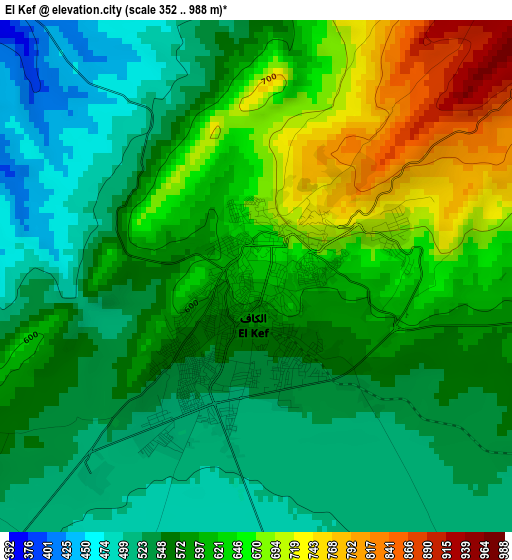
Below is the Elevation map of El Kef, which displays elevation range with different colors. Scale of the first map is from 352 to 988 m (1155 to 3241 ft) with average elevation of 588.8 meters (=1932 ft) [note 1]
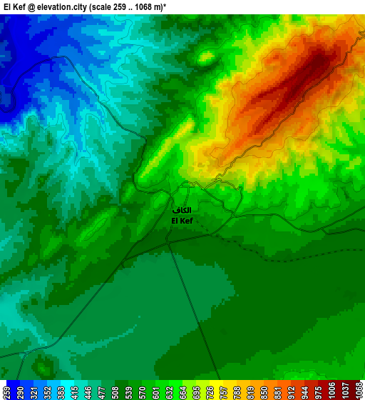
These maps also provides idea of topography and contour of this city, they are displayed at different zoom levels. More info about maps, scale and edge coordinates you can find below images.
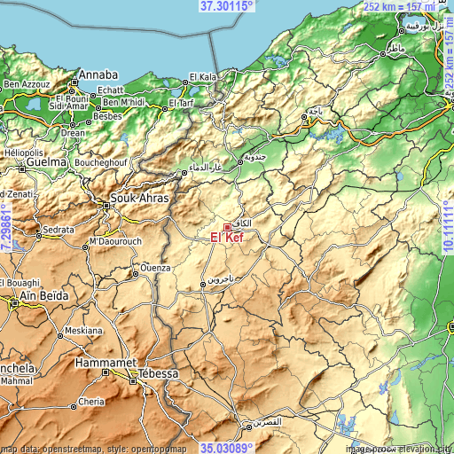
| \ | Map #1 | Map #2 | Topo.Map |
| Scale [m] | 352..988 m | 259..1068 m | × |
| Scale [ft] | 1155..3241 ft | 850..3504 ft | × |
| Average | 588.8 m = 1932 ft | 554.5 m = 1819 ft | × |
| Width | 7.89 km = 4.9 mi | 15.78 km = 9.8 mi | 252.4 km = 156.8 mi |
| Height | 7.89 km = 4.9 mi | 15.78 km = 9.8 mi | 252.4 km = 156.8 mi |
| ↑Max Latitude | 36.209706° | 36.245155° | 37.30115° |
| Latitude at center | 36.17424° | 36.17424° | 36.17424° |
| ↓Min Latitude | 36.138758° | 36.10326° | 35.03089° |
| ← Min Longitude | 8.660915° | 8.616969° | 7.29861° |
| Longitude center | 8.70486° | 8.70486° | 8.70486° |
| →Max Longitude | 8.748805° | 8.792751° | 10.11111° |
Nearby cities:
Cities around El Kef sort by population:
• Jendouba elevation 143 m
37 km,  10°
10°
• Tajerouine 660 m
34.3 km,  203°
203°
• Maktar 924 m
56.8 km,  128°
128°
• Tabursuq 426 m
57.9 km,  57°
57°
• As Sars 487 m
30.4 km,  110°
110°
• Le Krib 481 m
42.3 km,  66°
66°
• Sakiet Sidi Youssef 808 m
31.8 km,  279°
279°
• El Ksour 712 m
34.9 km,  152°
152°
• Nibbar 405 m
14.4 km,  22°
22°
• Menzel Salem 624 m
40.8 km,  210°
210°
• Oued Meliz 175 m
35.5 km,  336°
336°
• Fernana 291 m
53.5 km,  359°
359°
Multilingual:
 En español:
El Kef elevación 627 m.
 En France:
El Kef élévation 627 m.


Sources and notes:
- [note 1] Map square and city borders are not equal. Map elevation data is calculated only from area inside that square.
- [src 1] Elevation data from geonames database provided with same terms of usage.
- [src 2] The elevation map of El Kef is generated using elevation data from NASA's 3 arcsec (90m) resolution SRTM data.
- [src 3] Base (background) map © OpenStreetMap contributors tiles are generated by Geofabrik and OpenTopoMap.
Copyright & License:
This El Kef Elevation Map is licensed under CC BY-SA. You may reuse any part from this page, if you give a proper credit by linking to this URL:
 More info on terms of use page.