Jendouba elevation
Jendouba (Jundūbah), Tunisia elevation is 143 meters and Jendouba elevation in feet is 469 ft above sea level [src 1]. Jendouba is a seat of a first-order administrative division (feature code) with elevation that is 6 meters (20 ft) smaller than average city elevation in Tunisia.
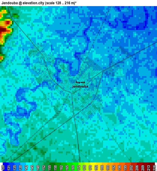
Below is the Elevation map of Jendouba, which displays elevation range with different colors. Scale of the first map is from 128 to 216 m (420 to 709 ft) with average elevation of 142.7 meters (=468 ft) [note 1]
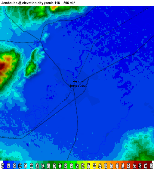
These maps also provides idea of topography and contour of this city, they are displayed at different zoom levels. More info about maps, scale and edge coordinates you can find below images.
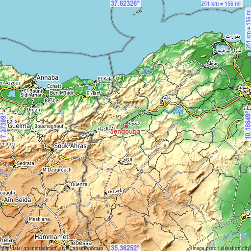
| \ | Map #1 | Map #2 | Topo.Map |
| Scale [m] | 128..216 m | 118..596 m | × |
| Scale [ft] | 420..709 ft | 387..1955 ft | × |
| Average | 142.7 m = 468 ft | 162.6 m = 533 ft | × |
| Width | 7.86 km = 4.9 mi | 15.71 km = 9.8 mi | 251.4 km = 156.2 mi |
| Height | 7.86 km = 4.9 mi | 15.71 km = 9.8 mi | 251.4 km = 156.2 mi |
| ↑Max Latitude | 36.536457° | 36.571758° | 37.62326° |
| Latitude at center | 36.50114° | 36.50114° | 36.50114° |
| ↓Min Latitude | 36.465807° | 36.430457° | 35.36252° |
| ← Min Longitude | 8.736295° | 8.692349° | 7.37399° |
| Longitude center | 8.78024° | 8.78024° | 8.78024° |
| →Max Longitude | 8.824185° | 8.868131° | 10.18649° |
Nearby cities:
Cities around Jendouba sort by population:
• Béja elevation 248 m
43.7 km,  55°
55°
• El Kef 627 m
37 km,  190°
190°
• Tabarka 2 m
50.4 km,  357°
357°
• Testour 93 m
59.5 km,  84°
84°
• Tabursuq 426 m
42.1 km,  96°
96°
• As Sars 487 m
51.9 km,  155°
155°
• Gafour 268 m
52.7 km,  112°
112°
• Le Krib 481 m
37.2 km,  121°
121°
• Sakiet Sidi Youssef 808 m
49 km,  230°
230°
• Nibbar 405 m
23.1 km,  183°
183°
• Oued Meliz 175 m
21 km,  259°
259°
• Fernana 291 m
18.7 km,  336°
336°
Multilingual:
 En español:
Jendouba elevación 143 m.
 En France:
Jendouba élévation 143 m.
 Auf Deutsch:
Jendouba höhe über dem Meeresspiegel ist 143 m.

Sources and notes:
- [note 1] Map square and city borders are not equal. Map elevation data is calculated only from area inside that square.
- [src 1] Elevation data from geonames database provided with same terms of usage.
- [src 2] The elevation map of Jendouba is generated using elevation data from NASA's 3 arcsec (90m) resolution SRTM data.
- [src 3] Base (background) map © OpenStreetMap contributors tiles are generated by Geofabrik and OpenTopoMap.
Copyright & License:
This Jendouba Elevation Map is licensed under CC BY-SA. You may reuse any part from this page, if you give a proper credit by linking to this URL:
 More info on terms of use page.