Gafour elevation
Gafour (Silyānah, Gaafour), Tunisia elevation is 268 meters and Gafour elevation in feet is 879 ft above sea level [src 1]. Gafour is a populated place (feature code) with elevation that is 119 meters (390 ft) bigger than average city elevation in Tunisia.
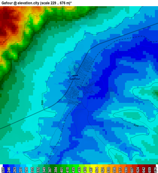
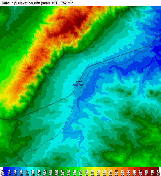
Below is the Elevation map of Gafour, which displays elevation range with different colors. Scale of the first map is from 229 to 676 m (751 to 2218 ft) with average elevation of 315 meters (=1033 ft) [note 1]
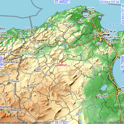
These maps also provides idea of topography and contour of this city, they are displayed at different zoom levels. More info about maps, scale and edge coordinates you can find below images.
| \ | Map #1 | Map #2 | Topo.Map |
| Scale [m] | 229..676 m | 191..752 m | × |
| Scale [ft] | 751..2218 ft | 627..2467 ft | × |
| Average | 315 m = 1033 ft | 368.9 m = 1210 ft | × |
| Width | 7.87 km = 4.9 mi | 15.75 km = 9.8 mi | 252 km = 156.6 mi |
| Height | 7.87 km = 4.9 mi | 15.75 km = 9.8 mi | 252 km = 156.6 mi |
| ↑Max Latitude | 36.355849° | 36.391233° | 37.44522° |
| Latitude at center | 36.32045° | 36.32045° | 36.32045° |
| ↓Min Latitude | 36.285034° | 36.249603° | 35.17921° |
| ← Min Longitude | 9.280295° | 9.236349° | 7.91799° |
| Longitude center | 9.32424° | 9.32424° | 9.32424° |
| →Max Longitude | 9.368185° | 9.412131° | 10.73049° |
Nearby cities:
Cities around Gafour sort by population:
• Béja elevation 248 m
46.8 km,  344°
344°
• Siliana 428 m
26.5 km,  170°
170°
• Medjez el Bab 51 m
44.8 km,  35°
35°
• El Fahs 195 m
52.5 km,  83°
83°
• Maktar 924 m
52.6 km,  192°
192°
• Testour 93 m
27.8 km,  22°
22°
• Tabursuq 426 m
16.7 km, 335°
• Bou Arada 246 m
26.9 km, 82°
• As Sars 487 m
38.4 km,  225°
225°
• Le Krib 481 m
16.9 km,  272°
272°
• Nibbar 405 m
50.1 km, 266°
• Goubellat 138 m
39.1 km,  50°
50°
Multilingual:
 En español:
Gafour elevación 268 m.
 En France:
Gafour élévation 268 m.


Sources and notes:
- [note 1] Map square and city borders are not equal. Map elevation data is calculated only from area inside that square.
- [src 1] Elevation data from geonames database provided with same terms of usage.
- [src 2] The elevation map of Gafour is generated using elevation data from NASA's 3 arcsec (90m) resolution SRTM data.
- [src 3] Base (background) map © OpenStreetMap contributors tiles are generated by Geofabrik and OpenTopoMap.
Copyright & License:
This Gafour Elevation Map is licensed under CC BY-SA. You may reuse any part from this page, if you give a proper credit by linking to this URL:
 More info on terms of use page.