Siliana elevation
Siliana (Silyānah, Siliana Nord), Tunisia elevation is 428 meters and Siliana elevation in feet is 1404 ft above sea level [src 1]. Siliana is a seat of a first-order administrative division (feature code) with elevation that is 279 meters (915 ft) bigger than average city elevation in Tunisia.
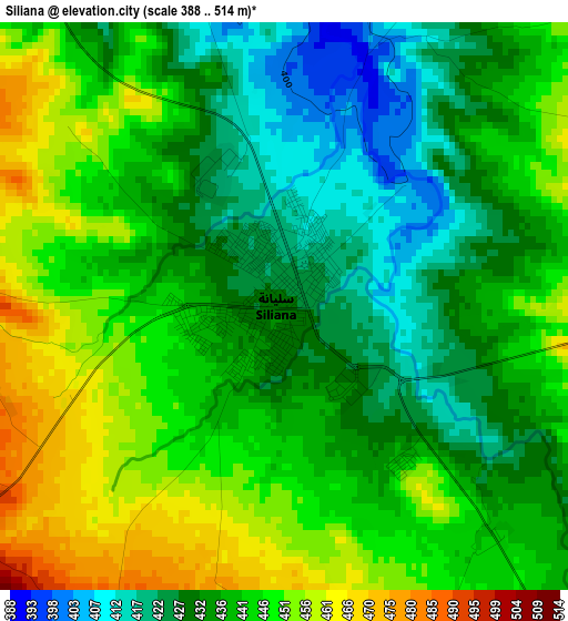
Below is the Elevation map of Siliana, which displays elevation range with different colors. Scale of the first map is from 388 to 514 m (1273 to 1686 ft) with average elevation of 439.2 meters (=1441 ft) [note 1]
These maps also provides idea of topography and contour of this city, they are displayed at different zoom levels. More info about maps, scale and edge coordinates you can find below images.
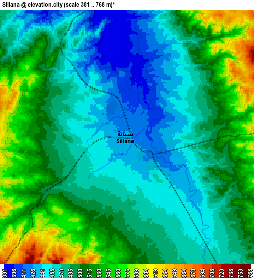
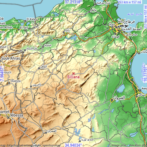
| \ | Map #1 | Map #2 | Topo.Map |
| Scale [m] | 388..514 m | 381..768 m | × |
| Scale [ft] | 1273..1686 ft | 1250..2520 ft | × |
| Average | 439.2 m = 1441 ft | 492.3 m = 1615 ft | × |
| Width | 7.9 km = 4.9 mi | 15.8 km = 9.8 mi | 252.7 km = 157 mi |
| Height | 7.9 km = 4.9 mi | 15.8 km = 9.8 mi | 252.7 km = 157 mi |
| ↑Max Latitude | 36.120476° | 36.155966° | 37.21318° |
| Latitude at center | 36.08497° | 36.08497° | 36.08497° |
| ↓Min Latitude | 36.049448° | 36.01391° | 34.94034° |
| ← Min Longitude | 9.326875° | 9.282929° | 7.96457° |
| Longitude center | 9.37082° | 9.37082° | 9.37082° |
| →Max Longitude | 9.414765° | 9.458711° | 10.77707° |
Nearby cities:
Cities around Siliana sort by population:
• Maktar elevation 924 m
29.5 km,  211°
211°
• Testour 93 m
52.3 km,  7°
7°
• Tabursuq 426 m
42.8 km,  345°
345°
• Bou Arada 246 m
37.3 km,  37°
37°
• As Sars 487 m
31.4 km,  268°
268°
• Gafour 268 m
26.5 km, 350°
• Haffouz 284 m
57.4 km,  151°
151°
• Le Krib 481 m
34.3 km,  322°
322°
• El Ksour 712 m
48.5 km,  244°
244°
• Rohia 627 m
56.1 km, 210°
• Goubellat 138 m
57.2 km,  27°
27°
• Kesra 999 m
30.2 km,  181°
181°
Multilingual:
 En español:
Siliana elevación 428 m.
 En France:
Siliana élévation 428 m.


Sources and notes:
- [note 1] Map square and city borders are not equal. Map elevation data is calculated only from area inside that square.
- [src 1] Elevation data from geonames database provided with same terms of usage.
- [src 2] The elevation map of Siliana is generated using elevation data from NASA's 3 arcsec (90m) resolution SRTM data.
- [src 3] Base (background) map © OpenStreetMap contributors tiles are generated by Geofabrik and OpenTopoMap.
Copyright & License:
This Siliana Elevation Map is licensed under CC BY-SA. You may reuse any part from this page, if you give a proper credit by linking to this URL:
 More info on terms of use page.