Thala elevation
Thala (Al Qaşrayn), Tunisia elevation is 962 meters and Thala elevation in feet is 3156 ft above sea level [src 1]. Thala is a populated place (feature code) with elevation that is 813 meters (2667 ft) bigger than average city elevation in Tunisia.
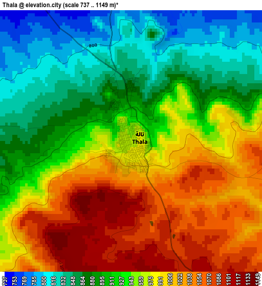
Below is the Elevation map of Thala, which displays elevation range with different colors. Scale of the first map is from 737 to 1149 m (2418 to 3770 ft) with average elevation of 945.4 meters (=3102 ft) [note 1]
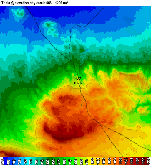
These maps also provides idea of topography and contour of this city, they are displayed at different zoom levels. More info about maps, scale and edge coordinates you can find below images.
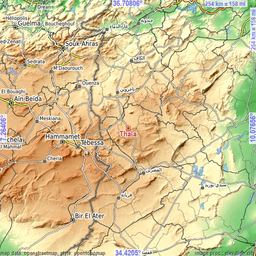
| \ | Map #1 | Map #2 | Topo.Map |
| Scale [m] | 737..1149 m | 666..1209 m | × |
| Scale [ft] | 2418..3770 ft | 2185..3967 ft | × |
| Average | 945.4 m = 3102 ft | 895.9 m = 2939 ft | × |
| Width | 7.95 km = 4.9 mi | 15.9 km = 9.9 mi | 254.4 km = 158.1 mi |
| Height | 7.95 km = 4.9 mi | 15.9 km = 9.9 mi | 254.4 km = 158.1 mi |
| ↑Max Latitude | 35.608176° | 35.643897° | 36.70806° |
| Latitude at center | 35.57244° | 35.57244° | 35.57244° |
| ↓Min Latitude | 35.536688° | 35.50092° | 34.4205° |
| ← Min Longitude | 8.626365° | 8.582419° | 7.26406° |
| Longitude center | 8.67031° | 8.67031° | 8.67031° |
| →Max Longitude | 8.714255° | 8.758201° | 10.07656° |
Nearby cities:
Cities around Thala sort by population:
• Kasserine elevation 674 m
47.5 km,  161°
161°
• El Kef 627 m
67 km,  2°
2°
• Tajerouine 660 m
37.1 km,  343°
343°
• Maktar 924 m
57.5 km,  56°
56°
• As Sars 487 m
64.3 km,  29°
29°
• Sakiet Sidi Youssef 808 m
77.7 km, 338°
• Sbiba 637 m
36.6 km,  95°
95°
• Jilma 364 m
76 km,  115°
115°
• El Ksour 712 m
40.9 km, 28°
• Rohia 627 m
35.7 km,  75°
75°
• Menzel Salem 624 m
36.1 km,  331°
331°
• Kesra 999 m
68.2 km,  66°
66°
Multilingual:
 En español:
Thala elevación 962 m.
 En France:
Thala élévation 962 m.


Sources and notes:
- [note 1] Map square and city borders are not equal. Map elevation data is calculated only from area inside that square.
- [src 1] Elevation data from geonames database provided with same terms of usage.
- [src 2] The elevation map of Thala is generated using elevation data from NASA's 3 arcsec (90m) resolution SRTM data.
- [src 3] Base (background) map © OpenStreetMap contributors tiles are generated by Geofabrik and OpenTopoMap.
Copyright & License:
This Thala Elevation Map is licensed under CC BY-SA. You may reuse any part from this page, if you give a proper credit by linking to this URL:
 More info on terms of use page.