Roghun elevation
Roghun (Republican Subordination), Tajikistan elevation is 1251 meters and Roghun elevation in feet is 4104 ft above sea level [src 1]. Roghun is a populated place (feature code) with elevation that is 297 meters (974 ft) bigger than average city elevation in Tajikistan.
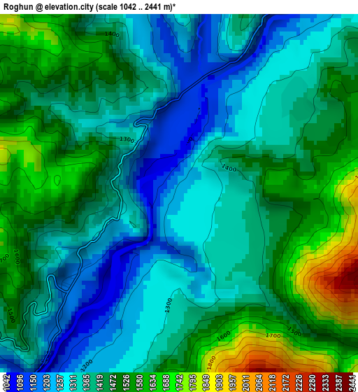
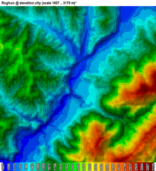
Below is the Elevation map of Roghun, which displays elevation range with different colors. Scale of the first map is from 1042 to 2441 m (3419 to 8009 ft) with average elevation of 1419 meters (=4656 ft) [note 1]
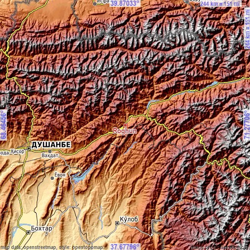
These maps also provides idea of topography and contour of this city, they are displayed at different zoom levels. More info about maps, scale and edge coordinates you can find below images.
| \ | Map #1 | Map #2 | Topo.Map |
| Scale [m] | 1042..2441 m | 1007..3170 m | × |
| Scale [ft] | 3419..8009 ft | 3304..10400 ft | × |
| Average | 1419 m = 4656 ft | 1673.1 m = 5489 ft | × |
| Width | 7.62 km = 4.7 mi | 15.24 km = 9.5 mi | 243.8 km = 151.5 mi |
| Height | 7.62 km = 4.7 mi | 15.24 km = 9.5 mi | 243.8 km = 151.5 mi |
| ↑Max Latitude | 38.816818° | 38.85105° | 39.87033° |
| Latitude at center | 38.78257° | 38.78257° | 38.78257° |
| ↓Min Latitude | 38.748305° | 38.714024° | 37.67796° |
| ← Min Longitude | 69.826865° | 69.782919° | 68.46456° |
| Longitude center | 69.87081° | 69.87081° | 69.87081° |
| →Max Longitude | 69.914755° | 69.958701° | 71.27706° |
Nearby cities:
Cities around Roghun sort by population:
• Vahdat elevation 872 m
78.6 km,  251°
251°
• Norak 660 m
64.7 km,  227°
227°
• Mŭ’minobod 1247 m
76.4 km,  169°
169°
• Rasht 1371 m
51.5 km,  57°
57°
• Obigarm 1358 m
15.8 km,  242°
242°
• Novobod 1276 m
35.1 km,  43°
43°
• Darband 1254 m
12.6 km, 41°
• Baljuvon 915 m
55.4 km,  197°
197°
• Fayzobod 1212 m
54.5 km, 241°
• Tavildara 1618 m
54.1 km,  100°
100°
• Khovaling 1416 m
49.8 km, 169°
• Roghun 1454 m
15.3 km, 229°
Multilingual:
 En español:
Roghun elevación 1251 m.
 En France:
Roghun élévation 1251 m.


Sources and notes:
- [note 1] Map square and city borders are not equal. Map elevation data is calculated only from area inside that square.
- [src 1] Elevation data from geonames database provided with same terms of usage.
- [src 2] The elevation map of Roghun is generated using elevation data from NASA's 3 arcsec (90m) resolution SRTM data.
- [src 3] Base (background) map © OpenStreetMap contributors tiles are generated by Geofabrik and OpenTopoMap.
Copyright & License:
This Roghun Elevation Map is licensed under CC BY-SA. You may reuse any part from this page, if you give a proper credit by linking to this URL:
 More info on terms of use page.