Rasht elevation
Rasht (Republican Subordination), Tajikistan elevation is 1371 meters and Rasht elevation in feet is 4498 ft above sea level [src 1]. Rasht is a seat of a second-order administrative division (feature code) with elevation that is 417 meters (1368 ft) bigger than average city elevation in Tajikistan.
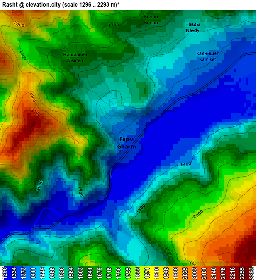
Below is the Elevation map of Rasht, which displays elevation range with different colors. Scale of the first map is from 1296 to 2293 m (4252 to 7523 ft) with average elevation of 1606.7 meters (=5271 ft) [note 1]
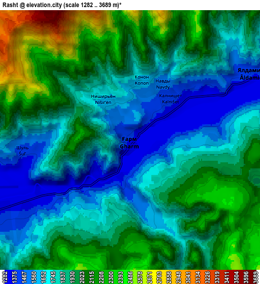
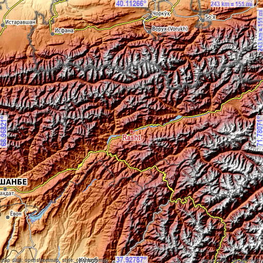
These maps also provides idea of topography and contour of this city, they are displayed at different zoom levels. More info about maps, scale and edge coordinates you can find below images.
| \ | Map #1 | Map #2 | Topo.Map |
| Scale [m] | 1296..2293 m | 1282..3689 m | × |
| Scale [ft] | 4252..7523 ft | 4206..12103 ft | × |
| Average | 1606.7 m = 5271 ft | 1911.9 m = 6273 ft | × |
| Width | 7.59 km = 4.7 mi | 15.18 km = 9.4 mi | 242.9 km = 150.9 mi |
| Height | 7.59 km = 4.7 mi | 15.18 km = 9.4 mi | 242.9 km = 150.9 mi |
| ↑Max Latitude | 39.06284° | 39.096953° | 40.11266° |
| Latitude at center | 39.02871° | 39.02871° | 39.02871° |
| ↓Min Latitude | 38.994564° | 38.960401° | 37.92787° |
| ← Min Longitude | 70.330515° | 70.286569° | 68.96821° |
| Longitude center | 70.37446° | 70.37446° | 70.37446° |
| →Max Longitude | 70.418405° | 70.462351° | 71.78071° |
Nearby cities:
Cities around Rasht sort by population:
• Obigarm elevation 1358 m
67.2 km,  238°
238°
• Roghun 1251 m
51.5 km, 237°
• Novobod 1276 m
19.4 km,  264°
264°
• Vorukh 1400 m
93.1 km,  10°
10°
• Darband 1254 m
39.6 km, 243°
• Baljuvon 915 m
100.4 km,  217°
217°
• Khovaling 1416 m
83.9 km,  204°
204°
• Jirghatol 1837 m
73.6 km,  73°
73°
• Qalaikhumb 1258 m
73.3 km,  150°
150°
• Roghun 1454 m
66.6 km, 235°
• Tajikobod 1542 m
41.6 km,  75°
75°
• Tavildara 1618 m
38.3 km,  165°
165°
Multilingual:
 En español:
Rasht elevación 1371 m.
 En France:
Rasht élévation 1371 m.


Sources and notes:
- [note 1] Map square and city borders are not equal. Map elevation data is calculated only from area inside that square.
- [src 1] Elevation data from geonames database provided with same terms of usage.
- [src 2] The elevation map of Rasht is generated using elevation data from NASA's 3 arcsec (90m) resolution SRTM data.
- [src 3] Base (background) map © OpenStreetMap contributors tiles are generated by Geofabrik and OpenTopoMap.
Copyright & License:
This Rasht Elevation Map is licensed under CC BY-SA. You may reuse any part from this page, if you give a proper credit by linking to this URL:
 More info on terms of use page.