Novobod elevation
Novobod (Republican Subordination), Tajikistan elevation is 1276 meters and Novobod elevation in feet is 4186 ft above sea level [src 1]. Novobod is a populated place (feature code) with elevation that is 322 meters (1056 ft) bigger than average city elevation in Tajikistan.
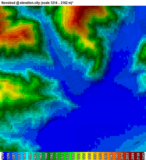
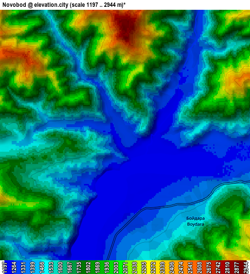
Below is the Elevation map of Novobod, which displays elevation range with different colors. Scale of the first map is from 1214 to 2162 m (3983 to 7093 ft) with average elevation of 1406.9 meters (=4616 ft) [note 1]
These maps also provides idea of topography and contour of this city, they are displayed at different zoom levels. More info about maps, scale and edge coordinates you can find below images.
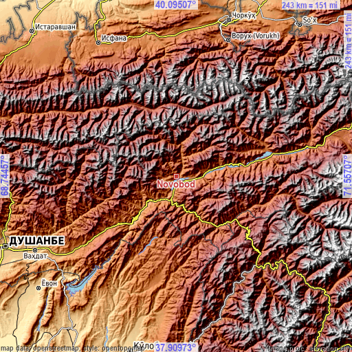
| \ | Map #1 | Map #2 | Topo.Map |
| Scale [m] | 1214..2162 m | 1197..2944 m | × |
| Scale [ft] | 3983..7093 ft | 3927..9659 ft | × |
| Average | 1406.9 m = 4616 ft | 1630 m = 5348 ft | × |
| Width | 7.59 km = 4.7 mi | 15.19 km = 9.4 mi | 243 km = 151 mi |
| Height | 7.59 km = 4.7 mi | 15.19 km = 9.4 mi | 243 km = 151 mi |
| ↑Max Latitude | 39.044978° | 39.0791° | 40.09507° |
| Latitude at center | 39.01084° | 39.01084° | 39.01084° |
| ↓Min Latitude | 38.976685° | 38.942514° | 37.90973° |
| ← Min Longitude | 70.106875° | 70.062929° | 68.74457° |
| Longitude center | 70.15082° | 70.15082° | 70.15082° |
| →Max Longitude | 70.194765° | 70.238711° | 71.55707° |
Nearby cities:
Cities around Novobod sort by population:
• Rasht elevation 1371 m
19.4 km,  84°
84°
• Obigarm 1358 m
50.3 km,  229°
229°
• Roghun 1251 m
35.1 km,  223°
223°
• Darband 1254 m
22.5 km, 225°
• Fayzobod 1212 m
88.6 km, 234°
• Baljuvon 915 m
88.3 km,  207°
207°
• Mehron 2043 m
87.1 km,  301°
301°
• Qalaikhumb 1258 m
83.1 km,  138°
138°
• Khovaling 1416 m
75.9 km,  191°
191°
• Tajikobod 1542 m
60.8 km, 78°
• Roghun 1454 m
50.3 km, 225°
• Tavildara 1618 m
45.4 km, 140°
Multilingual:
 En español:
Novobod elevación 1276 m.
 En France:
Novobod élévation 1276 m.
 Auf Deutsch:
Novobod höhe über dem Meeresspiegel ist 1276 m.

Sources and notes:
- [note 1] Map square and city borders are not equal. Map elevation data is calculated only from area inside that square.
- [src 1] Elevation data from geonames database provided with same terms of usage.
- [src 2] The elevation map of Novobod is generated using elevation data from NASA's 3 arcsec (90m) resolution SRTM data.
- [src 3] Base (background) map © OpenStreetMap contributors tiles are generated by Geofabrik and OpenTopoMap.
Copyright & License:
This Novobod Elevation Map is licensed under CC BY-SA. You may reuse any part from this page, if you give a proper credit by linking to this URL:
 More info on terms of use page.