Vahdat elevation
Vahdat (Republican Subordination), Tajikistan elevation is 872 meters and Vahdat elevation in feet is 2861 ft above sea level [src 1]. Vahdat is a seat of a second-order administrative division (feature code) with elevation that is 82 meters (269 ft) smaller than average city elevation in Tajikistan.
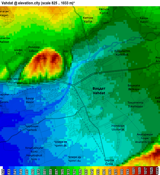
Below is the Elevation map of Vahdat, which displays elevation range with different colors. Scale of the first map is from 825 to 1033 m (2707 to 3389 ft) with average elevation of 885.8 meters (=2906 ft) [note 1]
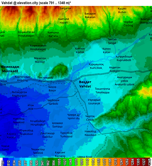
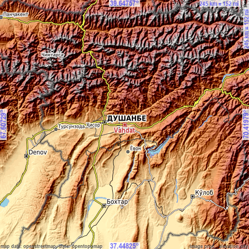
These maps also provides idea of topography and contour of this city, they are displayed at different zoom levels. More info about maps, scale and edge coordinates you can find below images.
| \ | Map #1 | Map #2 | Topo.Map |
| Scale [m] | 825..1033 m | 791..1348 m | × |
| Scale [ft] | 2707..3389 ft | 2595..4423 ft | × |
| Average | 885.8 m = 2906 ft | 936.7 m = 3073 ft | × |
| Width | 7.64 km = 4.7 mi | 15.28 km = 9.5 mi | 244.5 km = 151.9 mi |
| Height | 7.64 km = 4.7 mi | 15.28 km = 9.5 mi | 244.5 km = 151.9 mi |
| ↑Max Latitude | 38.590677° | 38.625017° | 39.64757° |
| Latitude at center | 38.55632° | 38.55632° | 38.55632° |
| ↓Min Latitude | 38.521947° | 38.487557° | 37.44825° |
| ← Min Longitude | 68.969595° | 68.925649° | 67.60729° |
| Longitude center | 69.01354° | 69.01354° | 69.01354° |
| →Max Longitude | 69.057485° | 69.101431° | 70.41979° |
Nearby cities:
Cities around Vahdat sort by population:
• Dushanbe elevation 767 m
20.5 km,  263°
263°
• Hisor 800 m
40.4 km,  265°
265°
• Boshkengash 755 m
20.7 km,  241°
241°
• Danghara 652 m
58.6 km,  150°
150°
• Norak 660 m
32.7 km,  124°
124°
• Yovon 654 m
27 km,  175°
175°
• Khodzha-Maston 1565 m
39.6 km,  301°
301°
• Tagob 1467 m
32.9 km,  342°
342°
• Varzob 1107 m
29.5 km,  324°
324°
• Obikiik 662 m
53.4 km,  214°
214°
• Fayzobod 1212 m
26.6 km,  92°
92°
• Somoniyon 742 m
24.4 km, 238°
Multilingual:
 En español:
Vahdat elevación 872 m.
 En France:
Vahdat élévation 872 m.


Sources and notes:
- [note 1] Map square and city borders are not equal. Map elevation data is calculated only from area inside that square.
- [src 1] Elevation data from geonames database provided with same terms of usage.
- [src 2] The elevation map of Vahdat is generated using elevation data from NASA's 3 arcsec (90m) resolution SRTM data.
- [src 3] Base (background) map © OpenStreetMap contributors tiles are generated by Geofabrik and OpenTopoMap.
Copyright & License:
This Vahdat Elevation Map is licensed under CC BY-SA. You may reuse any part from this page, if you give a proper credit by linking to this URL:
 More info on terms of use page.