Boshkengash elevation
Boshkengash (Dushanbe), Tajikistan elevation is 755 meters and Boshkengash elevation in feet is 2477 ft above sea level [src 1]. Boshkengash is a populated place (feature code) with elevation that is 199 meters (653 ft) smaller than average city elevation in Tajikistan.
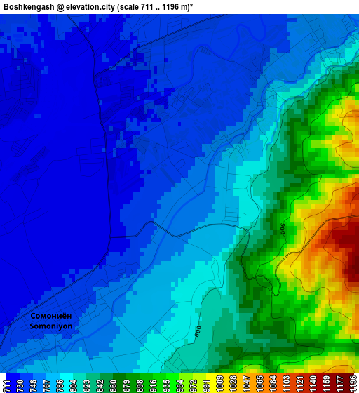
Below is the Elevation map of Boshkengash, which displays elevation range with different colors. Scale of the first map is from 711 to 1196 m (2333 to 3924 ft) with average elevation of 795.4 meters (=2610 ft) [note 1]
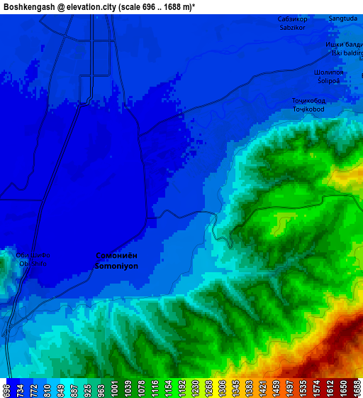
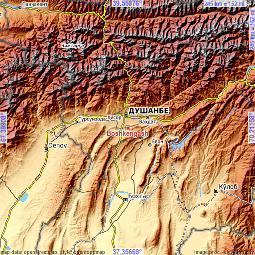
These maps also provides idea of topography and contour of this city, they are displayed at different zoom levels. More info about maps, scale and edge coordinates you can find below images.
| \ | Map #1 | Map #2 | Topo.Map |
| Scale [m] | 711..1196 m | 696..1688 m | × |
| Scale [ft] | 2333..3924 ft | 2283..5538 ft | × |
| Average | 795.4 m = 2610 ft | 874.4 m = 2869 ft | × |
| Width | 7.65 km = 4.8 mi | 15.3 km = 9.5 mi | 244.8 km = 152.1 mi |
| Height | 7.65 km = 4.8 mi | 15.3 km = 9.5 mi | 244.8 km = 152.1 mi |
| ↑Max Latitude | 38.50053° | 38.534913° | 39.55876° |
| Latitude at center | 38.46613° | 38.46613° | 38.46613° |
| ↓Min Latitude | 38.431714° | 38.397281° | 37.35669° |
| ← Min Longitude | 68.761385° | 68.717439° | 67.39908° |
| Longitude center | 68.80533° | 68.80533° | 68.80533° |
| →Max Longitude | 68.849275° | 68.893221° | 70.21158° |
Nearby cities:
Cities around Boshkengash sort by population:
• Dushanbe elevation 767 m
8.1 km,  343°
343°
• Vahdat 872 m
20.7 km,  61°
61°
• Hisor 800 m
23.1 km,  286°
286°
• Norak 660 m
45.9 km,  100°
100°
• Yovon 654 m
26.4 km,  129°
129°
• Khodzha-Maston 1565 m
34.6 km,  333°
333°
• Shahrinav 850 m
42.5 km, 285°
• Tagob 1467 m
42.2 km,  11°
11°
• Varzob 1107 m
34.2 km,  1°
1°
• Fayzobod 1212 m
45.7 km,  78°
78°
• Obikiik 662 m
36.1 km,  199°
199°
• Somoniyon 742 m
3.8 km,  224°
224°
Multilingual:
 En español:
Boshkengash elevación 755 m.
 En France:
Boshkengash élévation 755 m.
 Auf Deutsch:
Boshkengash höhe über dem Meeresspiegel ist 755 m.

Sources and notes:
- [note 1] Map square and city borders are not equal. Map elevation data is calculated only from area inside that square.
- [src 1] Elevation data from geonames database provided with same terms of usage.
- [src 2] The elevation map of Boshkengash is generated using elevation data from NASA's 3 arcsec (90m) resolution SRTM data.
- [src 3] Base (background) map © OpenStreetMap contributors tiles are generated by Geofabrik and OpenTopoMap.
Copyright & License:
This Boshkengash Elevation Map is licensed under CC BY-SA. You may reuse any part from this page, if you give a proper credit by linking to this URL:
 More info on terms of use page.