As Sukhnah elevation
As Sukhnah (Homs), Syria elevation is 477 meters and As Sukhnah elevation in feet is 1565 ft above sea level [src 1]. As Sukhnah is a seat of a third-order administrative division (feature code) with elevation that is 52 meters (171 ft) smaller than average city elevation in Syria.
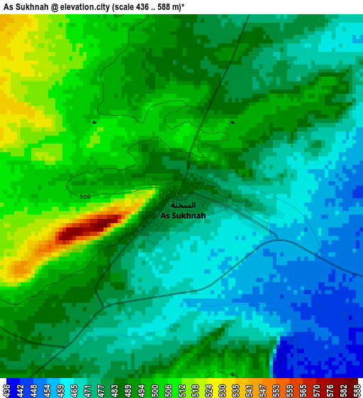
Below is the Elevation map of As Sukhnah, which displays elevation range with different colors. Scale of the first map is from 436 to 588 m (1430 to 1929 ft) with average elevation of 484.2 meters (=1589 ft) [note 1]
These maps also provides idea of topography and contour of this city, they are displayed at different zoom levels. More info about maps, scale and edge coordinates you can find below images.
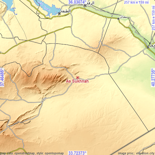
| \ | Map #1 | Topo.Map |
| Scale [m] | 436..588 m | × |
| Scale [ft] | 1430..1929 ft | × |
| Average | 484.2 m = 1589 ft | × |
| Width | 8.02 km = 5 mi | 256.5 km = 159.4 mi |
| Height | 8.02 km = 5 mi | 256.5 km = 159.4 mi |
| ↑Max Latitude | 34.92137° | 36.03074° |
| Latitude at center | 34.88533° | 34.88533° |
| ↓Min Latitude | 34.849274° | 33.72373° |
| ← Min Longitude | 38.827155° | 37.46485° |
| Longitude center | 38.8711° | 38.8711° |
| →Max Longitude | 38.915045° | 40.27735° |
Nearby cities:
Cities around As Sukhnah sort by population:
• Deir ez-Zor elevation 210 m
125.9 km,  66°
66°
• Ar Raqqah 259 m
119.3 km,  5°
5°
• Ath Thawrah 342 m
109.9 km,  344°
344°
• Tadmur 418 m
64.6 km,  236°
236°
• Khushām 204 m
137 km, 70°
• ‘Uqayribāt 683 m
129.4 km,  277°
277°
• Al Kasrah 246 m
121.8 km,  51°
51°
• At Tibnī 227 m
118 km, 46°
• Ma‘dān 226 m
117.1 km,  34°
34°
• Al Karāmah 244 m
115.4 km,  18°
18°
• As Sabkhah 251 m
109 km, 19°
• Al Manşūrah 269 m
106.7 km,  353°
353°
Multilingual:
 En español:
As Sukhnah elevación 477 m.
 En France:
As Sukhnah élévation 477 m.
 Auf Deutsch:
As Sukhnah höhe über dem Meeresspiegel ist 477 m.

Sources and notes:
- [note 1] Map square and city borders are not equal. Map elevation data is calculated only from area inside that square.
- [src 1] Elevation data from geonames database provided with same terms of usage.
- [src 2] The elevation map of As Sukhnah is generated using elevation data from NASA's 3 arcsec (90m) resolution SRTM data.
- [src 3] Base (background) map © OpenStreetMap contributors tiles are generated by Geofabrik and OpenTopoMap.
Copyright & License:
This As Sukhnah Elevation Map is licensed under CC BY-SA. You may reuse any part from this page, if you give a proper credit by linking to this URL:
 More info on terms of use page.