Deir ez-Zor elevation
Deir ez-Zor, Syria elevation is 210 meters and Deir ez-Zor elevation in feet is 689 ft above sea level [src 1]. Deir ez-Zor is a seat of a first-order administrative division (feature code) with elevation that is 319 meters (1047 ft) smaller than average city elevation in Syria.
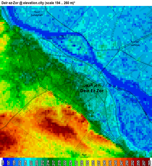
Below is the Elevation map of Deir ez-Zor, which displays elevation range with different colors. Scale of the first map is from 194 to 260 m (636 to 853 ft) with average elevation of 215.6 meters (=707 ft) [note 1]
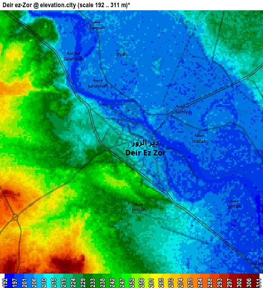
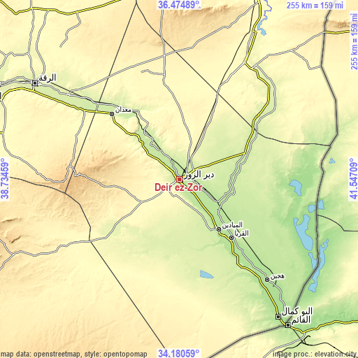
These maps also provides idea of topography and contour of this city, they are displayed at different zoom levels. More info about maps, scale and edge coordinates you can find below images.
| \ | Map #1 | Map #2 | Topo.Map |
| Scale [m] | 194..260 m | 192..311 m | × |
| Scale [ft] | 636..853 ft | 630..1020 ft | × |
| Average | 215.6 m = 707 ft | 223.4 m = 733 ft | × |
| Width | 7.97 km = 5 mi | 15.94 km = 9.9 mi | 255.1 km = 158.5 mi |
| Height | 7.97 km = 5 mi | 15.94 km = 9.9 mi | 255.1 km = 158.5 mi |
| ↑Max Latitude | 35.371722° | 35.407547° | 36.47489° |
| Latitude at center | 35.33588° | 35.33588° | 35.33588° |
| ↓Min Latitude | 35.300023° | 35.264149° | 34.18059° |
| ← Min Longitude | 40.096895° | 40.052949° | 38.73459° |
| Longitude center | 40.14084° | 40.14084° | 40.14084° |
| →Max Longitude | 40.184785° | 40.228731° | 41.54709° |
Nearby cities:
Cities around Deir ez-Zor sort by population:
• Al Mayādīn elevation 196 m
45.1 km,  141°
141°
• Hajīn 182 m
95 km, 138°
• Subaykhān 188 m
68 km, 142°
• Markadah 237 m
71.7 km,  50°
50°
• Ma‘dān 226 m
67.7 km,  313°
313°
• Al ‘Ashārah 190 m
59.8 km, 140°
• Dhībān 191 m
49 km, 136°
• At Tibnī 227 m
42.4 km,  316°
316°
• Al Buşayrah 207 m
32.8 km,  127°
127°
• Al Kasrah 246 m
32.6 km, 322°
• Mūḩ Ḩasan 200 m
19.6 km, 125°
• Khushām 204 m
14 km,  106°
106°
Multilingual:
 En español:
Deir ez-Zor elevación 210 m.
 En France:
Deir ez-Zor élévation 210 m.
 Auf Deutsch:
Deir ez-Zor höhe über dem Meeresspiegel ist 210 m.
 На русском:
Дейр-эз-Зор, Дайр-эз-Заур высота над уровнем моря 210 м
Sources and notes:
- [note 1] Map square and city borders are not equal. Map elevation data is calculated only from area inside that square.
- [src 1] Elevation data from geonames database provided with same terms of usage.
- [src 2] The elevation map of Deir ez-Zor is generated using elevation data from NASA's 3 arcsec (90m) resolution SRTM data.
- [src 3] Base (background) map © OpenStreetMap contributors tiles are generated by Geofabrik and OpenTopoMap.
Copyright & License:
This Deir ez-Zor Elevation Map is licensed under CC BY-SA. You may reuse any part from this page, if you give a proper credit by linking to this URL:
 More info on terms of use page.