Al Mayādīn elevation
Al Mayādīn (Deir ez-Zor), Syria elevation is 196 meters and Al Mayādīn elevation in feet is 643 ft above sea level [src 1]. Al Mayādīn is a seat of a second-order administrative division (feature code) with elevation that is 333 meters (1093 ft) smaller than average city elevation in Syria.
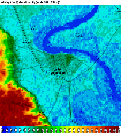
Below is the Elevation map of Al Mayādīn, which displays elevation range with different colors. Scale of the first map is from 182 to 234 m (597 to 768 ft) with average elevation of 194.2 meters (=637 ft) [note 1]
These maps also provides idea of topography and contour of this city, they are displayed at different zoom levels. More info about maps, scale and edge coordinates you can find below images.
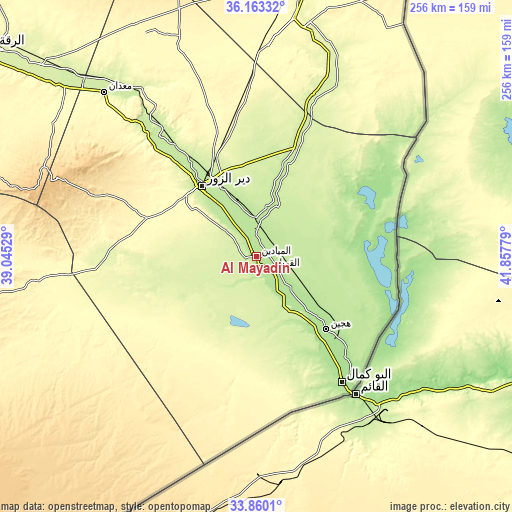
| \ | Map #1 | Map #2 | Topo.Map |
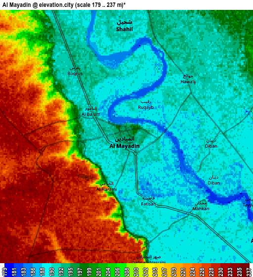
| Scale [m] | 182..234 m | 179..237 m | × |
| Scale [ft] | 597..768 ft | 587..778 ft | × |
| Average | 194.2 m = 637 ft | 202.2 m = 663 ft | × |
| Width | 8 km = 5 mi | 16.01 km = 9.9 mi | 256.1 km = 159.1 mi |
| Height | 8 km = 5 mi | 16.01 km = 9.9 mi | 256.1 km = 159.1 mi |
| ↑Max Latitude | 35.055801° | 35.091767° | 36.16332° |
| Latitude at center | 35.01982° | 35.01982° | 35.01982° |
| ↓Min Latitude | 34.983823° | 34.94781° | 33.8601° |
| ← Min Longitude | 40.407595° | 40.363649° | 39.04529° |
| Longitude center | 40.45154° | 40.45154° | 40.45154° |
| →Max Longitude | 40.495485° | 40.539431° | 41.85779° |
Nearby cities:
Cities around Al Mayādīn sort by population:
• Deir ez-Zor elevation 210 m
45.1 km,  321°
321°
• Ālbū Kamāl 178 m
76.2 km,  145°
145°
• Hajīn 182 m
50 km,  136°
136°
• Subaykhān 188 m
22.9 km, 143°
• Al Kasrah 246 m
77.7 km, 321°
• As Sūsah 173 m
71.2 km, 139°
• Al Jalā’ 178 m
55.7 km, 140°
• Khushām 204 m
34.6 km,  334°
334°
• Mūḩ Ḩasan 200 m
26.7 km, 332°
• Al Buşayrah 207 m
15.3 km,  351°
351°
• Al ‘Ashārah 190 m
14.8 km, 137°
• Dhībān 191 m
5.4 km,  95°
95°
Multilingual:
 En español:
Al Mayādīn elevación 196 m.
 En France:
Al Mayādīn élévation 196 m.
 Auf Deutsch:
Al Mayādīn höhe über dem Meeresspiegel ist 196 m.

Sources and notes:
- [note 1] Map square and city borders are not equal. Map elevation data is calculated only from area inside that square.
- [src 1] Elevation data from geonames database provided with same terms of usage.
- [src 2] The elevation map of Al Mayādīn is generated using elevation data from NASA's 3 arcsec (90m) resolution SRTM data.
- [src 3] Base (background) map © OpenStreetMap contributors tiles are generated by Geofabrik and OpenTopoMap.
Copyright & License:
This Al Mayādīn Elevation Map is licensed under CC BY-SA. You may reuse any part from this page, if you give a proper credit by linking to this URL:
 More info on terms of use page.