Tadmur elevation
Tadmur (Homs), Syria elevation is 418 meters and Tadmur elevation in feet is 1371 ft above sea level [src 1]. Tadmur is a seat of a second-order administrative division (feature code) with elevation that is 111 meters (364 ft) smaller than average city elevation in Syria.
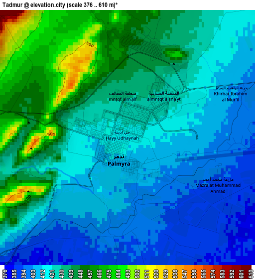
Below is the Elevation map of Tadmur, which displays elevation range with different colors. Scale of the first map is from 376 to 610 m (1234 to 2001 ft) with average elevation of 426 meters (=1398 ft) [note 1]
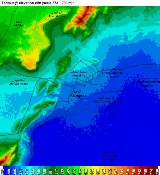
These maps also provides idea of topography and contour of this city, they are displayed at different zoom levels. More info about maps, scale and edge coordinates you can find below images.
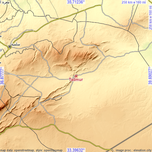
| \ | Map #1 | Map #2 | Topo.Map |
| Scale [m] | 376..610 m | 373..790 m | × |
| Scale [ft] | 1234..2001 ft | 1224..2592 ft | × |
| Average | 426 m = 1398 ft | 446.6 m = 1465 ft | × |
| Width | 8.05 km = 5 mi | 16.1 km = 10 mi | 257.5 km = 160 mi |
| Height | 8.05 km = 5 mi | 16.1 km = 10 mi | 257.5 km = 160 mi |
| ↑Max Latitude | 34.598581° | 34.634747° | 35.71236° |
| Latitude at center | 34.5624° | 34.5624° | 34.5624° |
| ↓Min Latitude | 34.526203° | 34.48999° | 33.39632° |
| ← Min Longitude | 38.240075° | 38.196129° | 36.87777° |
| Longitude center | 38.28402° | 38.28402° | 38.28402° |
| →Max Longitude | 38.327965° | 38.371911° | 39.69027° |
Nearby cities:
Cities around Tadmur sort by population:
• Al Qaryatayn elevation 745 m
102.6 km,  248°
248°
• Mukharram al Fawqānī 609 m
113 km,  284°
284°
• Şabbūrah 503 m
118.2 km,  303°
303°
• Mahīn 924 m
118 km, 252°
• Nāḩiyat as Sab‘ Biyār 749 m
117.3 km,  192°
192°
• As Si‘in 453 m
113.9 km,  313°
313°
• Al Furqlus 667 m
109.6 km,  272°
272°
• Barrī ash Sharqī 551 m
109.3 km, 295°
• As Sab‘ Biyār 823 m
103.1 km,  212°
212°
• Jubb al Jarrāḩ 805 m
92.8 km,  289°
289°
• ‘Uqayribāt 683 m
92 km, 305°
• As Sukhnah 477 m
64.6 km,  56°
56°
Multilingual:
 En español:
Palmira elevación 418 m.
 En France:
Palmyre élévation 418 m.


Sources and notes:
- [note 1] Map square and city borders are not equal. Map elevation data is calculated only from area inside that square.
- [src 1] Elevation data from geonames database provided with same terms of usage.
- [src 2] The elevation map of Tadmur is generated using elevation data from NASA's 3 arcsec (90m) resolution SRTM data.
- [src 3] Base (background) map © OpenStreetMap contributors tiles are generated by Geofabrik and OpenTopoMap.
Copyright & License:
This Tadmur Elevation Map is licensed under CC BY-SA. You may reuse any part from this page, if you give a proper credit by linking to this URL:
 More info on terms of use page.