Mukharram al Fawqānī elevation
Mukharram al Fawqānī (Homs), Syria elevation is 609 meters and Mukharram al Fawqānī elevation in feet is 1998 ft above sea level [src 1]. Mukharram al Fawqānī is a seat of a second-order administrative division (feature code) with elevation that is 80 meters (262 ft) bigger than average city elevation in Syria.
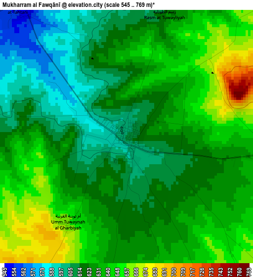
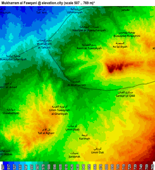
Below is the Elevation map of Mukharram al Fawqānī, which displays elevation range with different colors. Scale of the first map is from 545 to 769 m (1788 to 2523 ft) with average elevation of 627.5 meters (=2059 ft) [note 1]
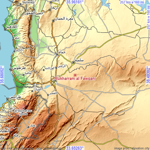
These maps also provides idea of topography and contour of this city, they are displayed at different zoom levels. More info about maps, scale and edge coordinates you can find below images.
| \ | Map #1 | Map #2 | Topo.Map |
| Scale [m] | 545..769 m | 507..769 m | × |
| Scale [ft] | 1788..2523 ft | 1663..2523 ft | × |
| Average | 627.5 m = 2059 ft | 628.1 m = 2061 ft | × |
| Width | 8.02 km = 5 mi | 16.05 km = 10 mi | 256.7 km = 159.5 mi |
| Height | 8.02 km = 5 mi | 16.05 km = 10 mi | 256.7 km = 159.5 mi |
| ↑Max Latitude | 34.851281° | 34.887336° | 35.96161° |
| Latitude at center | 34.81521° | 34.81521° | 34.81521° |
| ↓Min Latitude | 34.779123° | 34.74302° | 33.65263° |
| ← Min Longitude | 37.042825° | 36.998879° | 35.68052° |
| Longitude center | 37.08677° | 37.08677° | 37.08677° |
| →Max Longitude | 37.130715° | 37.174661° | 38.49302° |
Nearby cities:
Cities around Mukharram al Fawqānī sort by population:
• Homs elevation 513 m
34.6 km,  253°
253°
• As Salamīyah 461 m
22 km,  352°
352°
• Ar Rastan 411 m
34.6 km,  290°
290°
• Tallbīsah 460 m
32.6 km,  274°
274°
• Al Ghanţū 455 m
35.7 km, 271°
• ‘Uqayribāt 683 m
42.7 km,  53°
53°
• Şabbūrah 503 m
39.5 km,  16°
16°
• Ar Riqāmā 784 m
34.3 km,  206°
206°
• Al Furqlus 667 m
23.2 km,  179°
179°
• Jubb al Jarrāḩ 805 m
21.8 km,  84°
84°
• Barrī ash Sharqī 551 m
21.2 km,  29°
29°
• ‘Ayn an Nasr 476 m
14.7 km,  281°
281°
Multilingual:
 En español:
Mukharram al Fawqānī elevación 609 m.
 En France:
Mukharram al Fawqānī élévation 609 m.
 Auf Deutsch:
Mukharram al Fawqānī höhe über dem Meeresspiegel ist 609 m.
 На русском:
Mukharram al Fawqānī высота над уровнем моря 609 м
Sources and notes:
- [note 1] Map square and city borders are not equal. Map elevation data is calculated only from area inside that square.
- [src 1] Elevation data from geonames database provided with same terms of usage.
- [src 2] The elevation map of Mukharram al Fawqānī is generated using elevation data from NASA's 3 arcsec (90m) resolution SRTM data.
- [src 3] Base (background) map © OpenStreetMap contributors tiles are generated by Geofabrik and OpenTopoMap.
Copyright & License:
This Mukharram al Fawqānī Elevation Map is licensed under CC BY-SA. You may reuse any part from this page, if you give a proper credit by linking to this URL:
 More info on terms of use page.