Nāḩiyat as Sab‘ Biyār elevation
Nāḩiyat as Sab‘ Biyār (Rif-dimashq), Syria elevation is 749 meters and Nāḩiyat as Sab‘ Biyār elevation in feet is 2457 ft above sea level [src 1]. Nāḩiyat as Sab‘ Biyār is a seat of a third-order administrative division (feature code) with elevation that is 220 meters (722 ft) bigger than average city elevation in Syria.
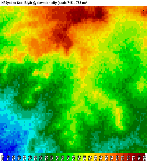
Below is the Elevation map of Nāḩiyat as Sab‘ Biyār, which displays elevation range with different colors. Scale of the first map is from 715 to 783 m (2346 to 2569 ft) with average elevation of 747.9 meters (=2454 ft) [note 1]
These maps also provides idea of topography and contour of this city, they are displayed at different zoom levels. More info about maps, scale and edge coordinates you can find below images.
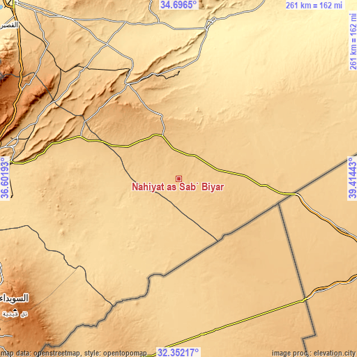
| \ | Map #1 | Topo.Map |
| Scale [m] | 715..783 m | × |
| Scale [ft] | 2346..2569 ft | × |
| Average | 747.9 m = 2454 ft | × |
| Width | 8.15 km = 5.1 mi | 260.7 km = 162 mi |
| Height | 8.15 km = 5.1 mi | 260.7 km = 162 mi |
| ↑Max Latitude | 33.568904° | 34.6965° |
| Latitude at center | 33.53228° | 33.53228° |
| ↓Min Latitude | 33.495641° | 32.35217° |
| ← Min Longitude | 37.964235° | 36.60193° |
| Longitude center | 38.00818° | 38.00818° |
| →Max Longitude | 38.052125° | 39.41443° |
Nearby cities:
Cities around Nāḩiyat as Sab‘ Biyār sort by population:
• Tadmur elevation 418 m
117.3 km,  12°
12°
• An Nabk 1272 m
130.3 km,  294°
294°
• Yabrūd 1382 m
134 km, 291°
• Jayrūd 815 m
121.4 km,  284°
284°
• Al Qaryatayn 745 m
105 km,  317°
317°
• Al Quţayfah 934 m
132.3 km, 279°
• Şadad 919 m
132.3 km,  310°
310°
• Dayr ‘Aţīyah 1229 m
130.6 km,  298°
298°
• Ar Ruḩaybah 833 m
123 km, 281°
• Aḑ Ḑumayr 694 m
122.4 km, 275°
• Mahīn 924 m
117.9 km, 311°
• As Sab‘ Biyār 823 m
40.7 km, 312°
Multilingual:
 En español:
Nāḩiyat as Sab‘ Biyār elevación 749 m.
 En France:
Nāḩiyat as Sab‘ Biyār élévation 749 m.
 Auf Deutsch:
Nāḩiyat as Sab‘ Biyār höhe über dem Meeresspiegel ist 749 m.
 На русском:
Nāḩiyat as Sab‘ Biyār высота над уровнем моря 749 м
Sources and notes:
- [note 1] Map square and city borders are not equal. Map elevation data is calculated only from area inside that square.
- [src 1] Elevation data from geonames database provided with same terms of usage.
- [src 2] The elevation map of Nāḩiyat as Sab‘ Biyār is generated using elevation data from NASA's 3 arcsec (90m) resolution SRTM data.
- [src 3] Base (background) map © OpenStreetMap contributors tiles are generated by Geofabrik and OpenTopoMap.
Copyright & License:
This Nāḩiyat as Sab‘ Biyār Elevation Map is licensed under CC BY-SA. You may reuse any part from this page, if you give a proper credit by linking to this URL:
 More info on terms of use page.