Mahīn elevation
Mahīn (Homs), Syria elevation is 924 meters and Mahīn elevation in feet is 3031 ft above sea level [src 1]. Mahīn is a seat of a third-order administrative division (feature code) with elevation that is 395 meters (1296 ft) bigger than average city elevation in Syria.
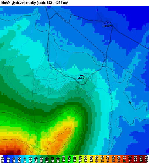
Below is the Elevation map of Mahīn, which displays elevation range with different colors. Scale of the first map is from 852 to 1234 m (2795 to 4049 ft) with average elevation of 932.7 meters (=3060 ft) [note 1]
These maps also provides idea of topography and contour of this city, they are displayed at different zoom levels. More info about maps, scale and edge coordinates you can find below images.
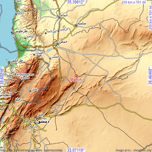
| \ | Map #1 | Topo.Map |
| Scale [m] | 852..1234 m | × |
| Scale [ft] | 2795..4049 ft | × |
| Average | 932.7 m = 3060 ft | × |
| Width | 8.08 km = 5 mi | 258.5 km = 160.6 mi |
| Height | 8.08 km = 5 mi | 258.5 km = 160.6 mi |
| ↑Max Latitude | 34.278° | 35.39612° |
| Latitude at center | 34.24168° | 34.24168° |
| ↓Min Latitude | 34.205344° | 33.07119° |
| ← Min Longitude | 37.014485° | 35.65218° |
| Longitude center | 37.05843° | 37.05843° |
| →Max Longitude | 37.102375° | 38.46468° |
Nearby cities:
Cities around Mahīn sort by population:
• Homs elevation 513 m
62.1 km,  330°
330°
• An Nabk 1272 m
38.8 km,  231°
231°
• Al Quşayr 541 m
52.9 km,  303°
303°
• Yabrūd 1382 m
47.8 km, 230°
• Jayrūd 815 m
56.6 km,  211°
211°
• Al Qaryatayn 745 m
16.8 km,  94°
94°
• Qārah 1287 m
30.6 km,  251°
251°
• Al Furqlus 667 m
40.6 km,  3°
3°
• Ar Riqāmā 784 m
35.4 km,  338°
338°
• Hisya 780 m
33.4 km, 304°
• Dayr ‘Aţīyah 1229 m
31.3 km,  238°
238°
• Şadad 919 m
14.5 km, 302°
Multilingual:
 En español:
Mahīn elevación 924 m.
 En France:
Mahīn élévation 924 m.


Sources and notes:
- [note 1] Map square and city borders are not equal. Map elevation data is calculated only from area inside that square.
- [src 1] Elevation data from geonames database provided with same terms of usage.
- [src 2] The elevation map of Mahīn is generated using elevation data from NASA's 3 arcsec (90m) resolution SRTM data.
- [src 3] Base (background) map © OpenStreetMap contributors tiles are generated by Geofabrik and OpenTopoMap.
Copyright & License:
This Mahīn Elevation Map is licensed under CC BY-SA. You may reuse any part from this page, if you give a proper credit by linking to this URL:
 More info on terms of use page.