Qārah elevation
Qārah (Rif-dimashq), Syria elevation is 1287 meters and Qārah elevation in feet is 4222 ft above sea level [src 1]. Qārah is a populated place (feature code) with elevation that is 758 meters (2487 ft) bigger than average city elevation in Syria.
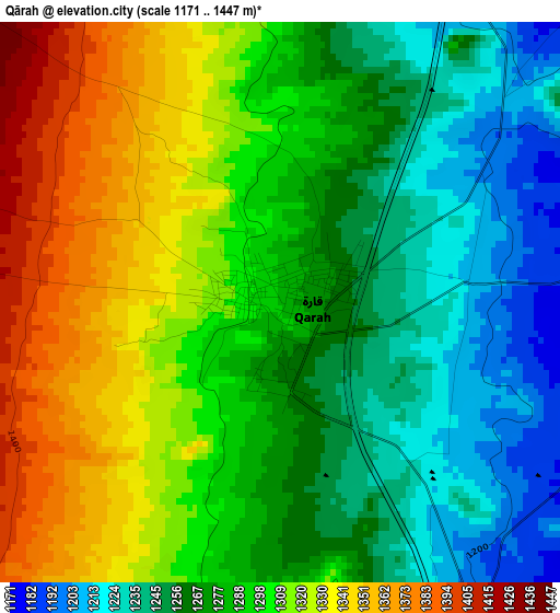
Below is the Elevation map of Qārah, which displays elevation range with different colors. Scale of the first map is from 1171 to 1447 m (3842 to 4747 ft) with average elevation of 1288.2 meters (=4226 ft) [note 1]
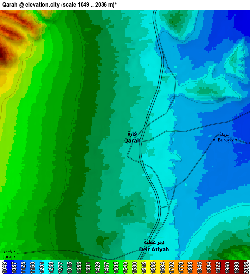
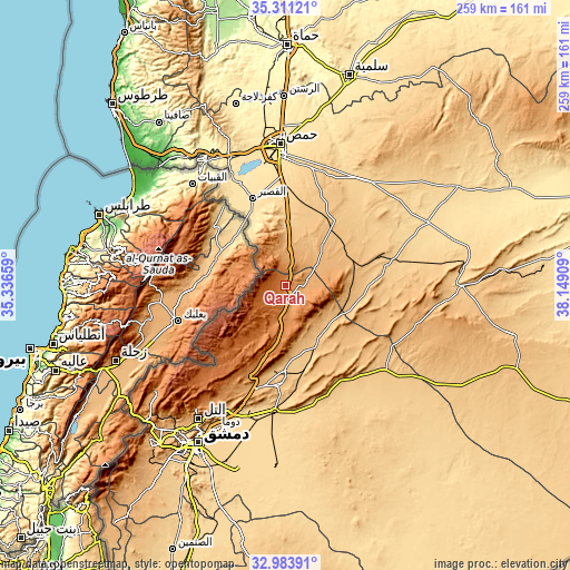
These maps also provides idea of topography and contour of this city, they are displayed at different zoom levels. More info about maps, scale and edge coordinates you can find below images.
| \ | Map #1 | Map #2 | Topo.Map |
| Scale [m] | 1171..1447 m | 1049..2036 m | × |
| Scale [ft] | 3842..4747 ft | 3442..6680 ft | × |
| Average | 1288.2 m = 4226 ft | 1320.1 m = 4331 ft | × |
| Width | 8.09 km = 5 mi | 16.17 km = 10 mi | 258.8 km = 160.8 mi |
| Height | 8.09 km = 5 mi | 16.17 km = 10 mi | 258.8 km = 160.8 mi |
| ↑Max Latitude | 34.191938° | 34.22828° | 35.31121° |
| Latitude at center | 34.15558° | 34.15558° | 34.15558° |
| ↓Min Latitude | 34.119207° | 34.082818° | 32.98391° |
| ← Min Longitude | 36.698895° | 36.654949° | 35.33659° |
| Longitude center | 36.74284° | 36.74284° | 36.74284° |
| →Max Longitude | 36.786785° | 36.830731° | 38.14909° |
Nearby cities:
Cities around Qārah sort by population:
• An Nabk elevation 1272 m
14.7 km,  185°
185°
• Al Quşayr 541 m
41.9 km,  339°
339°
• Yabrūd 1382 m
22.2 km,  200°
200°
• Jayrūd 815 m
38.8 km,  180°
180°
• Ma‘lūlā 1426 m
39 km,  207°
207°
• Ar Ruḩaybah 833 m
45.9 km, 184°
• Ar Riqāmā 784 m
45.6 km,  20°
20°
• ‘Assāl al Ward 1640 m
44.3 km,  223°
223°
• Mahīn 924 m
30.6 km,  71°
71°
• Hisya 780 m
28.5 km,  2°
2°
• Şadad 919 m
24.2 km,  43°
43°
• Dayr ‘Aţīyah 1229 m
7.1 km,  160°
160°
Multilingual:
 En español:
Qārah elevación 1287 m.
 En France:
Qārah élévation 1287 m.


Sources and notes:
- [note 1] Map square and city borders are not equal. Map elevation data is calculated only from area inside that square.
- [src 1] Elevation data from geonames database provided with same terms of usage.
- [src 2] The elevation map of Qārah is generated using elevation data from NASA's 3 arcsec (90m) resolution SRTM data.
- [src 3] Base (background) map © OpenStreetMap contributors tiles are generated by Geofabrik and OpenTopoMap.
Copyright & License:
This Qārah Elevation Map is licensed under CC BY-SA. You may reuse any part from this page, if you give a proper credit by linking to this URL:
 More info on terms of use page.