Ma‘lūlā elevation
Ma‘lūlā (Rif-dimashq), Syria elevation is 1426 meters and Ma‘lūlā elevation in feet is 4678 ft above sea level [src 1]. Ma‘lūlā is a seat of a third-order administrative division (feature code) with elevation that is 897 meters (2943 ft) bigger than average city elevation in Syria.
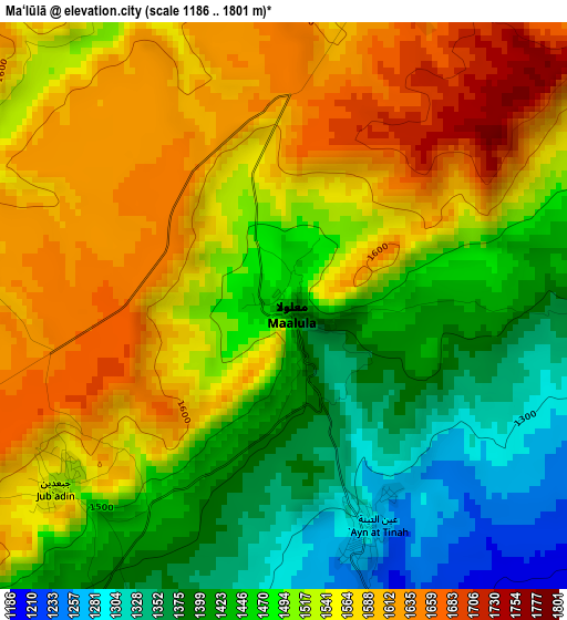
Below is the Elevation map of Ma‘lūlā, which displays elevation range with different colors. Scale of the first map is from 1186 to 1801 m (3891 to 5909 ft) with average elevation of 1507.9 meters (=4947 ft) [note 1]
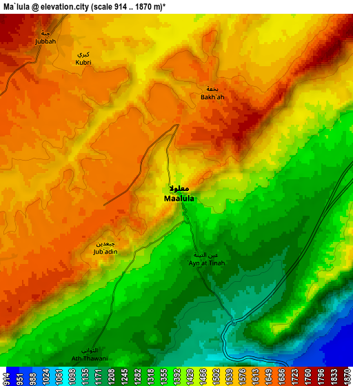
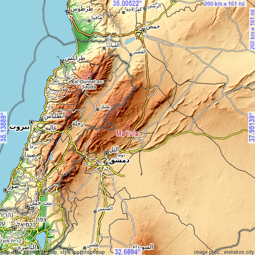
These maps also provides idea of topography and contour of this city, they are displayed at different zoom levels. More info about maps, scale and edge coordinates you can find below images.
| \ | Map #1 | Map #2 | Topo.Map |
| Scale [m] | 1186..1801 m | 914..1870 m | × |
| Scale [ft] | 3891..5909 ft | 2999..6135 ft | × |
| Average | 1507.9 m = 4947 ft | 1462.6 m = 4799 ft | × |
| Width | 8.12 km = 5 mi | 16.23 km = 10.1 mi | 259.7 km = 161.4 mi |
| Height | 8.12 km = 5 mi | 16.23 km = 10.1 mi | 259.7 km = 161.4 mi |
| ↑Max Latitude | 33.881781° | 33.918256° | 35.00522° |
| Latitude at center | 33.84529° | 33.84529° | 33.84529° |
| ↓Min Latitude | 33.808784° | 33.772262° | 32.6694° |
| ← Min Longitude | 36.501195° | 36.457249° | 35.13889° |
| Longitude center | 36.54514° | 36.54514° | 36.54514° |
| →Max Longitude | 36.589085° | 36.633031° | 37.95139° |
Nearby cities:
Cities around Ma‘lūlā sort by population:
• Douma elevation 660 m
33.1 km,  203°
203°
• At Tall 1003 m
33.9 km,  219°
219°
• An Nabk 1272 m
26.1 km,  40°
40°
• Yabrūd 1382 m
17.2 km, 36°
• Jayrūd 815 m
18.4 km,  103°
103°
• Al Quţayfah 934 m
12.9 km,  156°
156°
• Dayr ‘Aţīyah 1229 m
34.6 km, 36°
• Aḑ Ḑumayr 694 m
26.3 km,  148°
148°
• Şaydnāyā 1365 m
23.2 km, 223°
• Ar Ruḩaybah 833 m
18.5 km,  127°
127°
• Rankūs 1570 m
17.6 km,  235°
235°
• ‘Assāl al Ward 1640 m
12.3 km,  280°
280°
Multilingual:
 En español:
Ma‘lūlā elevación 1426 m.
 En France:
Ma‘lūlā élévation 1426 m.
 Auf Deutsch:
Ma‘lūlā höhe über dem Meeresspiegel ist 1426 m.

Sources and notes:
- [note 1] Map square and city borders are not equal. Map elevation data is calculated only from area inside that square.
- [src 1] Elevation data from geonames database provided with same terms of usage.
- [src 2] The elevation map of Ma‘lūlā is generated using elevation data from NASA's 3 arcsec (90m) resolution SRTM data.
- [src 3] Base (background) map © OpenStreetMap contributors tiles are generated by Geofabrik and OpenTopoMap.
Copyright & License:
This Ma‘lūlā Elevation Map is licensed under CC BY-SA. You may reuse any part from this page, if you give a proper credit by linking to this URL:
 More info on terms of use page.