Rankūs elevation
Rankūs (Rif-dimashq), Syria elevation is 1570 meters and Rankūs elevation in feet is 5151 ft above sea level [src 1]. Rankūs is a seat of a third-order administrative division (feature code) with elevation that is 1041 meters (3415 ft) bigger than average city elevation in Syria.
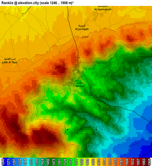
Below is the Elevation map of Rankūs, which displays elevation range with different colors. Scale of the first map is from 1246 to 1908 m (4088 to 6260 ft) with average elevation of 1611 meters (=5285 ft) [note 1]
These maps also provides idea of topography and contour of this city, they are displayed at different zoom levels. More info about maps, scale and edge coordinates you can find below images.
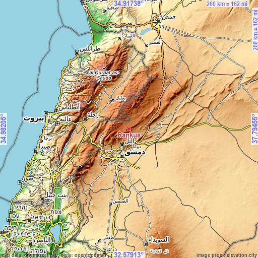
| \ | Map #1 | Topo.Map |
| Scale [m] | 1246..1908 m | × |
| Scale [ft] | 4088..6260 ft | × |
| Average | 1611 m = 5285 ft | × |
| Width | 8.12 km = 5 mi | 260 km = 161.6 mi |
| Height | 8.12 km = 5 mi | 260 km = 161.6 mi |
| ↑Max Latitude | 33.792759° | 34.91738° |
| Latitude at center | 33.75623° | 33.75623° |
| ↓Min Latitude | 33.719686° | 32.57913° |
| ← Min Longitude | 36.344355° | 34.98205° |
| Longitude center | 36.3883° | 36.3883° |
| →Max Longitude | 36.432245° | 37.79455° |
Nearby cities:
Cities around Rankūs sort by population:
• Douma elevation 660 m
20.6 km,  176°
176°
• At Tall 1003 m
17.7 km,  203°
203°
• ‘Irbīn 688 m
24.4 km, 184°
• Ḩarastā 710 m
22.1 km,  185°
185°
• Az Zabadānī 1183 m
26.8 km,  262°
262°
• Al Quţayfah 934 m
19.7 km,  95°
95°
• Ma‘lūlā 1426 m
17.6 km,  55°
55°
• Kafr Baţnā 660 m
27.2 km, 183°
• ‘Ayn al Fījah 822 m
24.6 km,  230°
230°
• Sirghāyā 1367 m
22.1 km,  285°
285°
• ‘Assāl al Ward 1640 m
12.3 km,  11°
11°
• Şaydnāyā 1365 m
7 km, 192°
Multilingual:
 En español:
Rankūs elevación 1570 m.
 En France:
Rankūs élévation 1570 m.


Sources and notes:
- [note 1] Map square and city borders are not equal. Map elevation data is calculated only from area inside that square.
- [src 1] Elevation data from geonames database provided with same terms of usage.
- [src 2] The elevation map of Rankūs is generated using elevation data from NASA's 3 arcsec (90m) resolution SRTM data.
- [src 3] Base (background) map © OpenStreetMap contributors tiles are generated by Geofabrik and OpenTopoMap.
Copyright & License:
This Rankūs Elevation Map is licensed under CC BY-SA. You may reuse any part from this page, if you give a proper credit by linking to this URL:
 More info on terms of use page.