At Tall elevation
At Tall (Rif-dimashq), Syria elevation is 1003 meters and At Tall elevation in feet is 3291 ft above sea level [src 1]. At Tall is a seat of a second-order administrative division (feature code) with elevation that is 474 meters (1555 ft) bigger than average city elevation in Syria.
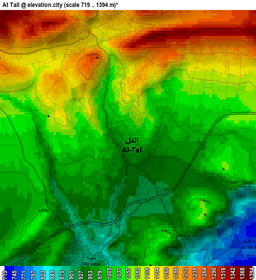
Below is the Elevation map of At Tall, which displays elevation range with different colors. Scale of the first map is from 719 to 1394 m (2359 to 4573 ft) with average elevation of 1040.7 meters (=3414 ft) [note 1]
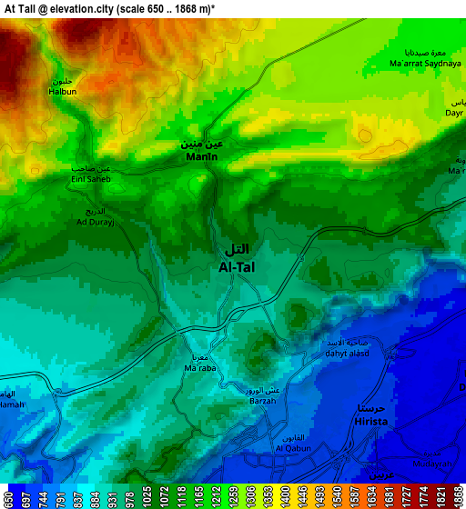
These maps also provides idea of topography and contour of this city, they are displayed at different zoom levels. More info about maps, scale and edge coordinates you can find below images.
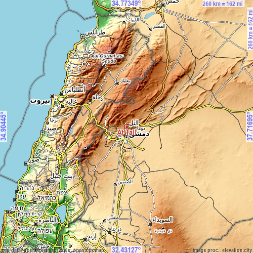
| \ | Map #1 | Map #2 | Topo.Map |
| Scale [m] | 719..1394 m | 650..1868 m | × |
| Scale [ft] | 2359..4573 ft | 2133..6129 ft | × |
| Average | 1040.7 m = 3414 ft | 1056.8 m = 3467 ft | × |
| Width | 8.14 km = 5.1 mi | 16.28 km = 10.1 mi | 260.4 km = 161.8 mi |
| Height | 8.14 km = 5.1 mi | 16.28 km = 10.1 mi | 260.4 km = 161.8 mi |
| ↑Max Latitude | 33.646921° | 33.683496° | 34.77349° |
| Latitude at center | 33.61033° | 33.61033° | 33.61033° |
| ↓Min Latitude | 33.573724° | 33.537102° | 32.43127° |
| ← Min Longitude | 36.266755° | 36.222809° | 34.90445° |
| Longitude center | 36.3107° | 36.3107° | 36.3107° |
| →Max Longitude | 36.354645° | 36.398591° | 37.71695° |
Nearby cities:
Cities around At Tall sort by population:
• Damascus elevation 701 m
11.3 km,  189°
189°
• Douma 660 m
9.5 km,  116°
116°
• ‘Irbīn 688 m
9.6 km,  147°
147°
• Ḩarastā 710 m
7.6 km,  138°
138°
• Al Ḩajar al Aswad 676 m
17 km,  182°
182°
• Babīlā 669 m
15.6 km,  173°
173°
• Al Mulayḩah 661 m
15.2 km,  156°
156°
• Jaramānā 670 m
14.2 km, 166°
• Kafr Baţnā 660 m
12.4 km, 152°
• ‘Ayn al Fījah 822 m
11.9 km,  272°
272°
• Qadsayyā 791 m
11.2 km,  231°
231°
• Şaydnāyā 1365 m
10.9 km,  30°
30°
Multilingual:
 En español:
At Tall elevación 1003 m.
 En France:
At Tall élévation 1003 m.
 Auf Deutsch:
At Tall höhe über dem Meeresspiegel ist 1003 m.

Sources and notes:
- [note 1] Map square and city borders are not equal. Map elevation data is calculated only from area inside that square.
- [src 1] Elevation data from geonames database provided with same terms of usage.
- [src 2] The elevation map of At Tall is generated using elevation data from NASA's 3 arcsec (90m) resolution SRTM data.
- [src 3] Base (background) map © OpenStreetMap contributors tiles are generated by Geofabrik and OpenTopoMap.
Copyright & License:
This At Tall Elevation Map is licensed under CC BY-SA. You may reuse any part from this page, if you give a proper credit by linking to this URL:
 More info on terms of use page.